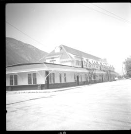
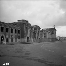
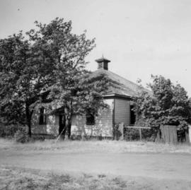
Photograph depicts Mount Pleasant Elementary School in Vancouver. Date over doorway was 1892.
Photo depict Movat's store where you could buy food, dry goods, and hardware among other things. Located beside the original pier on Salt Spring Island, now little used for general and commercial traffic.
Photograph depicts the Mussenden Building used by the Hudson's Bay Company. It is located on Water St. in Vancouver, B.C. View is from the north side looking east.
Photograph depicts Myra depot on the CPR Kettle Valley line. The depot is at mile 83.8 and is only 8 miles from Kelowna but 2800 ft. above it. Trevor Davies, aged 8 3/4, is in the foreground.
Photograph depicts the Nelson CPR depot . All the freight traffic work is handled at this office for a wide area. The view is looking west.
Photograph depicts the Nelson CPR depot, built in 1899. Since there are no passenger trains, freights used the front line, adjacent to the depot. The photograph was taken from the platform and shows a view looking east.
Photograph depicts the Nelson CPR depot, built in 1899 and still well-maintained. Streetcars had a terminal in this yard from 1899-1949, for what was probable the shortest street car system in Canada. The view is looking north and shows the rear view.
Photograph depicts a new bridge on the CNR Okanagan Branch. The old steel bridge on the right had been dismantled.
Photograph depicts a new CN overpass in Campbell Creek. The new part of the Trans-Canada Highway beneath it had yet to be paved.
Photograph depicts a new CN overpass in Campbell Creek. The grade crossing at the newly created service/business road was built on the south side of a road/rail complex.
Photograph depicts a new CN overpass in Campbell Creek. Looking at new eastbound lane of the Trans Canada Highway. It was all paid for by the Provincial Department of Highways in order to convert the 2 lanes into 4 in order to improve visibility and stretch the highway.
Photograph depicts a new concrete bridge being constructed. The old one is one the right.
Photograph depicts the newsprint plant of MacMillan, Bloedell, and Powell River Ltd. In Powell River, B.C. The view is looking northwards and shows that the plant is working on Easter Day/
Photograph depicts the office of the Central Coal Co. Ltd., located on the south outskirts of Nanaimo, B.C. beside the Esquimalt and Nanaimo Railway. The building is one of the last pieces of evidence of coal distribution in Nanaimo.
Photograph taken at Okangan Lake, on Alexis Beach. O'Keefe Ranch is located at the head of the lake. Visible is an old house that was used as a hay barn.
Photograph depicts an old building at 119 Water St. in Vancouver, B.C.
Photograph depicts an old church or school being demolished at 1701-1721 West 3rd Ave. (and Pine), in Vancouver, B.C.
Photograph depicts the end of the old Coal Harbour extension of the C.P.R. line from Vancouver. It was disused for several years. The view is looking east with Woodward's Marina behind.
Photograph depicts one of various old lead and zinc mine buildings. Behind this building, on the foreshore, were a few men working on the reclamation of tailings and waste from the mine that was dumped in Kootenay Lake.
Photograph depicts one of the few surviving old style garages in west end Vancouver on Barclay St.
Photograph depicts an original trappers cabin on Staubert Lake.
Photograph depicts an outhouse on Notch Hill in the Shuswap. Helper locomotives were stationed here to lift heavy trains over Notch Hill. It was presumably used by waiting engine crews.
Photograph depicts the Pacific Press Ltd. Vancouver Sun building at Beatty and West Pender St. The view is looking northeast from Beatty St. It was vacated by the Vancouver Sun at Christmas 1965 with the neon "Sun" sign on the tower removed.
Photograph depicts a painting on the fence outside a courthouse on Howe and Granville St. In Vancouver, B.C. Each artist was granted a permit and panel by City Council.
Photograph depicts a painting on a fence outside a courthouse on Howe St. in Vancouver, B.C. The painting shows the natural grandeur of B.C. partially blocked out by a super motel with a bewildered moose forced to become an ornamental fountain. The whole forecourt is being bulldozed to make way for the Centennial fountain.
Photograph depicts a partially demolished Great Northern Railway depot and Canadian National Railway (CN) depot behind it, in Vancouver.
Photograph depicts the Nanaimo passenger depot of the Esquimalt and Nanaimo Railway (at right) and the E & N freight shed (at left).
Photograph depicts peat barns on the New Westminster Highway on Lulu Island, near the #8 Rd., half a mile west of rail crossing.
Photograph depicts the Penticton CPR depot. The view is looking northwest.
Photograph depicts Pier B of C.P.R., just west of the C.P.R. railway station. This is the only pier accessible to ocean going passenger liners and is used by P&O vessels. Facilities generally in adequate for the 1960s.
Photograph depicts Pioneer Sash and Door Company Ltd. Davies suggests that it may have been the same as S.C. Smith Ltd., which commenced operating in Vernon in 1883. In the early days, products were verandah posters, balusters, and fancy trim. Most products were sent to the U.S. Most of the fancy trim in early north Okanagan homes came from this plant. In 1972, its main output was cedar panelling for Florida.
Photograph depicts the CPR Pitt River swing bridge in an open position.
Photograph depicts a post office on Main St. in Cumberland on Vancouver Island. It was built in 1907 in a similar style to the building in Ladysmith.
Photograph depicts the post office, store, and gas pump in Clayburn, north of Abbotsford, B.C.
Photograph depicts the Provincial Government Mine Rescue Station established in 1913 in Nanaimo, B.C. It is in the south side of the city.
Photograph depicts a Public Weigh Scale that was operated in Vancouver, on Main Street, opposite the CN Depot.
Photograph depicts a pump house on the Island Highway, north of Qualicum Beach, Vancouver Island.
Photograph depicts railway track previously owned by BCER. It led onto the east end of Lulu Island and then to Annacis Island. Looking from the Naew West River Walk to the Queensborough bridge that was protected by signals and had a high chain link fence to deter pedestrians. It was likely that the rail was only used at night. Originally built by Canadian Northern Railway to reach Steveston, circa 1917.
Photograph depicts a railcar and possible shed or depot. Location and details unknown.
Photograph depicts an RCAF Langer that was erected in 1942 as part of a flying boat base to counter possible Japanese sea and activities. It was used subsequently as whaling station premises.
Photograph depicts a replacement rail bridge. Forms sat on a temporary pile of dirt, which in turns sat on a road bed of a new highway that had just been cut.
Photograph depicts a Roman Catholic church, "Our Lady of Lourdes," on the First Nations reservation, Sechelt Village. It was built in 1907 and is now closed, but the heavy bell is still in position in the belfry.
Photograph depicts a bell tower of a Roman Catholic church in the Saanich Peninsula.
Photograph depicts Royal Oak Apartments on Kingsway in Burnaby.
Photograph depicts a Ruston steam roller owned by Gary Wellburn in Duncan, BC
Photograph depicts a completely rebuilt saloon that was done so based on historical sketches and photos.
Photograph depicts "Salt Spring Island Trading Company Ltd." store.
Photograph depicts a one roomed school that was seemingly still in use.
Photograph depicts a school room or church on the road between Louis Creek and Adams Lake.
Photograph depicts the schoolhouse of Chinatown in Nanaimo, B.C. It is the only surviving building; the others were destroyed by a fire.