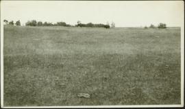
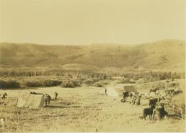
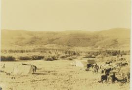
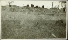
Photograph depicts group of buffaloes on horizon. Trees in midground, field in foreground. It is believed that this photograph was given to Lillian & A.K. Bourchier by their niece Jean. Location unknown; possibly Alberta as the Bourchier family moved to Alberta in 1902.
Photograph depicts two buffalo visible by trees on horizon, field in foreground. It is believed that this photograph was given to Lillian & A.K. Bourchier by their niece Jean.
Image depicts a vehicle parked beside a small, wooden house in Upper Fraser, B.C. Map coordinates 54°07'05.7"N 121°56'38.9"W
Image depicts numerous buildings and a dock on the shore of Haida Gwaii, B.C..
Image depicts several old buildings in a field, one of which has a caved-in roof, in Newlands, B.C. Map coordinates 54°06'28.2"N 122°12'01.0"W
Photograph depicts three buildings and a water tower on top of a deforested hill with water in the foreground.
Photograph depicts a wooden building under construction and piles of wood planks on the shoreline.
Image depicts the Bulkley River.
Image depicts the Bulkley River near Moricetown, B.C.
Image depicts numerous unknown individuals standing by the Bulkley River near Moricetown, B.C.
Image depicts a small group of people standing near the Bulkley River at Moricetown, B.C.
Photograph depicts the Bulkley River and rocky bank with a red-roofed house set behind.
Photograph depicts the aftermath of the flooded Bulkley River near Moricetown.
Image depicts a section of forest in the Bulkley Valley.
Image depicts a view of Bulkley Valley.
Image depicts a stretch of road through the Bulkley Valley.
Image depicts a bulldozer and truck in an unknown location.
Photograph depicts man believed to be Bob Baxter on bulldozer by large framework structure in snow. House stands in background as well as a truck with "CITY OF PRINCE GEORGE" visible on its passenger door. Handwritten annotation on recto of photograph: "Civic centre 1948."
Photograph depicts man driving bulldozer in thick forest, small cleared area in foreground.
Slide depicts a bulldozer clearing ground, likely at the Aleza Lake Experiment Station.
Bulldozer visible to left of road in distance, mountain in background.
Item is a photograph of a bulldozer removing debris from train tracks on August 27, 1956 location unknown.
Image depicts an old, half-collapsed house in Likely, B.C.. The slide labels it as "Bullion house."
Image depicts the upper end of the Bullion Pit in Likely, B.C.
Image depicts Burns Lake, B.C.
Image depicts a stretch of road somewhere at Burns Lake, B.C.
Image depicts a cabin at an uncertain location.
Photograph depicts a log cabin with sod roof in forest clearing. Handwritten annotation on recto of photograph: "Sayer Creek."
Photograph depicts the boom, stick, and bucket of a "Northwest" cable shovel loading a dump truck in excavation area, snow and forest in background.
Image depicts a nature trail along the Nechako River at Island Cache looking west with the cutbanks in the background. Map coordinates 53°55'36.2"N 122°45'11.8"W
Image depicts some cacti somewhere near Soda Creek, B.C.
Slide depicts a camel and two llamas in an enclosed pasture. The photograph was taken in Kaleden, BC. Original slide index description: "Camel & Llamas in pasture, Kaleden."
Slide depicts a close up of a camel behind a fence. The photograph was taken in Kaleden, BC. Original slide index description: "Camel, Kaleden."
Image depicts an unknown individual eating in a camp somewhere in South Tweedsmuir Provincial Park.
Image depicts a campsite somewhere near Berg Lake.
Image depicts group of people at a camp somewhere in Mt. Robson Provincial Park.
Image depicts a camp on the shore of a lake in South Tweedsmuir Provincial Park. The man sitting in the bottom right corner is possibly Kent Sedgwick.
Image depicts a group of individuals at camp somewhere in Mt. Robson Provincial Park.
Image depicts a camp and what is likely Mt. Robson in the background.
Image depicts a camp of people with Mt. Robson and the Berg Glacier in the background.
Photograph depicts three men and dog in tent campsite. Cooking supplies and miscellaneous items in throughout, forest trees in background. Handwritten annotation on verso and recto of this photograph reads: "Camp on Upper end of Grand Canyon".
Photograph depicts a camp with three tents within a snowy forested landscape.
Photograph depicts pack horses at rest at a camp site situated on a grassy field. In the background a forested environment is visible.
Photograph depicts pack horses resting at a camp site situated on a grassy field. In the background a forested environment is visible.
Image depicts Kent Sedgwick (the man with a pipe in green) and an unknown individual sitting around a campfire somewhere in South Tweedsmuir Provincial Park.