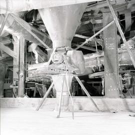
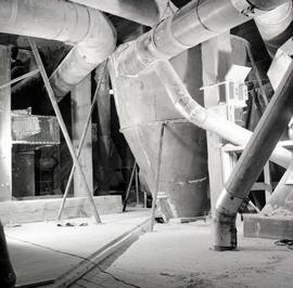
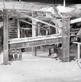
Photograph depicts the inside of a mill.
Photograph depicts the Cassiar mine. North and South peak featured in background, and West peak in left foreground. Pit is being developed between South peak and West peak. Old mine garage is visible in lower centre of image, and crushing plant in right foreground. Mountain range in distance.
Crushing plant and strip mining area visible in Cassiar mountain range.
Photograph depicts chute from distance. Annotation on verso of photograph: "CASSIAR ASBESTOS CORP. LTD. MINE AND ORE CHUTE ON McDAMES MOUNTAIN".
Photograph depicts the pit mine, and road in valley below. Town of Cassiar can be seen in distance at foot of south mountain range.
Photograph depicts the town of Cassiar in distance behind pit mine in foreground. South mountain range in background. Photograph was taken from the air, portion of plane visible in top left of image.
Photograph depicts the pit mine, and road in valley below. Town of Cassiar can be seen in distance at foot of south mountain range.
Photograph depicts buildings near West Peak of Cassiar mine. Haul trucks parked near old mine garage in background, new mine garage and unknown buildings in foreground. Mine valley crosses midground, expansive western mountain range in background.
Switchback road, power lines and tramline towers are believed to be visible in the background valley. Construction of a long structure near the edge of the excavation area can be seen in midground; this is speculated to be the section of the crusher building which housed conveyor "B".
Photograph depicts the primary crushing plant in foreground. Mine road can be seen below, and plant is visible in distance. South mountains in background. Handwritten annotation on recto of photograph: "1961-1962".
Photograph depicts the mine road in valley bellow mine. Cassiar plant and tailings pile in foreground. Handwritten annotation on recto of photograph: "Oct. 25 / 65 4:25 PM."
Photograph depicts the mine road in valley below bulldozer parked on edge of mountain. Cassiar plant and town visible in distance, south mountains behind them in background. Photo also depicts what appears to be a cloud rising from the tailings pile in plantsite.
Photograph depicts view of mine road in valley, from mountain above. Plant, tailings pile, and town visible in distance. South mountains in background. Handwritten annotation on verso of photograph: "1961", on recto: Townsite and Plantsite from mine."
Photograph depicts the mine road in valley, view from mountain above. Plant, tailings pile, and town visible in distance. South mountains in background. Handwritten annotation on recto of photograph: "1961-1962".
Photograph depicts the Cassiar mine, switchback road in foreground, mountain range in background. Pit is visible to right of West peak. The new mine garage can be seen on West peak just above "#7 switchback" in centre of image.
Photograph depicts the Cassiar mine in left area of mountain range. The new mine garage can be seen on West peak on far left.
Photograph depicts the Cassiar mine in mountain range. Crushing plant and tramline station visible in foreground, and new mine garage can be seen on West peak on far left.
Photograph depicts the Cassiar mine above valley bellow, north east mountain range in background. Photograph was taken from the air, portion of plane visible in top left of image.
Photograph depicts the mine valley in foreground below Cassiar Mine, north east mountain range in background.
Photograph depicts the Cassiar mine in foreground, north east mountain range in background. Tramline station and crushing plant visible in foreground in front of pit. Photograph was taken from the air, portion of plane visible in top left of image.
Photograph depicts the Cassiar mine in foreground, north east mountain range in background. Tramline station and crushing plant visible in foreground, west of pit. Photograph was taken from the air, portion of plane visible in top left of image.
Photograph depicts the Cassiar mine above valley, north mountain range in background. Tramline station and crushing plant visible to west of pit. Photograph was taken from the air, portion of plane visible in top left of image.
Photograph depicts the Cassiar mine to right of mine valley, north mountain range in background. Tramline station visible on west of open pit, and the new mine garage can be seen behind the West peak.
Photograph depicts the Cassiar mine, switchback road in foreground, mountain range in background. Pit is visible behind the West peak. The new mine garage can be seen on West peak just above "#7 switchback" in centre of image.
Photograph depicts the Cassiar mine, switchback road in foreground, mountain range in background. Pit is visible behind the West peak. The new mine garage can be seen on West peak just above "#7 switchback" in centre of image. Photograph was taken from the air, portion of plane visible in top left of image.
Photograph depicts large square model of the new mill building that was built at the Cassiar plant site in 1970. Model is displayed on green material laid on floor against wall in unidentified room. Machinery modeled inside the structure is colour-coded.
Photograph depicts large square model of the new mill building that was built at the Cassiar plant site in 1970. Model is displayed on green material set on a platform in snowy area. Machinery modeled inside the structure is colour-coded. Mountain in background.
Photograph depicts large square model of the new mill building that was built at the Cassiar plant site in 1970. Model is displayed outdoors on a platform that stands on four saw horses. Machinery modeled inside the structure is colour-coded. Plant buildings and mountains in background.
Photograph depicts large square model of the new mill building that was built at the Cassiar plant site in 1970. Model is displayed on green material set on a platform in snowy area. Machinery modeled inside the structure is colour-coded. Mountain in background.
Photograph depicts what appears to be a small model of projected bench mining on McDame mountain. The model stands outdoors on small wood table, car partially visible in background. Annotation printed in border on verso of photograph: "1955."
Photograph depicts colour-coded model of mine in display case. Legend partially legible in image: "TALUS / VOLCANICS / WASTE SERPENTINE / AAA ORE / AA ORE". Handwritten annotation on recto of photograph: "Cassiar B.C. June 1970 by Tom Kiefer".
Handwritten caption above this photo reads: "Moving the sides of Bin into place. Weight nine tons" (see also item 2000.1.1.2.365). The bin side is not in view, but cable lines of crane can be seen lowering bin into building. Steel framework and sheeting in background, snow in foreground.
Photograph depicts the large 9 ton side of a bin for the crusher building. It is suspended by a crane which stands behind it, mostly out of picture. Pile of steel beams for framework in foreground, mountainside in background. See also item 2000.1.1.2.365.
Handwritten caption beside this photo reads: "Moving the sides of Bin into place. Weight nine tons". Two construction workers on right of a large steel bin side. Steel framework and sheeting in background.
Photograph depicts view of mine, mountain range in background.
Photograph depicts the Cassiar mine, crusher plant visible in centre foreground in front of West peak. North east mountain range in background.
Photograph depicts the North peak of McDame mountain after extensive strip mining, South peak unmined in background. Old mine garage visible on right of West peak in foreground. Crusher plant partially visible on far right. Photograph believed to have been taken just prior to the development of the pit mine between the North and West peak.
Photograph depicts tramline in a strip cleared of trees on McDame Mountain, bucket in foreground. Handwritten annotation on recto of photograph: "#2 SECTION LOOKING NORTH". Photograph was glued to cardboard backing with the annotation: "1962".
Photograph depicts tramline in a strip cleared of trees on McDame Mountain, bucket in foreground. Handwritten annotation on recto of photograph: "1961 - 62".
Photograph depicts group of 12 men standing on steps at back of main office. Front row: Jack Berry, Mickey Dopson, Andre Beguin, Fred Murray. 2nd row: Dick Stevens, Rene Pasiaud. Third row: Craigie Hood, Alex Powell. Back row: Dr. Charles Cobb MD, Peter Davies, Chuck Caron (holding paper), Bill Johnston. Berry and Dopson are wearing hard hats. Windows and doors of office building in background. Stamped annotation on recto of photograph: "Munshaw Colour Service Ltd. OCT 24 1958".
Photograph depicts group of 15 men posed in formal room. George Washington Smith (President of Bell Mines) sits in centre on left, shaking hands with Alfred Penhale. Bottom, left to right: Mr. Janitsch, Andrew Johnson, G.W. Smith, Alfred Penhale, unknown, Bill Johnson. Top, left to right: unknown, unknown, C.B. Brown, Pierre Marcotte, F.P. Smith, unknown, unknown, Bill Oughtred, Jack Christian.
Photograph depicts bulldozers, car, and fuel tanks in front of two-door garage on edge of mine area. Unidentified machinery can be seen behind garage. Mine valley crosses midground, western mountain range in background. What appears to be framing measurements are annotated on verso.
Valley and mountain range visible in background. Handwritten annotation on recto of photograph: "Cassiar June 1970 / Looking South to 6200 Switch-back -".
Photograph depicts exposed asbestos fibre in talus below outcrop. Handwritten annotation on verso of photograph: "Sept 1954."
Photograph depicts a pick hammer hanging from outcrop. Annotations on note glued to recto of photograph: "ASBESTOS"; "Outcrop of fibre bearing serpentine about centre of deposit and vertically over 300 adit on western slope." Areas of image have been labeled "A" and "B". Photo caption under printed copy of image in 1952 Annual Report: "A - indicates asbestos talus. B - indicates asbestos veinlets."