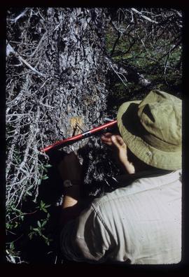
Image depicts a man, most likely Kent Sedgwick, using what appears to be some type of a spigot on a tree.
Image depicts mountains, taken from the river channel leading to the Spectacle Lakes.
Image depicts a mountain in the distance, and the river channel leading to the Spectacle Lakes.
Image depicts the river channel leading to the Spectacle Lakes.
Image depicts Spectacle Lake.
Image depicts Southbank, B.C.
Image depicts an aerial view of what is likely Turner Lake in South Tweedsmuir Provincial Park.
Image depicts an aerial view of South Tweedsmuir Provincial Park. The lake is possibly Lonesome Lake.
Image depicts an aerial view of a lake in South Tweedsmuir Provincial Park. It is possibly Lonesome Lake.
Image depicts an aerial view of Glacier Mountain in South Tweedsmuir Provincial Park.
Image depicts an aerial view of what is likely Glacier Mountain in South Tweedsmuir Provincial Park. The two lakes present are possibly Vista and Junker.
Image depicts an aerial view of a "glaciated valley" in South Tweedsmuir Provincial Park. Glacier Mountain is present in the image.
Image depicts an aerial view of a chain of lakes in South Tweedsmuir Provincial Park.
Image depicts an aerial view of South Tweedsmuir Provincial Park.
Image depicts a view of South Tweedsmuir Provincial Park.
Image depicts an aerial view of South Tweedsmuir Provincial Park.
Image depicts a lake and mountain somewhere in South Tweedsmuir Provincial Park.
Image depicts an aerial view of a lake in South Tweedsmuir Provincial Park.
Image depicts an aerial view of South Tweedsmuir Provincial Park.
Image depicts a view of South Tweedsmuir Provincial Park. An unidentified man stands on the side of the image.
Image depicts a cemetery in the South Fort George suburb of Prince George, B.C.
Image depicts the cutbanks of the Fraser River at Soda Creek, B.C.
Image depicts a section of land, with a few houses, in Soda Creek, B.C.
Image depicts an old building located somewhere are the Pickard farm north of Soda Creek, B.C.
Image depicts the old jail house in Soda Creek, B.C.
Image depicts the old community hall in Soda Creek, B.C.
Image depicts the cemetery in Soda Creek, B.C.
Image depicts rail road tracks through a forest, as well as a river; located in Soda Creek, B.C.
Image depicts a forest and river in Soda Creek, B.C.
Image depicts a road covered in snow running through the woods at an uncertain location.
Image depicts a snowy road at an uncertain location.
Image depicts Snowpeak above Longsworth B.C.
Image depicts an unidentified individual setting up some sort of pole in the snow for a process the slide labels as "snow sounding." The location is uncertain.
Image depicts a snow gauge at an uncertain location.
Image depicts a view of the scenery between Smithers and Telkwa, B.C.
Image depicts a mountain in Smithers, B.C.
Image depicts a view of what appears to be a small town at an uncertain location.
Image depicts a river at an uncertain location in either the Lillooet or Kamloops area.
Image depicts a small mountain at an unknown location. The slide is labelled "basalt" for an unknown reason.