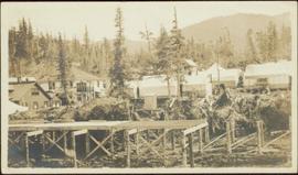
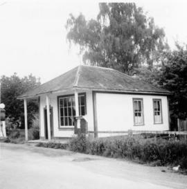
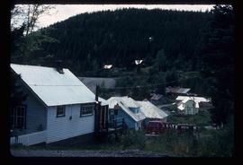
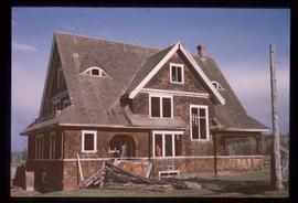
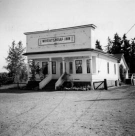
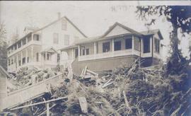
Photograph depicts the Wheatsheaf Inn "pub" on the way to Cedar-by-the-Sea from Nanaimo, B.C.
Warf construction visible in foreground. Background consists of a few built structures and several tents, location unidentified.
Photograph depicts a wharf at Sechelt village on the Sechelt Peninsula. The view is looking southeast towards Vancouver.
Photograph depicts a wharf at Lang Bay, 14 miles southeast of Powell River. In fair repair, now used only by an oil company to pump in oil to a storage depot behind the camera.
Photograph depicts a wharf and buildings along the shore of an unidentified fishing community with a forested environment visible in the background.
Photograph depicts the Westholme post office.
Photograph depicts the Westbridge CPR depot on the Kettle Valley Line. It is located about 11 miles north of Rock Creek and at about mile 123.3 east of Penticton. The depot house is disused and the sidings contained no cars, so there appears to be no local traffic.
Handwritten annotation on recto of photograph: "FOOTING WEST WALL AUG 8/64." Photograph depicts a construction worker near freshly poured cement footings. Building is semi-visible in background on left, tall steel framework behind footings on right. The hard had of a second worker is visible behind footings.
Handwritten annotation on recto of photograph: "WEST WALL FOOTING AUG 8/64." Photograph depicts a construction worker standing on rebar in forms built for cement footings. A front end loader and backhoe tractor can be seen on wood platform above footings. Mountainside in background.
Photograph depicts the West Summerland CPR station in the Okanagan. The station often was used but not permanently manned. It was located at mile 9.5 from Penticton. The view is looking south.
Photograph depicts West Coast Electric Ltd., an electric manufacturers and shop.
Image depicts the Wells Museum in Wells, B.C.
Image depicts the Wells Hotel in Wells, B.C.
Image depicts a crowd of people outside the Wells Hotel in Wells, B.C.
Photograph depicts the old hospital building in Wells. At the time the photo was taken, 1978, it was being used as an apartment building, and that is still its current use.
Image depicts Wells, B.C.
File contains slides depicting Wells, B.C.
Image depicts Wells, B.C.
File contains slides depicting weather balloons.
Group stands and sits on front steps of rectory. Left to right: Rev. William Edwin Collison, Mabel and John Maxwell Collison, Alice Collison. (William, Max, and Alice are sons and daughter of Archdeacon W.H. Collison).
Handwritten annotation on verso reads: "Dad & Auntie Al with Aunt May & Uncle Max at the rectory St. Luke's church [...?]".
Archdeacon W.H. Collison and an unidentified man on the "Dawn," Collison's boat. Forested hills and several buildings are visible in the background. Handwritten annotation on verso reads: "The 'Dawn' Archdeacon Collison's boat."
Rev. W.E. Collison sits to left of totem pole, smoking a pipe (oldest son of Marion and Archdeacon W.H. Collison). Log fence can be seen in front of forest in right background.
Handwritten annotations on verso read: “W.E. Collison at Massett, QCIs."; "Dad beside totem pole".
Image depicts the Watson Mansion at Mile 108 of Highway 97. It was built by Captain Geoffrey Watson in 1904, and was burned down by a chimney fire in 1983.
Image depicts the Watson Mansion.
Wide angle view of Prince Rupert harbour taken from the water. Forest and mountains are visible in the background. Annotation on recto reads: "Prince Rupert BC '07."
Photograph depicts a working undershot water wheel on Lardeau Creek River. It was the only water wheel seen in B.C. between 1963 and 1970. It was designed to drive an electricity generating set, but it was not coupelled to the set at the time.
Photograph depicts an abandoned water tower on CPR line at Brookmere, 30 miles south of Merritt. The trackage on the right has had the spikes removed but the yard consists of a mixture of completely removed, partially removed, and completely undisturbed track. An elderly couple and 2 elderly bachelors are the only year-round remaining inhabitants.
Photograph depicts the water tower at the C.P.R. Savona Depot. The view is looking east towards Kamloops.
Photograph depicts a surviving but disused water tower at Cranbrook. Cranbrook is located at mile 0 on the CPR line of the Nelson Subdivision.
Photograph depicts the water tower at B.C. Forest Products Ltd. Mill at Port Hammond, in the Fraser Valley.
Photograph depicts a full but unused water tank at Duncan Station on the Esquimalt and Nanaimo Railway on Vancouver Island.
File contains 3 strips of negatives depicting water control structures inluding pipes, culverts, and holding ponds. The strips were found in a photo lab pouch annotated "Sedimentation Pond Sept 1991" and addressed to "Cassiar Mining Corp. Attn; R. Tyne."
Photograph depicts the washrooms on the west side of the line, about a quarter mile from the McCulloch CPR depot building. The depot is located at mile 76.6 on the Carmi Subdivision.
The item is a photograph reprint originally taken between 1967 and 1975. The photograph depicts Prince George's war memorial cenotaph in front of City Hall. The address is 1100 Patricia Boulevard
Photograph depicts a walkway under construction leading to a house on top of a hill. In the foreground of the image there is forest debris and in the background another large house is visible.
Handwritten annotation on recto of photograph: "Omineca Dist Walcott Suspension Bridge West Approach - looking East May 26 - 1932". Photograph depicts two white horses pulling a wagon in front of Walcott bridge. This bridge was moved from its original location in the Hagwilget Canyon, downstream from Walcott on the Bulkley River. It is a pedestrian bridge at the time of this photograph, though it was originally used by motor vehicles. Dirt road leading to bridge in foreground, with lumber and brush piles on either side. Trees and hills on opposite shore in background.
Item is a photograph of construction of the W.A.C. Bennett Dam.
Image depicts the W.A.C. Bennett Dam on the Peace River in Hudson's Hope, B.C.
Item is a photograph of the Bennett Dam.
Image depicts several unidentified individuals lying on a hill outside what is most likely the W.A.C. Bennett Dam in Hudson's Hope, B.C.
Photograph depicts Wabco in left foreground in front of shop building, tractor, and miscellaneous supplies. Mine valley and mountains in background. Handwritten annotation on recto of photograph: "Cassiar B.C. 1970 June 23 by Tom Kiefer".
The item is a photograph of W. D. West foto source on 3rd Avenue in Prince George.
Virginia (nee Taylor) stands in long jacket, scarf, hat, and gloves, on smooth road. Behind her lies a groomed area with palm trees and ferns enclosed by rope fence. A large, stately building with detailed arches stands in background.
Violet (nee Taylor) Baxter and Ellen (nee Taylor) Garland stand wearing formal attire in dirt area. A lumber pile and unidentified man can be seen behind a fence that crosses the midground. Power poles and other buildings in background.