File consists of photocopied maps of Island Cache (Cottonwood Island) and Prince George.
Item is a marking manual compiled by D.R. Glew, Assistant Forester.
Item is an original issue of British Columbia Forest Service Research Notes on "Marking of Spruce in the Fort George Forest District" by L.A. deGrace, E.W. Robinson, and J.H.G. Smith.
Item is "Memorandum regarding Future Logging at Aleza Lake" by F.S. McKinnon.
File consists of a panel moderation talk given by Gary Runka entitled "Methods of Resolving Land Use Conflicts in BC".
"Mineralogy of clay and sand fractions of soils developed from till, glaciofluvial and glaciolacustrine deposits in central interior British Columbia" was a preliminary internal report that provides some background to Arocena and Sanborn's regional soil mineralogy study, as well as a compilation of the mineralogical data.
The key results from this work were later published as:
J.M. Arocena and P. Sanborn. 1999. Mineralogy and genesis of selected soils and their implications for forest management in central and northeastern British Columbia. Canadian Journal of Soil Science 79: 571-592. https://doi.org/10.4141/S98-07
This Ministry of Forests internal memorandum of 30 June 1997 from Paul Sanborn to Regional & Research Branch soil scientists provides comparison of Morgan's extractant and BaCl₂ for cations, using the 57 samples from the regional soil mineralogy study.
The key results from the study were later published as:
J.M. Arocena and P. Sanborn. 1999. Mineralogy and genesis of selected soils and their implications for forest management in central and northeastern British Columbia. Canadian Journal of Soil Science 79: 571-592. https://doi.org/10.4141/S98-07
File contains listing of items donated by Rose Margaret Davies to the Ridley Home Archives in 2008 that documented accomplishments of Margaret West; handwritten notes regarding place names along the North Pacific Coast and one page from an issue of the Monthly Reporter, No. 9, September 1873 published by the Church Missionary Society.
The Miscellaneous Forest History Material series consists of material created or used by various logging and pulp mill companies. Includes forms, union materials, maps, plans and other records related to the forestry sector in British Columbia. The series also comprises publications related to equipment and employee training, and correspondence and memorandum developed by B.C. Chemicals, a division of Canfor.
File consists of office files containing individual copies of General Orders # 311-317; records related to BC Police Training School 1937; Calvary Drill instruction; an additional copy of Index to General Orders Nos. 1 – 271; and short histories of the BC Provincial Police.
This series consists of material created by various societies, companies, railways, unions and government branches for the use and instruction of railway companies and employees. Includes publications, time tables, training materials, union materials, forms, maps and plans related to rail operations in North and South America, but predominately related to Canadian railway operations. Also comprises material created by several American and Canadian railways and transportation companies.
Document prepared by P. Grilz contains species lists and UTM coordinates for 10 sampling locations for the M-K-2001-2002-81 Seed Project.
Item is an original "Mount Edziza Park Wildlife Report: An Argument for Nature Conservancy Status" report by W.G. Hazelwood, Parks Biologist. Includes original photographic prints pasted into the report. Also includes an accompanying "Mt. Edziza Wildlife Survey" from October 13, 1979.
Item is a photocopied "Mountain Goat Surveys in the Tatlatui, Spatsizi and Mt. Edziza Provincial Park Areas, British Columbia" report by David F. Hatler (Wildeor) and W.G. Hazelwood (Alpenglow Resources).
Item is an original report by Grant Hazelwood entitled "Mt. Assiniboine Park Trip, August 19-22, 1974". Includes original print photographs pasted into the report. The objective was to sample the lakes fishery at the south and north ends of the park and to examine some grizzly bear habitat on the Simpson River and examine the condition of guiding cabins in the same area.
Item is a photocopied excerpt from an issue of "The Forestry Chronicle" entitled "Natural Reproduction Following Fires in Central British Columbia" by E.H. Garman.
This document is an unpublished draft manuscript of a Northern British Columbia history annotated bibliography. The document is based overwhelmingly on research into secondary sources published prior to 2016; more recent sources are not included. The annotated bibliography includes the following sections:
- Historiography
- Settlement Histories
- Alexander Begg's History of British Columbia
- R.E. Gosnell
- E.O.S. Scholefield
- Regional History
- New Histories
- Environment
- Northern History
- Ancient History
- Bibliography
Item is a poorly photocopied version of Percy Barr's "Northern Interior Forest Experiment Station Progress Report". Location of original is unknown.
Item is an original "Northern Interior Forest Experiment Station: Report of Preliminary Investigations" by Percy Barr. Includes original photographic prints.
Item consists of a summary document entitled "Notable Surveys" by Mrs. W.K. Rutherford, V.C. Brink, R.S. Silver, and M.Z. ("Smokey") Neighbour. The document summarizes Knox McCusker's notable surveys. This article may have been put together by the authors for, or in conjunction with, a submission to a historical serial publication.
File consists of notes written by Joan Sawicki for an untitled pending speech by Gary Runka.
Commentary on this speech by Barry Smith of the Ministry of Agriculture and Lands:
"Despite this being only 4 pages of rough notes, its focus on the initial work of the Commission and challenges of designating the ALR make it an historically important document.
For example it was initially thought the ALR would be guided by class 1 - 4 CLI ratings but this proved impractical in the north and range areas. An additional challenge was that parts of the province only had the benefit of 1:50000 mapping. This presented a very real problem for establishing the ALR.
One concern with this document is that because it is written in point form and consists of rough notes, it could be open to a degree of misinterpretation if not considered by an individual with experience in the administration of the ALR. For a much more refined statement on the B.C. Agricultural Land Preservation program and the designation of the ALR see Items [2020.4.2.1.23, 2020.4.2.1.24, and 2020.4.2.1.25]."
Item is a photocopied report by Don Miller entitled "Observations of Caribou and Caribou Environment in Northern and Southern Tweedsmuir Park and Wells Gray Park in Summer of 1977 with Comments on Related Observations in Spatsizi Park during Spring".
File consists of an official regional park plan for the Regional District of Fraser-Fort George.
File contains 1998 proposals and other correspondence between the Ministry of Forests and the Aleza Lake Steering Committee regarding the future management of the Aleza Lake Research Forest.
File consists of the following original items:
- Letter to G.G. Aitken from K.F. McCusker (Jan. 9, 1934)
- Letter to G.G. Aitken from K.F. McCusker (June 20, 1934)
- Letter to G.G. Aitken from K.F. McCusker (May. 9, 1938)
- Certificate no. 484 bestowed upon Knox Freeman McCusker enabling him to be admitted as an Articled Pupil with the Dominion Lands Surveyors. (Feb. 22, 1909)
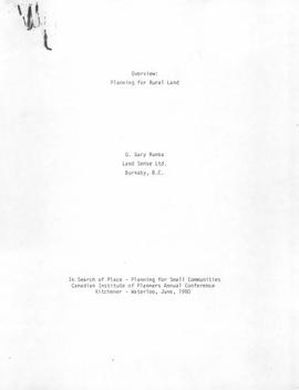
File consists of a speech given by Gary Runka entitled "Overview: Planning for Rural Land" for the Canadian Institute of Planners Annual Conference in Kitchener, Waterloo. Includes newspaper clipping titled "A pathetic tale of two resources" from the Victoria Colonist, June 22,1980.
Commentary on this speech by Barry Smith of the Ministry of Agriculture and Lands:
"This speech is aimed at the "urban" planner who is planning in rural areas. While 'rural land' can encompass many things and there are only passing references to agriculture, the planning approaches and principles - like the need for the urban planner to view the world from the rural side of the fence - is often going to involve agricultural land.
Mention is made of integrated natural resource management and an emphasis is made on the planner understanding the rural perspective.
The comment (warning) is made that "...the rural land use tug-of-war between lifestyle pursuits, population demands and natural resource production will continue" - the message being that planning practitioners will probably find themselves in the midst of these tug-of-wars.
This paper clearly recognizes the challenges of introducing urban planning techniques into rural landscapes and provides some very valuable insights. While farmland preservation isn't central to this speech the rural resource and planning theme is relevant."
Pacific Great Eastern Railway series consists of correspondence between departments, records pertaining to train movements, and ephemera. Series includes publications concerning the topics of unionized labour, railway operation, and public interest. Also consists of maps and technical drawings depicting Pacific Great Eastern Railway lines and structures.
Pacific Great Eastern RailwayFile consists of maps of the Pacific Great Eastern (PGE) and BC Rail (BCR) trackage in British Columbia, which consist of photocopy reproductions and hand drawn works by Davies. Includes maps of PGE/BCR track in various B.C. cities (Fort St. John, Chetwynd, Dawson Creek, Squamish, 100 Mile House, Lillooet, Fort Nelson, Williams Lake, West Vancouver, Quesnel); maps of PGE/BCR track at various times (1973, 1986); and maps of the Dease Lake extension.
This born-digital document is an unpublished report to the Geological Survey of Canada on field work data and interpretations of Inlin Brook paleosols.
As part of a multidisciplinary team led by Grant Zazula (then a Ph.D. student at Simon Fraser University; later a palaeontologist with the Government of Yukon) and Duane Froese (Professor, University of Alberta), Dr. Paul Sanborn examined a set of buried paleosols (fossil soils) preserved in frozen sediments exposed by placer mining in the spring of 2004.
The findings were published in:
Zazula, G.D., D.G. Froese, S.A. Elias, S. Kuzmina, C. La Farge, A.V. Reyes, P.T. Sanborn, C.E. Schweger, C.A.S. Smith, and R.W. Mathewes. 2006. Vegetation buried under Dawson tephra (25,300 14C yr BP) and locally diverse late Pleistocene paleoenvironments of Goldbottom Creek, Yukon, Canada. Palaeogeography, Palaeoclimatology, Palaeoecology 242: 253–286.
https://doi.org/10.1016/j.palaeo.2006.06.005
The Lost Chicken Mine, a placer gold mine in eastern Alaska, approximately 120 km west of Dawson City, Yukon, is an important fossil locality for the late Pliocene (approximately 2.5 – 3.0 million years ago). A comprehensive account of the stratigraphy and paleontology of this site was given by:
Matthews, J.V., Jr., J.A. Westgate, L. Ovenden, L.D. Carter, and T. Fouch. 2003. Stratigraphy, fossils, and age of sediments at the upper pit of the Lost Chicken gold mine: new information on the late Pliocene environment of east central Alaska. Quaternary Research 60: 9-18. https://doi.org/10.1016/S0033-5894(03)00087-5
Dr. Paul Sanborn visited the site on July 20, 2004, as part of a group led by Duane Froese (Professor, University of Alberta). The group concentrated on a single exposure (~ 2 m thick) straddling the Lost Chicken tephra, a volcanic ash bed (2.9 ± 0.4 myr) which is a major stratigraphic marker at the site. Sanborn described, photographed, and sampled this exposure, and obtained a basic set of characterization data. Intact samples were collected but thin sections were never produced.
File consists of assorted maps, correspondence, and speeches examining the prospects of park establishment in the Prince George area.
File consists of selected personal records from Dr. Joselito Arocena's digital media. Includes 3 floppies and migrated data from hard drives.
File consists of the written personal reflections of Gary Runka for the "'Ten Years of Agricultural Land Preservation", December 1983.
Commentary on this speech by Barry Smith of the Ministry of Agriculture and Lands:
"These personal reflections were prepared by GGR for publication in the ALC's document commemorating its 10th anniversary entitled "Ten Years of Agricultural Land Preservation". These reflections form pages 33 - 35 of this 61 page document.
The reflections portray the hectic start of the Land Commission's work but also inform us of GGR's role prior to becoming the Commission's first General Manager. As noted, "I had been extensively involved in drawing up the "suggested ALR plans" for the various regional districts while working with the Soils Branch of the Ministry of Agriculture." He then accompanied the Commission on their initial meetings with regional districts and local governments around the province.
The fact that GGR played a key role in developing the CLI mapping (an important basis of the ALR), then was involved with drawing up the suggested ALR plans, followed by his efforts as ALC General Manager to implement the Reserve plans, and finally sign off on the completed ALR plan map sheets, arguably makes Gary Runka, like no other person, the "Father of the ALR"."
- Agreement of Sale of Prince George Citizen
- Correspondence regarding proposed Prince George Citizen sale – H.G.T. Perry & news clippings
File consists of a speech given by Gary Runka entitled "Physical Resource Data Needs in Land Use Planning" which was given at a technical workshop to develop an integrated approach to base data inventories for Canada's Northland.
Commentary on this speech by Barry Smith of the Ministry of Agriculture and Lands:
"While the speech is not related to agriculture or farmland preservation directly, GGR emphasises the importance of data collection and mapping and its use in the planning process. The general principles he discusses were those employed in the development of the Agricultural Land Reserve.
The proceedings of the workshop were published in 1979 by Environment Canada." The proceedings are available online at: https://www.geostrategis.com/PDF/1974-04-17%20remote%20sensing%20for%20northen%20surveys%20and%20environmental%20monitoring-jean%20Thie%20CCRS%20copy.pdf
Map depicts the Shuswap Lakes, Rogers Pass, Kamloops, Yellowhead Pass, Thompson Valley, and the Nicola Valley. Also includes the first clues to a treasure hunt.
File consists of a speech given by Gary Runka to the BC Federation of Labour Environmental Conference entitled "Planned Development and Land Conservation".
Commentary on this speech by Barry Smith of the Ministry of Agriculture and Lands:
"GGR discusses the 'problem' of land being considered as either an "ecological natural resource" or "hot commodity".
He mentions that his background is in the natural sciences and land use planning and prefers to look at land as an ecological resource, not simply as a commodity.
The speech includes a quick review of the Land Commission's work and with reference to the Land Commission Act he makes the following observation (p.2):
"...the purpose is hardly necessary to relate to you - as what animal survives that destroys his food habitat next to his shelter or cover?"
The reason for BC's farmland preservation program could hardly be better stated."
File consists of a speech given by Gary Runka entitled "Planning for the Future Agricultural Land Base of Alberta" for Alberta Agriculture Land Use Activities, Edmonton, June 2,1981.
Commentary on this speech by Barry Smith of the Ministry of Agriculture and Lands:
"This appears to be a set of preliminary speaking notes - much of it is point form with considerable hand written notes in the margins. It is not known if these notes were ever finalized into the speech given on June 2,1981 or if the speech was simply given using these notes as its basis.
Many of the references are somewhat oblique relating to topical matters in Alberta. While agriculture is the central theme, this speech is focused on Alberta with little or no reference to the BC farmland preservation program.
Several broader themes are considered which are dealt with in other speeches but GGR speaks to the longer term importance of farmland preservation legislation when stating (p. 3):
"b) from my experience, time is demonstrating ever more clearly to me that, for a variety of reasons, legislating land preservation alone can only hold the land resource for so long if the other aspects affecting the food producing industry are not also given attention e.g.:
- review of regional planning by the ARB
- costs of production and marketing opportunities
- gov't priority for ag. related to other prov. resources
- urban planning - where are the cites going?
- rural planning - how secure are the rural communities of which agriculture is a part?"
File consists of an article written by Gary Runka entitled "Political Realities - Protecting our Dwindling Soil Resource". This was published "Agrologist" magazine (Fall 1980) as "Protecting the soil".
Commentary on this speech by Barry Smith of the Ministry of Agriculture and Lands:
"This paper is focused on the importance of soil conservation. It makes the observation that soil erosion is often not recognized until the damage has been done, but it takes even longer for politicians to be aware of the problem and then for this to translate into policy change. It is noted that this is especially a problem given the short term time horizons of politicians. There is a discussion of what jurisdiction is best to deal with protecting the soil resource. It is emphasized that we no longer have the luxury of time."
File contains original study data for Plot 102, and includes handwritten charts, tables and diagrams.
File contains photocopied measurement tables, handwritten ledger pages, and a photocopied report for plot 103.
File contains original study, measurements, and charts of plot 104.
File contains original study, charts, and measurements of plot 105.
File contains photocopies of data sheets and charts, handwritten ledger pages, and a photocopied study of plot 106.
File contains photocopied study, handwritten loose ledger pages, and photocopied data sheets for plot 107.
File contains handwritten notes, original diagrams, charts, studies, and black and white photos relating to Plot 108.
File contains handwritten germination summaries and measurements, charts, and the original study relating to Plot 111.
File contains photocopies of original study, loose handwritten ledger notes, and measurement charts relating to Plots 112 and 113.