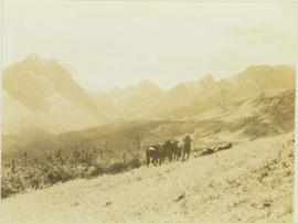
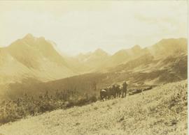
Photograph depicts three unidentified crew men searching for game through binoculars while their horses stand by. In the background a forested valley surrounded by a mountain range is visible.
Photograph depicts three unidentified crew members seated under a canvas tarp in forested area.
Image depicts a view of the scenery, with three hikers in the bottom left corner of the image.
Image depicts three men and a dog on the hiking trail near Mt. Robson.
Photograph depicts three men at a whaling station with debris on the ground and a large elevated tank in the background.
Photograph depicts three men fishing in a boat with a cannery and wooden buildings along the forested shoreline in the background.
Photograph depicts three men standing in dirt area near fire wood. Tent building semi-visible on left, forest trees behind snow pile in background. Handwritten annotation on recto of photograph: "Relief camp at Penny. 100 men - A.K. Bourchier Foreman - Dixon Taylor timekeeper. [Ted Nevan?] purchasing agent - hungry thirties. Construction days. Mile 29 - A.K. Bourchier J.P." Man in middle is believed to be A.K. Bourchier.
Image depicts three unknown individuals at a campsite.
Image depicts two individuals seated at a picnic table while a third stands closer to the water on a beach somewhere in Kitimat, B.C. What appears to be a harbour can be seen on the water.
Image depicts three individuals and three dogs standing by a stream at an uncertain location, possibly somewhere in Bear Glacier Provincial Park. The woman in purple is possibly Sue Sedgwick.
Image depicts three picnic tables, one of which is occupied with three unknown individuals, on a beach somewhere in Kitimat, B.C.
Photograph depicts two small children standing with snowshoes in front of wolf pelts hung from a pole in snow-cleared area, miscellaneous items throughout. Forest in background. Typed annotation on recto of photograph: "Wolf pelts, taken at Teslin Lake B.C." See also items 2009.5.2.66 & 2009.5.2.67.
File contains slides depicting places along the Skeena River on the way to Prince Rupert, B.C.
Image depicts a woman standing in a field, with a sign in a tree behind her pointing the way towards the Raven Cabin.
Image depicts an old tomb stone at an uncertain location, possibly Fort St. James, B.C.
Image depicts the tombstone of T.J. Menefee in the cemetery in Soda Creek, B.C.
Photograph depicts the craggy top of a mountain peak situated above an alpine lake. The location of the photograph is the Mt. Petrie area from the north and northwest.
Photograph depicts the top of a mountain ridge situated next to an alpine lake. The photograph location is the Mt. Petrie area from the north and northwest.
Photograph depicts a top view of an extensive mountain range with snow-covered peaks.
File consists of miscellaneous reports, research material, memoranda and correspondence related to Total Gas Pressure (TGP) research and/or flow analysis research. Includes copies of the following reports: "Effect of Elevated Water Temperatures on Infectious Diseases of Salmonids, Particularly Chinook Salmon" by G.R. Bell; and "Experience in Michigan with Gas Supersaturation" by Harry Westers.
File consists of miscellaneous reports, research material, memoranda and correspondence related to Total Gas Pressure (TGP) research and/or flow analysis research. Includes copies of the following reports: "Precis on Total Gas Pressure Research" by D.F. Alderdice and J.O.T. Jensen; "Environmental Studies Associated with the Proposed Kemano Completion Hydroelectric Development: Volume 2, Physical and Hydrological Studies" prepared by Envirocon Ltd.; and "Statement on the Significance of Excess Total Dissolved Gas Pressure to Juvenile Salmonids" by D.F. Alderdice.
File consists of miscellaneous reports, research material, memoranda and correspondence related to Total Gas Pressure (TGP) research and/or flow analysis research. Includes copies of the following reports: "Influence of Atmospheric Gas Supersaturation on Salmonid Fishes in Relation to Manipulation of the Nechako River through the Kemano Completion Project" by D.F. Alderdice and J.O.T. Jensen; "Synopsis of 1985 Nechako River Salmonid Gas Bubble Trauma Field Studies"; and a proposal submitted to DFO Fisheries Research Branch to study the "Establishment of Total Gas Pressure Criteria for Salmonid Fishes Exposed to Gas Supersaturation in Water" by Don Alderdice and John Jensen.
File consists of miscellaneous reports, research material, memoranda and correspondence related to Total Gas Pressure (TGP) research and/or flow analysis research. Includes memoranda regarding the DFO's position on Nechako River fish flow requirements and a statement by Jorgen O.T. Jensen for the Nechako court case on "Assessment of the Influence of Excess Total Gas Pressure (TGP) on Salmonids in the Nechako River.
Image depicts a totem pole at an uncertain location, possibly in Gitwinksihlkw, B.C.
Image depicts several individuals examining totem poles which are possibly undergoing a restoration process somewhere on Haida Gwaii.
Image depicts a view of the scenery at an uncertain location with numerous individuals, possibly tourists, present. It is possibly somewhere near the Fraser River.
Image depicts a view of the landscape at an unknown location with a group of people, possibly tourists, present. It is possibly near the Fraser River.
Photograph depicts a tug boat hauling a line of small fishing boats across the water with a mountain in the background. Annotation on verso of photograph states: "Tow of Cannery Fishing boats"
File consists of an original copy of DFO's "Toward a Fish Habitat Decision on the Kemano Completion Project: A Discussion Paper", with annotations by Shirvell. Includes accompanying errata, Shirvell's notes, a news release about the publication, and a summary of the report by the International Pacific Salmon Fisheries Commission entitled "Potential Effects of the Kemano Completion Project on Fraser River Sockeye and Pink Salmon".
File consists of an original copy of "Toward a Fish Habitat Management Policy for the Department of Fisheries and Oceans: A Response from the United Fishermen and Allied Workers Union".
Photograph depicts horse and rope in Fraser River. Hill on opposite shore in background.
Photograph depicts the Cassiar valley: town in foreground, plant and tailings pile behind. Mine road can be seen from plant to mine valley on left. Mountain range in background.
Photograph depicts the Cassiar valley: town in foreground, plant and tailings pile in background.
Photograph depicts the Cassiar valley: town in left foreground, plant and tailings pile in midground, mountains in background. Photograph was taken from the air, portion of plane visible in top left of image.
Photograph depicts the Cassiar valley: town on left, plant and tailings pile on right, mountains in background. Mine road can be seen from plant to mine valley in top left of image.
Photograph depicts the Cassiar valley: town in foreground, plant and tailings pile in background. Mountain range visible in distance. Photograph was taken from above, facing east.
Photograph depicts the Cassiar valley: plant and tailings pile on left, town on right. Mountain range visible in distance. Photograph was taken from above, facing south.
Photograph depicts the town of Cassiar behind plant buildings in left foreground. Mountain base in background. Photograph was taken from the air, portion of plane visible in top left of image.
Photograph depicts the town of Cassiar, mountain base in background. Mine road visible in top right of image.
Photograph depicts the Cassiar valley: town on left, plant on right, mine valley in background. Photograph was taken from above, facing north east.
Photograph depicts the town of Cassiar behind plant and tailings pile in foreground. Mountain range in background.
Photograph depicts the town of Cassiar, mountain base in background.
Photograph depicts the town of Cassiar in foreground, mountain base in background. Photograph was taken from the air, portion of plane visible in top left of image.
Photograph depicts the Cassiar townsite in foreground. Mill, dry rock storage building, and tailings pile can be seen in background. Handwritten annotation on verso of photograph: "1958 [1961 crossed through]."
Photograph depicts the Cassiar plantsite including the mill, dry rock storage building, tailings pile, and many other buildings. A portion of the townsite can be seen on left.