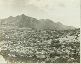
Mill building in left midground. Conveyor believed to be leading to tailings pile can be seen in foreground. Valley and mountains in background.
Photograph depicts a shovel loading what appears to be a Euclid ore haulage truck in excavation area of mine.
Image depicts Kent Sedgwick standing beside a wrecked plane somewhere in South Tweedsmuir Provincial Park.
Image depicts an unknown individual pointing at some writing on a rock; it possibly reads "ACC Aug 10 1911."
Photograph taken at Government House in Victoria, B.C.
Image depicts a field of yellow plants at an uncertain location.
Image depicts the Fraser River and the Yellowhead and Grand Trunk Railway Bridges from LC Gunn Park. Map coordinates 53°54'30.7"N 122°43'27.0"W
Image depicts the Yellowhead Bridge across the Fraser River. Map coordinates 53°54'45.2"N 122°43'27.9"W
Image depicts Yellowhead Lake, located near the Yellowhead Pass.
Image depicts a view of what is possibly the Yellowhead Pass on the British Columbia-Alberta border, west of Jasper A.B.
Image depicts the boundary line between British Columbia and Alberta at the Yellowhead Pass.
Photograph depicts a young caribou visible in the distance standing on a rocky mountain slope. In the background a mountain range is visible.
Photograph depicts a young child petting a small fawn surrounded by lush greenery.