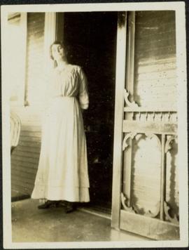
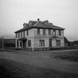
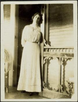
Woman speculated to be mother of H.F. Glassey stands in open doorway of porch, leaning her head against the sill.
Woman stands wearing hat and fur coat in front of bus. Street, man, woman, and large building visible in background.
Image depicts a woman, wearing clothes reminiscent of traditional First Nations, who appears to be dancing in the street outside of a Native Friendship Centre in Prince George, B.C. A large crowd is looking on.
Unidentified woman stands by hedges in front of tall home with covered veranda and pillared entry way. Sidewalk and front lawn in foreground, shed in background.
Unidentified woman stands on sidewalk in front of large home with pillared entryway and veranda.
Photograph speculated to depict Sarah Glassey in a warm location such as Los Angeles, California. Large building with tiled roof stands in background, cars in right foreground.
Woman and baby stand on front lawn, unknown man and building in background.
Woman and baby stand in grassy area of what appears to be a farm yard, unidentified buildings in background.
Image depicts the old community hall located somewhere in the Wistaria Provincial Park.
Photograph depicts village buildings along shore.
Handwritten annotation on verso reads: "Massett in Winter dress."
Handwritten annotation in pen on verso reads: “Looking out of our classroom window up the street.” According to the donor, the car stuck in the snow belonged to his colleague, Bob White.
Elevated photograph of downtown Prince Rupert covered in snow. Printed annotation on recto reads: "Winter Scene. Prince Rupert. B.C."
Photograph is a printed postcard depicting a few cabins covered in snow near Stewart B.C.
Photograph depicts Windsor School, an elementary school in south Burnaby.
Photograph depicts Windsor Hotel, the only survivor of about 5 hotels that were in the area.
Photograph depicts the Windsor Hotel at Fort Steele, 10 miles northeast of Cranbrook. It was built in 1895 by Robert D. Mather and originally was called Dalgarno House. It is being renovated as a village museum.
Image depicts a snowy street in Willow River, B.C. There are several buildings, one is an Esso station and another is labelled as "Red & White Food Store."
Image depicts a snowy street in Willow River, B.C. with a row of houses. The white building on the end with the Pepsi sign is the Willow River General Store. Map coordinates 54°04'18.3"N 122°28'14.7"W
Image depicts a playground in Willow River, B.C. The slide labels it as being a "former hotel site." Map coordinates 54°04'23.7"N 122°28'26.9"W
Image depicts the cableway in Willow River, B.C.
Image depicts the cableway, stretching over a river, in Willow River, B.C.
Image depicts the cableway in Willow River, B.C.
Image depicts the St. Joseph's Mission in Williams Lake, B.C.
Image depicts an aerial view of Williams Lake, B.C.
Image depicts a view of Williams Lake, B.C.
Image depicts an aerial view of Williams Lake, B.C.
Rock pile, unknown building, and hills can be seen in background.
Photograph is one of 11 images taken during a World Health Organization (WHO) trip, Human Rights of Women and Children, Peru, 1990. Possibly affiliated with World Council of Churches, International Ecumenical Delegation to Lima, Peru, 14-25 October 1990. See also items 2009.6.1.505 - 2009.6.1.515.
Vehicles and large cement building in background.
Photograph is one of 11 images taken during a World Health Organization (WHO) trip, Human Rights of Women and Children, Peru, 1990. Possibly affiliated with World Council of Churches, International Ecumenical Delegation to Lima, Peru, 14-25 October 1990. See also items 2009.6.1.505 - 2009.6.1.515.
The group stands in front of a cement building.
Photograph is one of 11 images taken during a World Health Organization (WHO) trip, Human Rights of Women and Children, Peru, 1990. Possibly affiliated with World Council of Churches, International Ecumenical Delegation to Lima, Peru, 14-25 October 1990. See also items 2009.6.1.505 - 2009.6.1.515.
The group stands in front of a brick wall.
Photograph is one of 11 images taken during a World Health Organization (WHO) trip, Human Rights of Women and Children, Peru, 1990. Possibly affiliated with World Council of Churches, International Ecumenical Delegation to Lima, Peru, 14-25 October 1990. See also items 2009.6.1.505 - 2009.6.1.515.
Trees in foreground, hills in background. Unidentified man stands on far left.
Photograph is one of 11 images taken during a World Health Organization (WHO) trip, Human Rights of Women and Children, Peru, 1990. Possibly affiliated with World Council of Churches, International Ecumenical Delegation to Lima, Peru, 14-25 October 1990. See also items 2009.6.1.505 - 2009.6.1.515.
Unidentified individuals can be seen walking and sitting behind arches. One man lies on street in foreground.
Photograph is one of 11 images taken during a World Health Organization (WHO) trip, Human Rights of Women and Children, Peru, 1990. Possibly affiliated with World Council of Churches, International Ecumenical Delegation to Lima, Peru, 14-25 October 1990. See also items 2009.6.1.505 - 2009.6.1.515.
Image depicts the White Pass Train crossing over a railway bridge at an uncertain location.
Image depicts the White Pass Train crossing over a railway bridge at an uncertain location in the mountains.
Image depicts the White Pass Train crossing over a railway bridge at an uncertain location.
Image depicts a sign, labelled "The White Pass Snow Fleet," which details the history of the fleet; it is located in Skagway, Alaska.
Image depicts a grave somewhere along the White Pass railway.
Photograph depicts the Wheatsheaf Inn "pub" on the way to Cedar-by-the-Sea from Nanaimo, B.C.
Warf construction visible in foreground. Background consists of a few built structures and several tents, location unidentified.
Photograph depicts a wharf at Sechelt village on the Sechelt Peninsula. The view is looking southeast towards Vancouver.
Photograph depicts a wharf at Lang Bay, 14 miles southeast of Powell River. In fair repair, now used only by an oil company to pump in oil to a storage depot behind the camera.
Photograph depicts a wharf and buildings along the shore of an unidentified fishing community with a forested environment visible in the background.
Photograph depicts the Westholme post office.
Photograph depicts the Westbridge CPR depot on the Kettle Valley Line. It is located about 11 miles north of Rock Creek and at about mile 123.3 east of Penticton. The depot house is disused and the sidings contained no cars, so there appears to be no local traffic.
Photograph depicts the West Summerland CPR station in the Okanagan. The station often was used but not permanently manned. It was located at mile 9.5 from Penticton. The view is looking south.
Photograph depicts West Coast Electric Ltd., an electric manufacturers and shop.
Image depicts the Wells Museum in Wells, B.C.