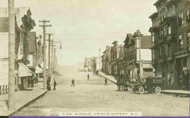
Photograph depicts the bow end of a ship getting swamped by a wave in rough water.
Photograph depicts the bow of a weather ship swamped with water after waves broke over the side of the ship.
Map depicts location of treasure hidden between Clearwater and Clemina, BC.
Postcard depicts "Canadian Pacific's all Stainless Stel Scenic Dome Streamliner-"The Canadian"-in the Canadian Rockies."
Postcard depicts "VIA Rail Canada Nos. 6456 and 6454 hauling Train No. 1, "The Canadian" between Spences Bridge and Drynoch, British Columbia, on Canadian Pacific's Thompson Subdivision, having been delayed by the need to detour, from its usual route, on Canadian National's Ashcroft Subdivision, seen here across the Thompson River. May 14, 1993."
Postcard depicts "Canadian Pacific's eastbound, "The Canadian," crosing the Kicking Horse River between Golden and Field B.C. in October 1976. Some of the... trains power through some of North America's most spectacular scenery. The morning has brought the season's first snowfall."
File consists of a 1936 thesis written by Arthur J. Johnson entitled "The Canadian Pacific Railway and British Columbia, 1871-1886" from the University of British Columbia.
Tourist map of Prince George depicts city area, including railway trackage.
Slightly elevated front-facing photograph of a steam engine and cargo coming into a station in Prince Rupert, BC. Coal and lumber yards are visible in the background. Annotation on recto reads: "The C.N.R. Prince Rupert. 79."
Group of men stand on pier by warehouse, looking out at the boat. Treed mountains visible in background.
Handwritten photo caption beside image reads: "Danube".
Image depicts the Duchess engine, which was built in 1878 and taken out of service in 1919. It was part of a matched set with the Duke and is now a tourist attraction in Carcross, Y.T.
File consists of notes and reproductions relating to a railway article written by Kent Sedgwick entitled "The East Line Section of the Grand Trunk Pacific Railway in Central British Columbia" (2010).
Postcard depicts "The Four Tracks."
Postcard depicts the Four Tunnels on the CPR line through the Rocky Mountains.
Postcard depicts "Twin Bridges in the Fraser Canyon. The CNR and CPR change sides at this point."
Postcard depicts 'The Gap," the entrance to the Rockies.
Postcard depicts the Golden-Field Highway as seen from high up on the mountain side from a tunnel on the CPR run in the Kicking Horse Canyon.
Postcard depicts the Canadian Pacific Railway line where the Great Divide between BC and Alberta.
Postcard depicts the Illecillewaet Valley, near Glacier, BCThe view shows the end of the descent over Rogers Pass, if travelling westerly. The scar in the foreground was believed to be the track between the 1st (Glacier Hotel) and 2nd (Loop Brook) loops.
Postcard depicts the Kicking Horse Canyon near Yoho National Park.
Postcard depicts "The Loop, as this great pear-shaped arc of trestle was known along with the spectacular station and hotel facilities at Glacier were replaced by the Connaught Tunnel in 1916."
Postcard depicts "The Loop," CPR Selkirks.
Postcard depicts "The Loop," CPR, Selkirk Mountain.
Postcard depicts "The Loop," Glacier, BC
Map depicts the province of British Columbia. Includes rail lines and historical notes about the province.
Photograph depicts the boat "John Antle" motoring on the water near a rocky, tree covered cliff. Handwritten annotation on verso states: "M.S. John Antle on her rounds entering Smuggler Cove". Stamped annotation on verso reads: “The National Film Board”
Handwritten annotation on verso reads: " '[Naskeena?' anchored off Metlakatla with Dr. [Mc-?] & Capt. Barry standing on its deck".
Tourist map of Prince George depicts city area, with annotations by Davies to emphasize locations of rail lines.
Stern wheeler “Port Simpson” tied to riverbank. Printed annotation on recto reads: “On the Skeena river, Hazelton, B.C.” Handwritten message on verso is addressed to “Mrs. Flossie Strong 6 Nah St. Watermill ME, U.S.A” 1 cent Canadian postage stamp has been canceled with a date of “Dec 24, 5:30 PM 1915 Buffalo N.Y.”
Photograph depicts the "Princess of Vancouver" loading at 7 p.m. in Vancouver.
Side perspective street view of the Royal Hotel in Prince Rupert BC. The "Ladies [sic] Entrance" sign is visible on the right side of the building. Several vehicles can be seen on the street. Printed annotation on recto reads: " 3rd Ave Prince Rupert Photo W.W.W."
Map depicts the route of BC Rail and its connecting rail lines.
Postcard depicts a spiral tunnel near Field B.C. Mount Stephen visible.
Postcard depicts 'The Spiral Tunnels."
Postcard depicts spiral tunnels near Yoho National Park, BC
Photograph depicts the split of the Great Northern Railway (GNR) (shown) and the Canadian National Railway (CN) tracks, immediately south of the Fraser crossing at New Westminster.
Stern wheelers “Operator” and “Conveyor” in dock. Printed annotation on recto reads: “S.S. “Operator” and “Conveyer” at Fort George, B.C. No. 107.”
Publication is entitled "The Terms of BC's Entry into Confederation as they Relate to Transportation" by John Christopher of the Research Branch, Library of Parliament.
Postcard depicts the town of Field and Mt. Stephen. Near Yoho National Park in the Canadian Rockies.
Image depicts half of a ship, which is named the Tutshi, in Carcross, Y.T.
Postcard depicts the Van Horne Range, looking west from Field, BC
Postcard depicts the west portal of the Connaught Tunnel, near Glacier, BCDavies noted the ventilation engine house above the entrance.
Photograph of a small vessel on the ocean with a dock and harbour buildings in the foreground. Tents and piles of lumber can be seen among the buildings. Annotation on recto reads: "The Wharf, Prince Rupert, BC. 1657."
Photo depicts a street perspective of Third Ave., in Prince George, BC, ca. 1950. Handwritten annotation in pen on verso of postcard reads: “You will undoubtedly notice that there are no tall buildings. I don’t think that there is one building in Prince George that is even five stories tall.”
Street view taken from the intersection of Third Avenue and Sixth Street in Prince George BC. A drugstore and several cafes can be seen on the left side of the street. Printed annotation on recto reads: "3rd Ave & 6th Street Prince Rupert BC."
Street view of Third Avenue in Prince Rupert. Printed annotation on recto reads: "Third Ave Prince Rupert B.C. Photo W.W.W."
Elevated view of Third Avenue in Prince Rupert. What appears to be a firetruck is travelling down the road. Printed annotation on recto reads: "3rd Ave W Prince Rupert BC."
Street view of Third Avenue in Prince Rupert, BC. Several cars are visible parked along the sides of the paved street. Printed annotation on recto reads: "Third Ave. W Prince Rupert- BC."
Street scene depicting people, boardwalks, horse & wagons, and delivery truck. Printed annotation on recto reads: “3rd Ave. Prince Rupert. B.C.”
Typed annotation in red ink on recto reads: “3rd Ave. Prince Rupert. B.C.” People, boardwalks, horse & wagons and store signs are visible. Rubble and unknown material lies on ground between boardwalks. Typed annotation in red ink on recto reads: “3rd Ave. Prince Rupert. B.C.”