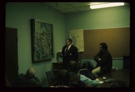
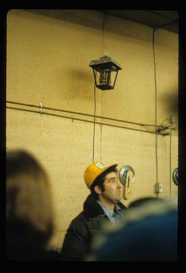
Image depicts an unidentified man in a yellow hat who appears to be speaking to large group of people. It is possibly an educational event.
Image depicts a man, possibly Kent Sedgwick, standing next to a monument which states: "In honour of the pioneers of the Ootsa Lake Valley, first settled in 1905." Located somewhere in either the Francois Lake Provincial Park or the Wistaria Provincial Park.
Image depicts a man, with what is possibly the Robson Glacier visible in the background.
Image depicts several buildings along the main street in Stewart, B.C. One of them has been boarded up.
Image depicts several buildings along the main street in Stewart, B.C.
Image depicts the main street of Stewart, B.C.
File consists of a note and reproduction relating to Mackenzie, BC.
File contains slides depicting places in and around Mackenzie Town.
Image depicts the Mackenzie Reservoir in Mackenzie, B.C.
The item is a photograph depicting a group of people on either side of the new Alexander Mackenzie monument for the unveiling in Fort George Park. Date handwritten on the reverse side of the photograph states, "July 31/85."
Image depicts numerous vehicles in the parking lot of a mall in Mackenzie, B.C.
Image depicts the Mackenzie Curling Rink.
Image depicts a small section of Mackenzie, with the Mackenzie Curling Rink visible on the right side of the image.
Image depicts numerous vehicles parked outside a building with a sign which reads "Mackenzie Centre;" it is possibly the mall in Mackenzie, B.C.
Image depicts an individual standing next to the world's largest tree crusher in Mackenzie, B.C.
Image depicts the world's largest tree crusher in Mackenzie, B.C.
Image depicts a truck parked on a beach in Mackenzie, B.C.
Image depicts a trailer park somewhere in Mackenzie, B.C.
Image depicts a trailer park in Mackenzie, B.C.
Image depicts a row of houses in Mackenzie, B.C.
Image depicts numerous individuals wearing hard hats in what appears to be a computer room somewhere in Mackenzie, B.C.
Image depicts the frozen Morfee Lake just to the East of Mackenzie, B.C. The slide is also labelled "sub-boreal," referencing that it is a sub-boreal spruce zone.
Image depicts numerous individuals examining a map as they are seated around a table. The location of the meeting is somewhere in Mackenzie, B.C.
Image depicts numerous individuals seated around a table and apparently having a meeting at an uncertain location in Mackenzie, B.C.
Image depicts numerous individuals inside a mall in Mackenzie, B.C.
Image depicts a row of houses in Mackenzie, B.C.
Image depicts several apartment buildings and the sign for a Gulf Gas Station in Mackenzie, B.C.
Image depicts numerous condominiums somewhere in Mackenzie, B.C.
File consists of notes and reproductions relating to the MacKay family in Strathnaver, British Columbia.
The photograph depicts machinery in the interior of the roundhouse in the CN Railyard in Prince George, B.C. Reproduction of photograph from 1984.
Image depicts a large, old piece of machinery, possibly some form of mining or prospecting equipment; it is located in Quesnelle Forks, B.C.
File consists of notes and reproductions relating to a heritage house at at 1111 Connaught Drive, Prince George, which was the residence of Dr. John McArthur. Dr. John McArthur was a general practitioner in Prince George, who was involved with community life, including coaching of the local PG Senior Hockey Team.
File consists of notes and reproductions relating to Lutheran churches in Prince George. The Connaught Hill Lutheran Church took over the original Knox Presbyterian Church in South Fort George, which later moved into the new Knox Presbyterian Church at Fifth and Brunswick Street. By 1958 there were two Lutheran Churches including Our Saviour's Lutheran Church at 3590 Dufferin, and the Zion Lutheran Church at 180 South Tabor Street in Prince George.
File consists of notes and reproductions relating to Luther Collins Gunn and L.C. Gunn Park. Luther Colins Gunn was a survey engineer who had done work for the Grand Trunk Pacific Railway and the Pacific Great Eastern Railway when he arrived in Prince George. The L.C. Gunn trail follows the same route used by Gunn when surveying the rail routes in the Prince George area. Includes: "Gunn Point" typescript document by Ted Williams for the Heritage Advisory Committee (1985); "A Proposal - The L.C. Gunn Viewpoint" typescript letter to Mr. Mac Norris, president of the B.C.R. Company from Ted Williams and the Heritage Advisory Committee (27 Jan. 1987); and "Item of business, proposed use of District Lot # 486" typescript letter from the Heritage Advisory Committee to Beverley Pitman, Planning Assistant (31 May 1979). Also includes photographs depicting the Moffat farm (2005).
The item is a 35 mm photograph negative depicting the remaining lumber beams after the fire at the Bank of Montreal in Prince George.
The item is a photograph depicting the remaining lumber beams after the fire at the Bank of Montreal in Prince George.
The item is a 35 mm photograph negative depicting the remaining lumber beams after the fire at the Bank of Montreal in Prince George.
The item is a photograph depicting the remaining lumber beams after the fire at the Bank of Montreal in Prince George.
Image depicts two unknown individuals canoeing on the lower part of Spectacle Lake.
Image depicts the lower end of the river channel leading to the Spectacle Lakes.
Image depicts a view of the lower Cayoosh Valley.
The item is a photograph slide reproduction depicting low water levels and the dried riverbed on the Fraser River.
The item is a photograph depicting low water levels and the dried riverbed on the Fraser River.
The item is a photograph depicting low water levels on the Fraser River and the Yellowhead Bridge. Annotation on accompanying note states, "C. Oct. 20 2006 low water."