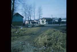
Photograph depicts a residential building at 1795 10th Avenue. Annotation on verso: "1795 - 10th Ave, SE corner of, Winnipeg".
Photograph depicts a residential building at 1798 5th Avenue. Annotation on verso: "1798 - 5th Ave".
Photograph depicts a residential building at 825 Vancouver Street. Annotation on verso: "Van Horlick c-7".
Photograph depicts a residential building on the corner of Vancouver Street and 10th Avenue. Annotation on verso: "Trick house, Vancouver/ 10th".
Photograph depicts a residential building at the corner of 6th Avenue and Winnipeg Street. Annotation on verso: "NE corner, 6th / Winnipeg".
Photograph depicts residential buildings at 1662 and 1674 9th Avenue, one with a green roof and one with a metal roof. Annotation on verso: "1674 - 9th Ave green roof), 1662 - 9th Ave (metal roof)."
Photograph depicts residential buildings along 4th Avenue east of Winnipeg Street. Annotation on verso: "series on s. side of, 4th east from Winnipeg, (railway houses)".
Image depicts a river, possibly the Nechako, in Prince George, B.C. Possibly taken from the Foothills Bridge.
Photograph depicts Rosel's restaurant at 1624 7th Avenue. Rosel's restaurant was owned and operated by Wilfred and Rosel Vogt from 1981 to 1997. The building was built in 1916 and was originally owned by Dr. Carl Ewart and later owned by Hubert King of Wilson, King and Company, the oldest law firm in Prince George, after 1946. The building is now a designated heritage building.
Image depicts the Royal Canadian Legion building on 7th Ave and the Inn of the North Coast Hotel in the background. Map coordinates 53°54'50.6"N 122°44'56.1"W
Image depicts several old, ruined cars and an unknown individual in Island Cache.
Image depicts the Salvation Army on Ospika Boulevard in Prince George, B.C. Map coordinates 53°55'02.6"N 122°47'41.6"W.
Image depicts the Salvation Army on Ospika Boulevard in Prince George, B.C. Map coordinates 53°55'02.6"N 122°47'41.6"W
Image depicts sand beds with a shovel present for size reference. The slide places it at the "BCR site," possibly in Prince George, B.C.
Image depicts a sawmill, possibly Lakeland Sawmill, in Prince George B.C.
Image depicts logs being stripped of their bark at a saw mill in Prince George, B.C.
Image depicts the interior of a saw mill somewhere in Prince George, B.C.
Image depicts logs being cut into planks in the interior of a saw mill somewhere in Prince George, B.C.
Image depicts wood planks in the interior of a saw mill somewhere in Prince George, B.C.
Image depicts a saw mill, possibly Lakeland Mills, with a beehive burner and numerous piles of logs in the foreground, in Prince George, B.C.
Image depicts numerous stripped logs and several unidentified individuals in hard hats at a saw mill somewhere in Prince George, B.C.
Image depicts a saw cutting a log in half at a saw mill in Prince George, B.C.
Image depicts numerous blocks of wood planks at a saw mill, possibly Lakeland Mills, somewhere in Prince George, B.C.
Image depicts machinery in a saw mill somewhere in Prince George, B.C.
Image depicts machinery stripping a log of its bark in a saw mill somewhere in Prince George, B.C.
File contains slides depicting schools in Prince George, B.C.
Image depicts the Seymour Subdivision in Prince George, B.C.
Photograph depicts the Shearer building in Prince George. Annotation on verso: "Shearer bldg".
Image depicts a number of sheds in Island Cache.
Image depicts the shore line and surrounding land of a lake or river at an airport, possibly in Prince George, B.C.
Image depicts layers of silt along the Chilako River near Blackwater Road, Prince George, B.C.
Image depicts two unidentified individuals examining a tractor meant to delimb trees. It is located in Prince George, B.C.
Image depicts a skier in a costume with a fake sword, somewhere on the Birchleg Ski route on Tabor Mountain in Prince George, B.C.
Image depicts a vehicle and a large group of skiers somewhere on Tabor Mountain in Prince George, B.C.
Image depicts numerous skiers and skis that are standing upright in in the snow on Tabor Mountain in Prince George, B.C.
Image depicts numerous skiers on the Birchleg Ski route on Tabor Mountain in Prince George, B.C.
Image depicts numerous skiers cross-country skiing on a trail through trees on the Birchleg Ski route on Tabor Mountain in Prince George, B.C.
Image depicts the slopes of Tabor Mountain in Prince George, B.C.
Image depicts a cemetery in the South Fort George suburb of Prince George, B.C.
Image depicts a house somewhere in the South Fort George subdivision of Prince George, B.C.
Image depicts a few houses, most likely near the airport in Prince George, B.C.
Image depicts a rural setting, most likely near the airport in Prince George, B.C.
Image depicts a Lakewood view of Spruceland in Prince George, B.C.
Image depicts a long line of people cross country skiing along the Birchleg route on Tabor Mountain in Prince George, B.C.
Image depicts a few storage sheds somewhere in Prince George, B.C.
Image depicts a small stream somewhere on Cottonwood Island.