Zone du titre et de la mention de responsabilité
Titre propre
Dénomination générale des documents
- Document graphique
Titre parallèle
Compléments du titre
Mentions de responsabilité du titre
Notes du titre
Niveau de description
Cote
Zone de l'édition
Mention d'édition
Mentions de responsabilité relatives à l'édition
Zone des précisions relatives à la catégorie de documents
Mention d'échelle (cartographique)
Mention de projection (cartographique)
Mention des coordonnées (cartographiques)
Mention d'échelle (architecturale)
Juridiction responsable et dénomination (philatélique)
Zone des dates de production
Date(s)
-
[1915?] (Production)
Zone de description matérielle
Description matérielle
1 photograph : b&w
Zone de la collection
Titre propre de la collection
Titres parallèles de la collection
Compléments du titre de la collection
Mention de responsabilité relative à la collection
Numérotation à l'intérieur de la collection
Note sur la collection
Zone de la description archivistique
Portée et contenu
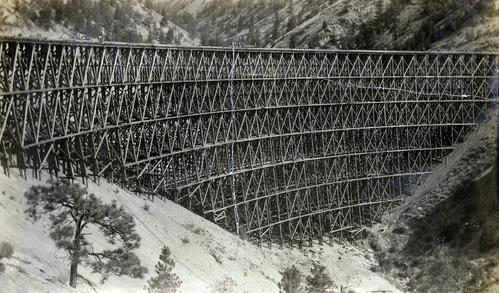
Photograph depicts the Pacific Great Eastern Railway trestle located near Sallus Creek in the area around Lillooet, Fountain, and Pavilion. A number of men are working along the trestle, possibly completing final construction work or performing repairs. "Canadian Railway and Marine World" reported that track had been laid to 14 miles North of Lillooet by July 30, 1915 (CR&MW , Sept 1915, p341, c2). 14 miles North of Lillooet is approximately 20 rail lengths beyond the North end of this trestle, leading to a "best estimate" of very late July 1915 or later as the earliest dates for this photograph.
The ca. 1921-1927 “PGE Bridge List” from the notebook of William H. Hewlett (1914-1968) references a Mile 13.7, 14 Mile Creek, frame trestle, 905 ft. long, 182 ft. high, 61 spans of 14.8 feet in the Lillooet Subdivision. A “PGE Track Profile” drawing shows this trestle was on a 1.55% grade and a 12 degree left hand curve. While the drawing had been revised at least twice (with an unknown date for the most recent revision), the pre-“Lillooet Diversion of 1931" mileage figures confirm that the 1915 “Mile 13.7" was in agreement with a more recent hand written note “Sallus Creek”. The trestle appears to have gone by the names "14 Mile" trestle, "13.7 Mile Trestle", and "Sallus Creek" trestle.
Zone des notes
Classement
Langue des documents
Écriture des documents
Localisation des originaux
Disponibilité d'autres formats
Item is digitized and available in high-resolution TIFF and JPEG formats. Digital access JPEG available here has been retouched for increased visibility.
Restrictions d'accès
No restrictions.
Délais d'utilisation, de reproduction et de publication
Personal or academic use of materials is welcomed under the standard fair use and educational use clauses of Canadian Copyright Law. Commercial use is, however, forbidden without the express permission of the copyright holder. For information on obtaining written permission from the copyright holder, please contact the Northern B.C. Archives and Special Collections.
Instruments de recherche
Générer l'instrument de recherche
Éléments associés
Accroissements
Note générale
Part of the Pacific Great Eastern Railway Region Photograph Collection
Identifiant(s) alternatif(s)
Numéro normalisé
Numéro normalisé
Mots-clés
Mots-clés - Sujets
Mots-clés - Lieux
Mots-clés - Noms
Mots-clés - Genre
Zone du contrôle
Sources
Information provided by Greg Kennelly, amateur PGE railway historian

