Map depicts terrain in the Aleza Lake Research Forest. Ecosystem classification and mapping by Oikos Ecological Services Ltd.
Map indicates locations of research trials and permanent plots in the Aleza Lake Research Forest. Map produced by Madrone Consultants.
Item is a British Columbia Forest Cover Map, serial number 093J010. Includes full format forest cover labels.
Item is a British Columbia Forest Cover Map, serial number 093I001. Includes full format forest cover labels.
Item is a British Columbia Forest Cover Map, serial number 093J010. Includes full format forest cover labels.
Mylar map depicts the area encompassed by the Aleza Lake Research Forest.
Series consists of photographs created or accumulated by the Aleza Lake Research Forest Society.
Photographs are panoramas taken from the Churchill BC Forest Service Lookout, located at latitude 54°04' and longitude 122°16'. The photographs were bound together and include a transparent grid that was intended to be used for locating forest fires.
File consists of slides depicting the Aleza Lake Research Forest and area taken by John Revel.
Slide depicts a man operating heavy equipment in a forest, likely at the Aleza Lake Experiment Station.
Slide depicts a heavily forested area with fallen logs, likely at the Aleza Lake Experiment Station.
Slide depicts a sawmill in operation, likely located in the Upper Fraser area, with a pile of burning wood products and a beehive burner.
Slide depicts a black bear eating garbage by wooden outbuildings, possibly at the Aleza Lake Experiment Station.
Slide depicts the original wooden BC Forest Service sign for the Aleza Lake Forest Experiment Station.
Slide depicts a detonation in an area of cleared ground in a forested area, likely the Aleza Lake Experiment Station. Work may have been undertaken for roadbuilding activities at the Experiment Station.
Slide depicts a cleared area in a forest, likely at the Aleza Lake Experiment Station.
Slide depicts a burning building at the Aleza Lake Experiment Station on the date it was shut down by the BC Forest Service.
Slide depicts a cleared area at the Aleza Lake Experiment Station with plant regeneration.
Slide depicts a view of what is possibly the Upper Fraser River.
Slide depicts the Ranger Station at the Aleza Lake Experiment Station.
Slide depicts cleared ground and felled trees in a forested area, likely at the Aleza Lake Experiment Station.
Slide depicts a bulldozer clearing ground, likely at the Aleza Lake Experiment Station.
File consists of slides depicting the Aleza Lake Research Forest and area taken by Michael Jull.
Photograph depicts Harry Coates, Ted Baker, and John Revel at Aleza Lake Research Forest re-opening ceremony on July 9, 1992.
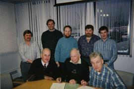
File consists of a photograph commemorating the signing of the first Aleza Lake Research Forest Management Plan. Front row, left to right: Ken Pendergast, BC Forest Service Prince George District Manager; Harry Coates, BCFS Forest Research Technician (1957-1993); John Revel, BCFS Silviculture Forester (1960-1993). Back row, left to right: Mike [?], BCFS Prince George Silviculture Manager; Henry Benskin, BCFS Research Branch; Michael Jull, BCFS Research Silviculturist, Prince George Region; Dan Lousier, BCFS Prince George Region Research Section Head; Brian Harding, Northwood Pulp & Timber Ltd. Woodlands Manager.
Aerial photograph depicts a view overlooking the Georges farm. Note on back stated that this photograph was presented in a frame to the Georges in 2008.
Contains significant materials covering a wide range of topics related to forestry research and forest management practices in Central British Columbia from the 1920s to the 1980s with the bulk of the materials dating from 1924 to 1963. Includes early surveys and descriptions of the Upper Fraser area, early maps and plans of the Research Forest, and historical meteorological registers from the area. Also includes unpublished scientific reports, communications, administrative and technical reports, timber sale records, and general forestry related reports and publications. Photographs include images of the Experimental Station dating from its inception and images of the Young Men's Forestry Training Program situated at Aleza Lake in 1936. Research records include experimental plot files that contain field notebooks dating from 1928 to 1958 which note locations of the experimental plots as well as sample plots from the surrounding areas of Hutton, Penny, and Foreman. The field notebooks also record growth and mortality data of white spruce balsam from 1928 to 1958 and soil types. The fonds also contains some records related to the re-emergence of the Aleza Lake Research Forest (ALRF) in the 1980s and 1990s.
Zonder titelMap commissioned from Ministry of Forests Prince George Region from Madrone Consultants shows Aleza Lake Research Forest Research Trials and Permanent Plots. Map is 2 of 6. Map shows permanent plot locations, historical timber sales areas, demonstration areas, and research plots.
Map commissioned from Ministry of Forests Prince George Region from Madrone Consultants shows Aleza Lake Research Forest Access and Access Management. Map is 3 of 6. Map shows the following road types: all weather 1-lane gravel road, dry weather road, and proposed road access. Also shows areas for parking/turnaround, toilets, and information signs.
Map commissioned from Ministry of Forests Prince George Region from Madrone Consultants shows an Aleza Lake Research Forest TRIM Base Map. Map is 4 of 6. Map shows the following: roads, old roads, buildings, rail line, transmission line, definite streams, intermittent streams, indefinite streams, marshes, swamps, lakes, wooded area boundaries, intermediate contour lines (20m intervals), and index contour lines (100m intervals).
Map commissioned from Ministry of Forests Prince George Region from Madrone Consultants shows Aleza Lake Research Forest ecosystems. Map is 5 of 6. Map shows many sub-types of the following ecosystem types: upland, lowland wet forest, wetlands, and the Bowron floodplain benches. Ecosystem classification and mapping by Oikos Ecological Services Ltd.
Map commissioned from Ministry of Forests Prince George Region from Madrone Consultants shows Aleza Lake Research Forest terrain themes. Map is 6 of 6. Map shows the following types of terrain units: typic, slope, percipitous, gullied, hummocky, rocky, alluvial, and organic. Ecosystem classification and mapping by Oikos Ecological Services Ltd.
Map commissioned from Ministry of Forests Prince George Region from Madrone Consultants shows Aleza Lake Research Forest Terrain Resource Inventory Mapping (TRIM). Depicts roads, area boundaries, swamps, streams, marshes, contour lines and index lines.
Map commissioned from Ministry of Forests Prince George Region from Madrone Consultants shows Aleza Lake Research Forest site series classification. Shows ecosystem types that encompass the SBSwk1 Subzone of the Aleza Lake Research Forest.
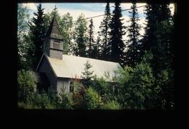
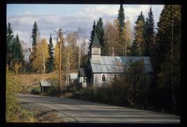
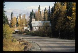
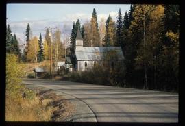
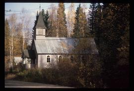
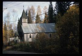
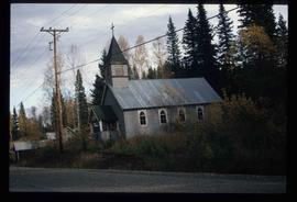
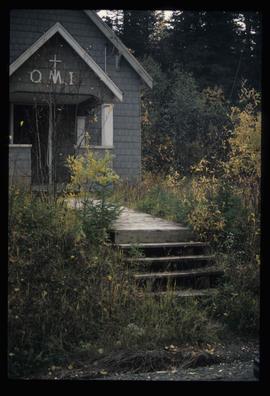
Image depicts the Oblates of Mary Immaculate Catholic Church in Aleza Lake, B.C. Map coordinates 54°07'08.2"N 122°02'00.0"W
File contains slides depicting places along the east line of the BC Railway.
Image depicts the Oblates of Mary Immaculate Catholic Church in Aleza Lake, B.C. Map coordinates 54°07'08.2"N 122°02'00.0"W
Image depicts the Oblates of Mary Immaculate Catholic Church in Aleza Lake, B.C. Map coordinates 54°07'08.2"N 122°02'00.0"W
Image depicts the Oblates of Mary Immaculate Catholic Church in Aleza Lake, B.C. Map coordinates 54°07'08.2"N 122°02'00.0"W
Image depicts the Oblates of Mary Immaculate Catholic Church in Aleza Lake, B.C. Map coordinates 54°07'08.2"N 122°02'00.0"W
Image depicts the Oblates of Mary Immaculate Catholic Church in Aleza Lake, B.C. Map coordinates 54°07'08.2"N 122°02'00.0"W
Image depicts the Oblates of Mary Immaculate Catholic Church in Aleza Lake, B.C. Map coordinates 54°07'08.2"N 122°02'00.0"W
Image depicts the Oblates of Mary Immaculate Catholic Church in Aleza Lake, B.C. Map coordinates 54°07'08.2"N 122°02'00.0"W
Image depicts the Oblates of Mary Immaculate Catholic Church in Aleza Lake, B.C. Map coordinates 54°07'08.2"N 122°02'00.0"W
Subseries consists of material collected by Kent Sedgwick for research regarding the communities along the East Line of the Grand Trunk Pacific Railway in Central British Columbia, particularly between Prince George and McBride. These communities and locations include, among others, Shelley, Willow River, Sinclair Mills, Longworth, Dunster, Tete Jaune, Valemount, Mount Robson, and the Yellowhead Pass. Research on these communities was conducted during Kent Sedgwick's involvement in the UNBC-led Upper Fraser Historical Geography Project. The files primarily consist of research notes, audio and transcripts of oral interviews, and photographs of the East Line communities.
Fonds consists of records Harry Coates created or received and retained during his career as a BC Forest Service Research Technician and into his retirement as a Sustainable Forest Management activist. Fonds includes materials from his work at the Aleza Lake Research Forest.
Zonder titelFile consists of the Aleza Lake Research Forest Management and Working Plan #2 Draft #3 for the period of April 1, 1997 to March 31, 2002, pertaining to special use permit #19070, submitted by the Aleza Lake Steering Committee and prepared by Madrone Consultants Ltd. May 9, 1997. File includes related correspondence and a briefing note. File includes a map insert of Aleza Lake Research Forest land management units and boundaries also by Madrone Consultants Ltd. May, 9, 1997, Scale 1:20,000.
File consists of a photocopy of the Aleza Lake Research Forest Management and Working Plan #1 For the Period of April 1, 1992 to March 31, 2002 Pertaining to Special Use Permit # 19070 (November 1, 1992). File also includes Aleza Lake Research Forest: List of Reports, Articles etc.; a Request for Proposals for the ALRF Ten-Year Management Plan Update and Research Extension Strategy Development; a Draft of the Joint Protocol for Co-ordination Research and Operational Planning Activities at the Aleza Lake Research Forest; Proposed Future Management Structure for the Research Forest; Amendment for Special Use Permit # 19070; and Seventy Years of Northern Forestry: The Aleza Lake Research Forest.
File consists of documentation on E.P. 670.01.03.01 "Aleza Lake Half Sib Progeny Trial".
File consists of documentation on a computer disk for the Aleza Lake Half-Sib Progeny Trial.


