Series consists of maps, plans, and drawings collected by faculty in the UNBC School of Planning and Sustainability. The majority of these maps reflect the planning history of the City of Prince George and include large format, hand-drawn plans created by the City Planning Department from the 1970s and 1980s. Maps from City of Prince George Official Community Plans are also included.
File consists of records created and accumulated by Gary Runka over the course of his consultancy work for Transport Canada for the "Drainage and Integrated Land Use Investigation - Boundary Bay Airport" project in Vancouver. This file was numbered as G.G. Runka Land Sense Ltd. client file #131; that client number may be seen referenced elsewhere in the G. Gary Runka fonds. The Land Sense Ltd. client files generally include records such as correspondence, contracts, invoices, project reports, publications, ephemera, memoranda, maps or map excerpts, legal documents, meeting materials, clippings, and handwritten notes. File also includes an accompanying oversize aerial photograph.
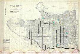
This municipal map of the City of Vancouver from 1987 shows street names and street widening information.
Drawing depicts visual notes taken at the 2020 Public Health Summer Institute with the theme "Think Globally, Act Locally: Public Health and the Anthropocene". Themes related to the COVID-19 pandemic are depicted.

