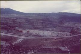
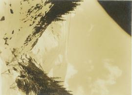
Showing 3619 results

Archival description
2000.1.1.2.03.04 · Item · 4 July 1964
Part of Cassiar Asbestos Corporation Ltd. fonds

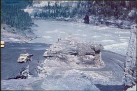
Handwritten annotation on recto of photograph: "FORMING FOOTING RETAINING WALL JULY 4/64." Photograph depicts construction workers
standing in forms for cement laid against mountain wall on high elevation of construction site. A retaining structure made with wood planks and rebar separates mountainside dirt from cement forms. A front end loader can be seen in midground, near unidentified building. Mountain range in background.

Dump Truck at Tailings Pile
2000.1.1.3.18.001 · Item · 1953
Part of Cassiar Asbestos Corporation Ltd. fonds

Photograph depicts red truck dumping waste at what is believed to be the tailings pile at the Cassiar plant. Small building and unidentified individual in bottom left foreground, valley and mountains in background. Photo caption next to printed copy of image in 1953 Annual Report: "Stockpile of 80,000 tons of Ore at Mill."

2000.1.1.3.18.003 · Item · September 1954
Part of Cassiar Asbestos Corporation Ltd. fonds

Photograph depicts large dry rock storage building in foreground on left, mill in background, dryer building in right midground. Miscellaneous supplies in far right foreground, mountains visible in background. Handwritten annotation on verso of photograph: "Sept 1954". This photograph was originally stored inside duotang labeled "CASSIAR ASBESTOS CORPORATION LIMITED PHOTOGRAPHS 1954"; photo caption beneath this image: "40,000 Ton Dry Storage Building / Mill / Dryer Building".

1961 - Mine Buildings
2000.1.1.3.19.003 · Item · 1961
Part of Cassiar Asbestos Corporation Ltd. fonds

Photograph depicts buildings at various locations in mine: crushing plant (centre?) and what is believed to be the original tramline loading station on left. Mine road featured in center, blasthole drill visible near dump truck in midground. Mine valley in background. Photo believed to have been taken from mine's South Peak. Handwritten annotation on verso of photograph: "1961".

2000.1.1.3.19.007 · Item · 1961
Part of Cassiar Asbestos Corporation Ltd. fonds

Photograph depicts an Atlas Copco Drillmaster (blasthole drill) near the mine road, mountainside in background. This is a precision hammer drill which had its own power source. It is believed that this photo was taken on the North ridge, near the cirque dump. Handwritten annotation on verso of photograph: "1961".

1961 - Explosive Preparation
2000.1.1.3.19.008 · Item · 1961
Part of Cassiar Asbestos Corporation Ltd. fonds

Photograph depicts a man wearing a hard hat preparing explosive material, mountains in background. Dog stands near edge in midground, large bags of Ammonium Nitrate in right foreground. Handwritten annotation on verso of photograph: "1961".

1961 - Power House
2000.1.1.3.19.017 · Item · 1961
Part of Cassiar Asbestos Corporation Ltd. fonds

Photograph depicts a large shelter over building believed to be power house. Electricity lines cross midground and run to power house. A man can be seen crossing the foreground by steel frame supplies, and a second building is partially visible on right. Mountains stand in background and a crane can be seen operating in front of power house. Handwritten annotation on verso of photograph: "1961".

1965 - Bar & Snackbar
2000.1.1.3.19.052 · Item · 1965
Part of Cassiar Asbestos Corporation Ltd. fonds

Photograph depicts building containing Cassiar's bar and snackbar, visible across ball field. This building originally housed school classrooms, movie theater, barber shop, and rec centre with three pool tables. Private liquor store originally located in far right of building. Liquor store was known to be the only legal bootleg liquor business in the province at the time, before it was transferred to Cassiar's government liquor store and replaced with a Sear's office. Catholic church and other buildings are visible behind trees in right midground. Road and field in foreground, valley and mountains in background. Community Centre located behind photographer, out of frame, curling rink on photographer's right.

2000.1.1.3.19.053 · Item · 1965
Part of Cassiar Asbestos Corporation Ltd. fonds

Photograph depicts men's ball game in foreground, spectators and cars visible behind backstop net. Bar and snackbar building in right midground, trees and mountain base in background. See item 2000.1.1.3.19.52 for information regarding bar and snackbar building.

1971 - Tramline on Plantsite
2000.1.1.3.19.083 · Item · 15 June 1971
Part of Cassiar Asbestos Corporation Ltd. fonds

Photograph depicts tramline buckets and tower on plantsite. Vehicles, building materials, and unidentified buildings also visible on plantsite (including what appears to be a water tower). Mountains and valley in background. Handwritten annotation on verso of photograph: "Cassiar June 15 71".

1971 - Director's Lodge
2000.1.1.3.19.088 · Item · 15 June 1971
Part of Cassiar Asbestos Corporation Ltd. fonds

Photograph depicts two unidentified men on front deck of building behind trees. Road and car in foreground, mountains visible in background. Handwritten annotation on verso of photograph: "Directors Lodge Cassiar June 15 71". Building also known as "House 130".

1971 - Unknown Residence
2000.1.1.3.19.090 · Item · 15 June 1971
Part of Cassiar Asbestos Corporation Ltd. fonds

Photograph depicts brown and white building similar to the "Director's Lodge" at Cassiar, B.C. (see items 2000.1.1.3.19.88 and 2000.1.1.3.19.89). Station wagon parked in driveway behind short fence in foreground. Trees in foreground, forest and mountains visible in background. Handwritten annotation on verso of photograph: "Cassiar June 15 71".

2000.1.1.3.19.101 · Item · [ca. 1975]
Part of Cassiar Asbestos Corporation Ltd. fonds

Photograph depicts the West Peak of the Cassiar mine on McDame Mountain. Pit area visible between West Peak and road in foreground. Mine valley and north mountain range in background. Photo speculated to have been taken from a point on or near the South or North Peak.

2000.1.1.3.19.195 · Item · [ca. 1980]
Part of Cassiar Asbestos Corporation Ltd. fonds

Photograph depicts ore cars on cables running between tramline towers on left. Road in right foreground, building and McDame mountain in background. Tramline ran through mine valley, between loading station in mine and dump station at mill on plantsite.

2000.1.1.3.24.02 · Item · Septmeber 1954
Part of Cassiar Asbestos Corporation Ltd. fonds

Photograph depicts wood houses behind stand of trees in Cassiar valley. Truck, power poles, and road in foreground, mountains in background. Typed caption below photo in original duotang album: "Two Bedroom Pan-Abode Houses - Cassiar Townsite". Handwritten annotation on verso: "Sept 1954".

2000.1.1.3.24.03 · Item · [ca. 1955]
Part of Cassiar Asbestos Corporation Ltd. fonds

Photograph depicts snow-plowed road lined with trees, valley and mountain in background. Believed to have been taken from vehicle. Handwritten annotation on recto of photograph: "Approach to Quartz Rock Creek".

2000.13.1.63 · Item · [between 1962 and 1967].
Part of Ray Williston fonds

Item is a photograph of the diversion tunnel as engineers plan to blast the plug to allow the Peace River to be diverted for construction of the W.A.C. Bennett Dam.

2008.3.1.22.14 · Item · [ca. 1995]
Part of Bridget Moran fonds

Woman stands in front of sign that reads "ALASKA / STEWART 237 km / HYDER AK. 240 km / BEAR GLAC. 201 km". Second sign in background indicates restaurant, convenience store, and service centre. Car, road, and highway can be seen in midground; mountains in background. (This woman is also featured in item 2008.3.1.22.13).

River and Mountains
2008.3.1.22.32 · Item · [ca. 1995]
Part of Bridget Moran fonds

Photograph depicts wide river with forest shores on either side. Power lines in foreground, mountain in background.

2008.2.1.09 · Item · 1 December 1923
Part of Northern BC Cartographic Collection

Colour-coded topographic map depicting lands surveyed as alienated, reserved, or statutory timber land. Depicts land district boundaries, land recording divisions, HBC posts, triangulation stations, telephone lines, communities, bodies of water, and transport routes. Defines resource type areas (“Land Form,” “Soil,” “Forest Cover,” “Grazing,” “Geological & Mineralogical,” “Fur-Bearing Animals & Game”). Includes explanatory “Natural Resources Reference.”

Central British Columbia
2008.2.1.21 · Item · 1 May 1940
Part of Northern BC Cartographic Collection

Topographic map depicts communities, bodies of water, transport routes, parks, game reserves, posts, ports, radio stations, power sites (figures in horse power), steamship routes (distance in nautical miles), and precipitation. Mineral resources summarized locally in red ink.