2009.5.1.60
·
Item
·
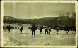
20 February 1911
Part of Taylor-Baxter Family Photograph Collection
Handwritten annotation on verso of photograph: "HOCKEY - HAZELTON. VS G.T.P.R [Grand Truck Pacific Railway] FEB. 20/11" Twelve players can be seen skating on ice, surrounded by large crowd of people standing on either side of the game. Referees dressed in suits stand around players, and a dog can also be seen in crowd. Snow pile in foreground; river banks, forest, and mountains in background.