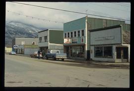
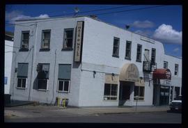
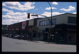
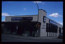
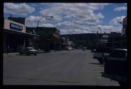
Showing 112 results

Archival description
2012.13.1.85.64 · Item · [2004?]
Part of J. Kent Sedgwick fonds

Image depicts an abandoned building on the corner of a street in McBride, B.C. The faded letters on the side read: "McBride Trading Co. Mens Wear, Drugs, Equipment."

Businesses
2012.13.1.7.250 · Item · [2003?]
Part of J. Kent Sedgwick fonds

Image depicts a street of businesses, possibly 3rd Avenue, in Prince George, B.C.

3rd Avenue
2012.13.1.7.222 · Item · May 2001
Part of J. Kent Sedgwick fonds

Image depicts a view of 3rd Avenue with the Columbus Hotel prior to the fire that destroyed it in 2008.

Third Avenue
2012.13.1.3.161 · Item · May 2001
Part of J. Kent Sedgwick fonds

Image depicts 3rd Ave in Prince George, B.C. Map coordinates 53°55'01.9"N 122°44'48.7"W

Street in Giscome - Before
2012.13.1.87.093 · Item · [between 1980 and 2000]
Part of J. Kent Sedgwick fonds

Image depicts a street in Giscome B.C. The Giscome Store is located on the left side of the image with the church in the background. Map coordinates 54°04'18.5"N 122°21'57.7"W

Atlin - the Garrett Store
2012.13.1.98.37 · Item · 1999
Part of J. Kent Sedgwick fonds

Image depicts the Garrett Store in Atlin, B.C. A plaque on it reads: "John Garrett, a prominent English cricket player, came to Atlin in 1910 to mine gold. In 1917 he opened this grocery and dry goods store where he also sold his wife's fresh baked bread and sweets."

2012.13.1.87.067 · Item · [between 1975 and 1995]
Part of J. Kent Sedgwick fonds

Image depicts a row of buildings in Upper Fraser, B.C. with the store (titled "Paradise") with a Pepsi sign. Map coordinates 54°07'09.1"N 121°56'47.0"W

2012.13.1.87.104 · Item · [between 1975 and 1995]
Part of J. Kent Sedgwick fonds

Image depicts a snowy street in Willow River, B.C. There are several buildings, one is an Esso station and another is labelled as "Red & White Food Store."

2012.13.1.87.148 · Item · [between 1975 and 1995]
Part of J. Kent Sedgwick fonds

Image depicts an advertisement for an "Uncle Ben's Beer Malt Liquor" in the Willow River General Store. Map coordinates 54°04'23.7"N 122°28'26.9"W

Upper Fraser General Store
2012.13.1.87.043 · Item · [between 1975 and 1995]
Part of J. Kent Sedgwick fonds

Image depicts the Upper Fraser General Store in Upper Fraser, B.C. Two other signs indicate that it is also a post office and a place that offers propane refills. Map coordinates 54°07'10.8"N 121°56'51.7"W

2012.13.1.3.110 · Item · 12 Oct. 1989
Part of J. Kent Sedgwick fonds

Image depicts George St in downtown Prince George with City Hall in the background. Also visible are the Prince George Hotel, Ming's Inn Chinese Restaurant, Fraser Stationers Ltd., Weiner King food cart, and a movie theatre. Map coordinates 53°54'55.0"N 122°44'36.1"W

Pine Centre Mall
2012.13.1.3.111 · Item · 12 Oct. 1989
Part of J. Kent Sedgwick fonds

Image depicts Pine Centre Mall in Prince George, B. C. Map coordinates 53°53'53.2"N 122°46'36.4"W

Central Street West
2012.13.1.3.115 · Item · 12 Oct. 1989
Part of J. Kent Sedgwick fonds

Image depicts Central Street West, parallel to Highway 97 in Prince George, B.C. looking north. Shown: Prince George Motors and other car dealerships, Burger King, Grama's Inn, and the Spruceland Shopping Mall sign. Map coordinates 53°54'42.1"N 122°46'53.1"W

2012.13.1.3.108 · Item · 12 Oct. 1989
Part of J. Kent Sedgwick fonds

Image depicts 4th Ave at Quebec St, showing the following businesses: The Yarn Barn, Golden Chalice Jewellers, Dandy Lines, Ultrasport, and Saveco. Map coordinates 53°54'58.6"N 122°44'47.5"W

Likely
2012.13.1.69.03 · Item · July 1981
Part of J. Kent Sedgwick fonds

Image depicts numerous vehicles and individuals outside a hotel in Likely, B.C.