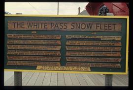
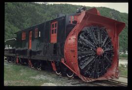
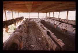
Image depicts the original steam engine for the White Pass Train, located in Skagway, Alaska.
Image depicts a sign, labelled "The White Pass Snow Fleet," which details the history of the fleet; it is located in Skagway, Alaska.
Image depicts the restored White Pass Snow Plow No.1 in Skagway, Alaska.
File contains slides depicting quotations and sketched images.
File contains slides depicting items and photographs in a museum.
File contains slides depicting photographs of the art works of the Group of Seven.
Image depicts the picnic site of the Cottonwood House Historic Site, located on the Barkerville Highway, east of Quesnel, B.C.
Image depicts the Cottonwood House Historic Site along Barkerville Highway, east of Quesnel, B.C. A sign posted by the fence reads: "For over half a century the Boyd family operated this haven for man and beast. Here weary travellers found lodging, food, and drink. Here fresh horses were hitched to stage-coaches and miners bought supplies. This historic road-house, built in 1864, stood as an oasis of civilization on the frontier of a rich new land."
File contains slides depicting the Summerfest in Prince George, B.C. in 1994.
Image depicts a marching band with numerous other unidentified individuals. One man is carrying a Canadian flag with the depiction of men in a boat and the words "Canada Sea-to-Sea" on it.
Image depicts a marching band with numerous other unidentified individuals. One man is carrying a Canadian flag with the depiction of men in a boat and the words "Canada Sea-to-Sea" on it, and there is a mascot beside him that appears to be a chipmunk in an RCMP uniform.
Image depicts a marching band with numerous other unidentified individuals. One man is carrying a Canadian flag with the depiction of men in a boat and the words "Canada Sea-to-Sea" on it.
Image depicts a woman, wearing clothes reminiscent of traditional First Nations, who appears to be dancing in the street outside of a Native Friendship Centre in Prince George, B.C. A large crowd is looking on.
File contains slides depicting the UBC Museum of Anthropology.
Image depicts a snow sculpture of a bear, possibly during the Winter City Conference, in Prince George, B.C. Taken at the Prince George Civic Center. Map coordinates 53°54'45.6"N 122°44'59.6"W
Image depicts two snow sculptures near a wooden bridge on an ice rink, possibly during the Winter City Conference, in Prince George, B.C. Taken at the Prince George Civic Center. Map coordinates 53°54'45.6"N 122°44'59.6"W
Image depicts a snow sculpted fire place and couch on a skating rink, possibly during the Winter City Conference, in Prince George, B.C. Taken at the Prince George Civic Center. Map coordinates 53°54'45.6"N 122°44'59.6"W
Image depicts a snow sculpture of the Mr. P.G. lounging on a couch, possibly during the Winter City Conference, in Prince George, B.C. Taken at the Prince George Civic Center. Map coordinates 53°54'45.6"N 122°44'59.6"W
Image depicts a snow sculpture of a man with a shovel, possibly during the Winter City Conference, in Prince George, B.C. Taken at the Prince George Civic Center. Map coordinates 53°54'45.6"N 122°44'59.6"W
Image depicts Studio 2880 Arts Complex in Prince George, B.C. Map coordinates 53°54'36.9"N 122°46'30.3"W
Image depicts the Wells Museum in Wells, B.C.
Image depicts the Two Rivers Art Gallery in Prince George, B.C.
Image depicts the Prince George Public Library.
Image depicts the Prince George Public Library from 7th Ave.
Image depicts the historical village of 'Ksan near Hazelton, B.C.
Image depicts a totem pole in the historical village of 'Ksan near Hazelton, B.C.
Image depicts a group of people in the historical village of 'Ksan near Hazelton, B.C.
Image depicts two totem poles in Skeena Crossing, B.C.
Image depicts numerous totem poles in Kispiox, B.C.
Image depicts a large gathering of people in the interior of a First Nations' longhouse located in the historical village of 'Ksan in Hazelton, B.C.
Image depicts an old, partially burnt totem pole in Kispiox, B.C.
Image depicts the 'Ksan historical village in Hazelton, B.C.
Image depicts the public library in Hazelton, B.C.
Image depicts numerous totem poles in Kispiox, B.C.
Image depicts a totem pole beside the grave marker of the Chief Lu-dal-da-zuatz, in Kispiox, B.C.
Image depicts the entrance to the historical village of 'Ksan in Hazelton, B.C.
Image depicts the historical village of 'Ksan in Hazelton, B.C.
Image depicts the Battle Hill National Historic Site in Kitwanga, B.C.. The sign located there says: "The small knoll in the valley was a native fortress. Legends maintain that it was man-made: built to repel marauding coastal tribes. The hill was the scene of local tribal battles, and at one time was crowned with the defenders' buildings. Known as Dhawdezp, the unique mound is a prominent feature in the legends and history of the Indian people."
Image depicts a street, possibly in Kamloops, which has been closed for a Sunday morning Farmer's Market.
Image depicts a representation of the crucified Christ in the St. Joseph's Roman Catholic Church in Kamloops, B.C.
Image depicts a row of totem poles in Kitwanga, B.C.
Image depicts a totem pole in Kitwanga, B.C.
Image depicts a row of totem poles in Kitwancool, B.C.
Image depicts several old totem poles on their sides in Kitwancool, B.c.