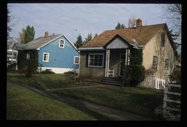
Photograph depicts a residential building at 1616 8th Avenue, on the corner of Vancouver Street. Annotation on verso: "1616 -8th Ave, NW corner of Vancouver".
Photograph depicts a residential building at the corner of 6th Avenue and Winnipeg Street. Annotation on verso: "NE corner, 6th / Winnipeg".
Photograph depicts a residential building at 1795 10th Avenue. Annotation on verso: "1795 - 10th Ave, SE corner of, Winnipeg".
Photograph depicts a residential building on the corner of Vancouver Street and 10th Avenue. Annotation on verso: "Trick house, Vancouver/ 10th".
Photograph depicts residential buildings along 4th Avenue east of Winnipeg Street. Annotation on verso: "series on s. side of, 4th east from Winnipeg, (railway houses)".
Photograph depicts a residential building at 1625 4th Avenue. Annotation on verso: "Loedel proposal, 1625 - 4th, (see above)".
Photograph depicts Canada Trust/ Realtor at 1633 4th Avenue.
Photograph depicts a residential building at 1651 5th Avenue. Annotation on verso: "1651 - 5th Ave".
Photograph depicts a residential building at 1661 10th Avenue. Annotation on verso: "1661 - 10th Ave".
Photograph depicts a residential building at 1770 5th Avenue. Annotation on verso: "1770 - 5th Ave".
Photograph depicts a residential building at 1612 12th Avenue, the building was used as "Prince Realty". Annotation on verso: "1612 - 12th Ave., NW corner of Vancouver."
Photograph depicts residential buildings at 1662 and 1674 9th Avenue, one with a green roof and one with a metal roof. Annotation on verso: "1674 - 9th Ave green roof), 1662 - 9th Ave (metal roof)."
Photograph depicts a residential building at 1617 8th Avenue. Annotation on verso: "1617 - 8th Ave".
Photograph depicts a residential building at 1648 8th Avenue. Annotation on verso: "1648 - 8th, next to Rosel's".
Photograph depicts a residential building at 1643 10th Avenue. Annotation on verso: "1643 - 10th Ave".
Photograph depicts a residential building at 825 Vancouver Street. Annotation on verso: "Van Horlick c-7".
Photograph depicts Rosel's restaurant at 1624 7th Avenue. Rosel's restaurant was owned and operated by Wilfred and Rosel Vogt from 1981 to 1997. The building was built in 1916 and was originally owned by Dr. Carl Ewart and later owned by Hubert King of Wilson, King and Company, the oldest law firm in Prince George, after 1946. The building is now a designated heritage building.
Photograph depicts a residential building at 1722 7th Avenue. Annotation on verso: "1722 - 8th Ave".
Photograph depicts a residential building at 1601 6th Avenue, the corner of 6th Avenue and Vancouver Street. Annotation on verso: "CUTE c-7, union, Vancouver/ 6th".
Photograph depicts a residential building at 1798 5th Avenue. Annotation on verso: "1798 - 5th Ave".
Photograph depicts Buchanan Benson Real Estate and Insurance at 1276 4th Avenue.
Photograph depicts Northern Hardware at 1386 3rd Avenue.
Photograph depicts "Gifts to Remember," a gift shop on 3rd Avenue, The Bay in the background.
Photograph depicts a Rental and repair shop on 3rd Avenue.
Photograph depicts a parking lot and alleyway behind the Europe Hotel on 3rd Avenue.
Photograph depicts the Hong Kong Inn and restaurant at 1210 3rd Avenue. Annotation on verso: "Dredaute Bldg c. 1948".
Photograph depicts the old post office and federal government building at 1299 3rd Avenue prior to the coat of arms removal. Annotation on verso: "fed. govt bldg, (post office), c. 1990, before, coat of arms, removal".
Photograph depicts the Europe Hotel on 3rd Avenue.
Photograph depicts various businesses along 3rd Avenue. The businesses include the Europe Hotel and The Bay in the background. Annotation on verso: "left Europe Hotel, right shearer bldg".
Photograph depicts the Shearer building in Prince George. Annotation on verso: "Shearer bldg".
Photograph depicts the Europe Hotel on the South side of 3rd Avenue. Annotation on verso: "Europe Hotel".
Image depicts 1690 Dogwood Street, on the corner of 17th Ave and Dogwood St. in Prince George, B.C. Also depicts a portion of 1670 Dogwood Street at left.
Image depicts 1650 Dogwood Street and 1670 Dogwood Street in the Millar Addition neighbourhood in Prince George, B.C.
Image depicts 1465 Elm Street, 1445 Elm Street, and 1425 Elm Street in the Millar Addition neighbourhood of Prince George, B.C.
Image depicts some of the 1445 Elm Street and 1425 Elm Street houses in the Millar Addition neighbourhood of Prince George, B.C.
Image depicts houses on Dogwood Street in the Millar Addition neighbourhood of Prince George, B.C. On the left is 1610 Dogwood Street and 1630 Dogwood Street is the middle house; 1650 Dogwood Street is the blue house on the right.
Photograph depicts KLM Engineering Ltd. at 1924 3rd Avenue. Annotation on verso: "KLM c-7, Native Head Start program?".
Image depicts the Fort George Park. Map coordinates 53°54'30.2"N 122°43'57.4"W
Image depicts the Four Seasons Leisure Pool, and the Centennial Fountain in Prince George, B.C. Map coordinates 53°54'48.5"N 122°44'49.2"W
Image depicts the Central Business District of Prince George looking north from Connaught Hill. Map coordinates 53°54'41.4"N 122°44'58.5"W
Image depicts Brunswick Street at 3rd Ave in -35 degree weather. Map coordinates 53°55'03.0"N 122°44'51.7"W
Image depicts 3rd Ave at Brunswick Street in -35 degree weather. Map coordinates 53°55'03.0"N 122°44'51.7"W
Image depicts a view of Prince George from Cranbrook Hill looking southeast. Map coordinates 53°54'51.5"N 122°49'05.2"W
Image depicts a view of Prince George from Cranbrook Hill looking east with pulpmill and downtown in background.
Image depicts a view of Prince George from Cranbrook Hill looking east.
Image depicts a view of Prince George from Cranbrook Hill looking southeast. Map coordinates 53°54'51.5"N 122°49'05.2"W
Image depicts a view of Prince George from Cranbrook Hill looking east. Map coordinates 53°54'51.5"N 122°49'05.2"W
Image depicts a view of Prince George from Cranbrook Hill looking southeast. Map coordinates 53°54'51.5"N 122°49'05.2"W
Image depicts a view of Prince George from Cranbrook Hill looking east. Map coordinates 53°54'51.5"N 122°49'05.2"W
Image depicts a view of Prince George from City Hall looking north. Map coordinates 53°54'46.3"N 122°44'41.9"W