Affichage de 46 résultats

Archival description
42 résultats avec objets numériques Afficher les résultats avec des objets numériques
Agriculture
2012.13.2.07 · Sous-série organique · 1978-2008
Fait partie de J. Kent Sedgwick fonds

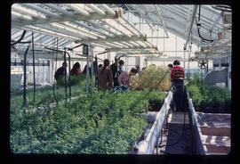
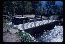
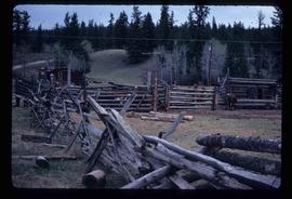
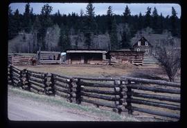
Subseries consists of material collected and created by Kent Sedgwick for research relating to agriculture in Prince George and the surrounding areas including Pineview, Mud River, and Blackburn. Includes material regarding the Prince George experimental farm, historical agriculture, dairying, and ranching.

Prince George Experimental Farm
2012.13.2.07.01 · Dossier · 1994-2004
Fait partie de J. Kent Sedgwick fonds

File consists of clippings, notes, reproductions, and letters relating to the Prince George Experimental Farm. Includes "District 'C' Farmer's Institute" letter correspondence between the director of development services and Marlene Schwartz (19 July 1999) and "RE: Century Farms Project" letter from Kent Sedgwick to the Ministry of Agriculture, Fisheries & Food (13 Sept. 1994). Also includes photographs depicting the experimental farm in Prince George, including the house on the property, a barn with a rainbow painted on the front, and the barn at multiple angles (Aug. 2001).

"Land Settlement: A Report"
2012.13.2.02.64 · Dossier · 1941
Fait partie de J. Kent Sedgwick fonds

File consists of a bound typescript book titled "Land Settlement (A report by a C.S.T.A Committee)" produced by the Canadian Society of Technical Agriculturists in 1941.

Giscome Dairy Farm
2012.13.1.89.080 · Pièce · [1980?]
Fait partie de J. Kent Sedgwick fonds

Image depicts the dairy farm in Giscome, B.C. Map coordinates 54°03'53.3"N 122°21'22.6"W

Giscome Dairy Farm
2012.13.1.87.152 · Pièce · [between 1975 and 1995]
Fait partie de J. Kent Sedgwick fonds

Image depicts the dairy farm in Giscome, B.C. Map coordinates 54°03'53.3"N 122°21'22.6"W

Giscome Dairy Farm
2012.13.1.87.141 · Pièce · [between 1975 and 1995]
Fait partie de J. Kent Sedgwick fonds

Image depicts the dairy farm in Giscome, B.C. Map coordinates 54°03'53.3"N 122°21'22.6"W

Farm
2012.13.1.54.65 · Pièce · July 1980
Fait partie de J. Kent Sedgwick fonds

Image depicts a farm at an uncertain location.

Farm
2012.13.1.54.66 · Pièce · 1981
Fait partie de J. Kent Sedgwick fonds

Image depicts a farm at an uncertain location.

Farm
2012.13.1.20.23 · Pièce · [2002 or 2003]
Fait partie de J. Kent Sedgwick fonds

Image depicts a farm likely in Woodpecker, B.C.

Farm
2012.13.1.20.24 · Pièce · [2002 or 2003]
Fait partie de J. Kent Sedgwick fonds

Image depicts a farm likely in Woodpecker, B.C.

Farm
2012.13.1.20.09 · Pièce · 1980
Fait partie de J. Kent Sedgwick fonds

Image depicts a farm likely in Woodpecker, B.C.

Cypress Hill?
2012.13.1.121.09 · Pièce · July 1970
Fait partie de J. Kent Sedgwick fonds

Image depicts two unidentified individuals and a van on a farm at an uncertain location, possibly a place called Cypress Hill, with an atmometer and a sunshine recorder.

A Cow
2012.13.1.89.168 · Pièce · 1999
Fait partie de J. Kent Sedgwick fonds

Image depicts a cow at an uncertain location.

Seton Portage - Irrigation?
2012.13.1.82.32 · Pièce · 1981
Fait partie de J. Kent Sedgwick fonds

Image depicts a type of gate system for the river water, possibly controlling irrigation, located somewhere in Seton Portage, B.C.

Orchard Irrigation - Danger Keep Out
2012.13.1.82.28 · Pièce · 1981
Fait partie de J. Kent Sedgwick fonds

Image depicts water flowing through an irrigation channel in an orchard, somewhere in or near Seton Portage, B.C. There is a sign which reads: "Danger Keep out."

Orchard Irrigation
2012.13.1.82.27 · Pièce · 1981
Fait partie de J. Kent Sedgwick fonds

Image depicts water flowing through an irrigation channel in an orchard, somewhere in or near Seton Portage, B.C.

Farm
2012.13.1.72.18 · Pièce · July 1981
Fait partie de J. Kent Sedgwick fonds

Image depicts a farm at an uncertain location; possibly somewhere in the McGregor Valley.

Farmer's Market Street
2012.13.1.66.15 · Pièce · June 1987
Fait partie de J. Kent Sedgwick fonds

Image depicts a street, possibly in Kamloops, which has been closed for a Sunday morning Farmer's Market.

Small Farm
2012.13.1.63.16 · Pièce · Aug 1989
Fait partie de J. Kent Sedgwick fonds

Image depicts an aerial view of what appears to be a small farm, possibly in the McGregor Canyon.

Vanderhoof
2012.13.1.51.017 · Pièce · May 1972
Fait partie de J. Kent Sedgwick fonds

Image depicts a barn with large, Harvestore Systems. It is possibly located on one of the many farms near Vanderhoof, B.C.

Farm?
2012.13.1.50.111 · Pièce · 1980
Fait partie de J. Kent Sedgwick fonds

Image depicts what appears to be a farm at an uncertain location.

Farm
2012.13.1.50.110 · Pièce · 1980
Fait partie de J. Kent Sedgwick fonds

Image depicts a farm at an uncertain location.

Irrigation Pipes
2012.13.1.50.074 · Pièce · [1978?]
Fait partie de J. Kent Sedgwick fonds

Image depicts a pile of irrigation pipes on a dairy farm somewhere near Quesnel, B.C.

Farm
2012.13.1.50.058 · Pièce · 1978
Fait partie de J. Kent Sedgwick fonds

Image depicts a farm at an unknown location.

Experimental Farm
2012.13.1.3.129 · Pièce · 13 Aug. 1989
Fait partie de J. Kent Sedgwick fonds

Image depicts a view of an experimental farm, possibly taken from Tabor Mountain.

Agriculture
2012.13.1.3.036 · Pièce · Nov. 1977
Fait partie de J. Kent Sedgwick fonds

Image depicts an agricultural field, most likely near Prince George, B.C.