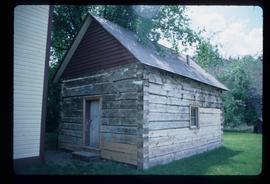
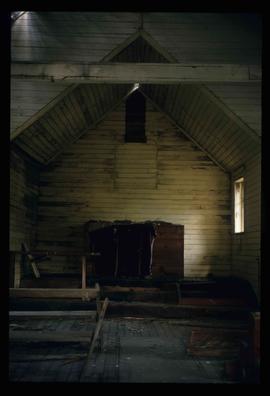
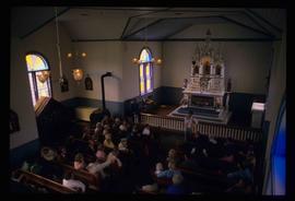
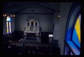
Image depicts the altar inside the St. Joseph's Roman Catholic Church in Kamloops, B.C.
File contains slides depicting buildings and places in and around Ashcroft, Kamloops, and Hat Creek, B.C.
Image depicts the corner of an old log building in Deadman Creek, near Kamloops, B.C.
Image depicts the McLean Cabin, built in 1861, which belonged to a retired Hudson's Bay Chief trader named Donald McLean, who was shot and killed while part of a posse that was searching for the murderers of a survey party. It is located at the historic Hat Creek Ranch site north of Ashcroft, B.C.
Image depicts an old barn on the historic Hat Creek Ranch site north of Ashcroft, B.C.
Image depicts a "box barn" on the historic Hat Creek Ranch site north of Ashcroft, B.C.
File consists of notes, clippings, and reproductions relating to the Pacific Great Eastern Railway line. Includes: "Remembering" special edition of the Coupler Marking the 75th anniversary of BC Rail and the PGE Railway (Jan. 1987). Also includes a photograph depicting the Ahbau railway bridge (2005).
File consists of notes, clippings, and reproductions relating to the history of Prince George from 1950-1959. Includes the following clipped articles from the Prince George Citizen newspaper: "Mid-century optimism buoyed Prince George's business prospects" (May 2008); "The simple life - 1950s style" (Apr. 2007); "Prince George's firsts in the '50s" (June 2004); "Here's a look at our town in the early 1950s" (Sept. 1987); "1952 - An eventful year for Prince George citizens" (Mar. 2003); and "Bennett's two river policy helped develop the North" (22 July 2000).
File contains slides depicting places in and around the Kamloops and Lillooet regions.
Image depicts numerous grave markers at an uncertain location.
Image depicts the old Kamloops Residential School which operated until either 1977 or 1978 before becoming part of the Secwepemc Musem in 1982.
Image depicts a representation of the crucified Christ in the St. Joseph's Roman Catholic Church in Kamloops, B.C.
Image depicts a church in Deadman Creek, west of Kamloops, B.C.
Image depicts the welcome sign of the historic Hat Creek Ranch site north of Ashcroft, B.C.
The item is a photograph of the industrial area off of Queensway in Prince George.
The item is a photograph of a house in the industrial area off of Queensway in Prince George.
File contains slides depicting the Kootenay Plains and surrounding areas in Alberta.
Image depicts the interior of an abandoned, deteriorating cabin on Blackwater Road.
Image depicts an abandoned, deteriorating cabin on Blackwater Road.
Image depicts an abandoned cabin and shed on Blackwater Road.
Image depicts the McBride CNR station.
Image depicts a small graveyard at an uncertain location.
Image depicts a red carriage labelled in yellow "B.C. Express Co. No. 20." It is possibly located in Kamloops, B.C.
Image depicts a large crowd of people seated inside the St. Joseph's Roman Catholic Church in Kamloops, B.C.
Image depicts a tombstone, with the name and inscription written in what appears to be Chinese. It is most likely located somewhere in or near Kamloops, B.C.
Image depicts two children in front of an old log building on the Deadman Creek reserve, located west of Kamloops, B.C.
Image depicts numerous individuals standing near the Ranch house and McLean Cabin on the historic Hat Creek Ranch site north of Ashcroft, B.C.
Image depicts several individuals sitting on the front porch of the Ranch house on the historic Hat Creek Ranch site north of Ashcroft, B.C.
Image depicts the road leading to the historic Hat Creek Ranch site north of Ashcroft, B.C. Several individuals are sitting on the front porch of the Ranch house.
Image depicts what appears to be a mud house with grass and weeds growing on the roof at an uncertain location. An unknown woman is sitting on a bench outside of it.
File consists of "South Fort George: A trip to the past", a heritage brochure prepared by the South Fort George Community Association.
The item is a photograph of a house in the industrial area off of Queensway in Prince George.
The item is a photograph of a house in the industrial area off of Queensway in Prince George. Annotation on back of photograph sates, "2 doors east."
Image depicts a shed on Blackwater Road.
Image depicts the McBride CNR station.
Item is an original 1987 map depicting Saxton Lake in British Columbia, published by the Department of Energy, Mines and Resources Ottawa, Canada. The map includes pen markings.
File consists of clippings, notes, and reproductions relating to the women Margaret Seymour (Granny Seymour), Six Mile Mary (Mary Quaw), and Margaret Gagnon. Includes: "Interview by University Women's Club" transcript of an interview of Marguerite Marie Gagnon (4 May 1987).
File consists of a "BC Rail" special edition of the Prince George Citizen newspaper celebrating 75 years of railway (21 May 1987).
File consists of notes, letters, and reproductions relating to the "Arrival of Steel" CN Railway plaque in Prince George. Includes: "Invitation" from the City of Prince George for the unveiling of the CN plaque (27 Jan. 1989) and correspondence letters between CN and the City of Prince George (1987-1989). Also includes photographs depicting the CN plaque and the unveiling ceremony (Jan. 1989).
File consists of notes, reproductions, and letters relating to L.C. Gunn Park in Prince George. Includes: "Signage for Gunn Park" letter from Kent Sedgwick to the Mayor and Council (21 Dec. 1989); "L.C. Gunn viewpoint a proposal" documents within a duotang (1987); and "Donation to the City of Prince George" typescript letter from Graham Farstad to the Administration Committee ( 1 June 1988). Includes photographs depicting the opening of L.C. Gunn Park and the sign unveiling (3 Oct. 1988).
File consists of notes, reproductions, and typescript documents relating to Beaverly Elementary School. Includes: "Beaverly School" typescript letter from Kent Sedgwick to the Beaverly Community Association (30 Oct. 1987). Also includes photographs depicting the old weathered wooden Beaverly School building (Nov. 2001).
Image depicts a ferry entering Horseshoe Bay in the Howe Sound region.
Image depicts a river at an uncertain location in either the Lillooet or Kamloops area.
Image depicts Sue Sedgwick standing next to a camper.
Image depicts Sue Sedgwick standing on the bank of a river.
Image depicts the interior of an old, abandoned church at an uncertain location; possibly somewhere between Lillooet and Kamloops.
Image depicts what is possibly either the Fraser or the Thompson River.