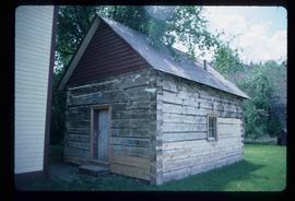
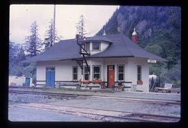
The item is a photograph depicting an old, abandoned wooden house on Holzworth homestead in the Fort George Canyon.
The item is a photograph depicting the Fraser River running through the Fort George Canyon.
The item is a photograph depicting an old, abandoned wooden house on the Holzworth homestead in the Fort George Canyon.
The item is a photograph depicting the Fraser River running through Fort George Canyon.
File consists of notes, reproductions, clippings, and letters relating to the Junkers aircraft named "The City of Prince George," registration CF-ALX. Includes: "Western Canada Aviation Museum" letter to Dennis McCallum from Karen Schmidt (25 June 1986) and "City of Prince George Junkers F-13 Airplane" typescript document (4 Sept. 1986).
File consists of notes, clippings, and reproductions relating to Sinclair Mills, a community along the East Line. Includes material regarding the development of a sawmill in Sinclair Mills and life in the community. Includes "Interview with Louisa Mueller" typed transcript of an interview with Louisa Mueller regarding her life at Sinclair Mills (29 Oct. 1999). File also includes photographs depicting various Sinclair Mills buildings, including of the silo and bunkhouse (2009-2010).
File contains slides depicting Chemanus, B.C.
The item is a photograph depicting the Europe Hotel site located at Lot 8, Block 133, Plan 1268, D.L. 343. The photograph is a view of 3rd Avenue looking east from the site. Annotation states, "Photos Taken in March 86."
The item is an architectural plan that depicts landscaping plans to replace the Europe Hotel. Plans include all the supplies needed for landscaping as well as plans for building the structures to be placed in the lot. The plans were drawn by G. Fleming.
Image depicts an aerial view of Fort George Park.
Image depicts a canoe on the Fraser Lake.
The item is a photograph depicting the Europe Hotel site located at Lot 8, Block 133, Plan 1268, D.L. 343. The photograph is a view of an adjacent building to the lot. There is a yellow car parked on the lot. Annotation states, "Photos Taken in March 86."
The item is a photograph depicting the Europe Hotel site located at Lot 8, Block 133, Plan 1268, D.L. 343. The photograph is a view of an adjacent building to the lot. Three vehicles are parked in the lot. Annotation states, "Photos Taken in March 86."
File consists of notes, clippings, and reproductions relating to the Cariboo and Northwest Digest publication. Also includes a CD-R that contains Sedgwick's index spreadsheet and accompanying documentation about the publication.
Item is an original 1986 map depicting Salmon Valley in British Columbia and was published by the Department of Energy, Mines and Resources Ottawa Canada.
File consists of notes, clippings, and reproductions relating to the South Fort George townsite. Includes "Name change from Glenora Park to Paddlewheel Park" typescript letter from Kent Sedgwick to The Mayor and Council (12 Sept. 1988).
File consists of a book and typescript correspondences. Includes: "Tweedsmuir Provincial Park Background Document" by the Province of British Columbia (1986).
File consists of clippings, notes, and reproductions relating to the Hart Highway in Prince George. Also includes "Fraser flats" typescript document by Caroline Buchi.
The item is a photograph depicting the Fraser River running through Fort George Canyon.
The item is a photograph depicting the Fraser River running through Fort George Canyon. Annotation on revers side of the photograph states, "6."
The item is a photograph depicting a dog on the beach along the Fraser River in Fort George Canyon.
The item is a photograph depicting the Fraser River running through the Fort George Canyon.
The item is a photograph depicting an old, abandoned wooden house on the Holzworth homestead in the Fort George Canyon.
The item is a photograph depicting an old, abandoned wooden barn on the Holzworth homestead in the Fort George Canyon.
File consists of notes, clippings, and reproductions relating to the medical history of Prince George. Includes the following clipped articles from the Prince George Citizen newspaper: "From a missionary to state-of-the-art" (July 1986); "Medical practice seen from inside" (May 2007); "Hospital services: the post war era" (June 2004); "Northerners sought hospital expansion" (Jan. 2001); and "The growing need for a local hospital" (Dec. 1999). Also includes photographs depicting the first hospital in Prince George at 1584 8th avenue.
File contains slides depicting buildings and places in and around Ashcroft, Kamloops, and Hat Creek, B.C.
Image depicts the corner of an old log building in Deadman Creek, near Kamloops, B.C.
Image depicts the McLean Cabin, built in 1861, which belonged to a retired Hudson's Bay Chief trader named Donald McLean, who was shot and killed while part of a posse that was searching for the murderers of a survey party. It is located at the historic Hat Creek Ranch site north of Ashcroft, B.C.
Image depicts an old barn on the historic Hat Creek Ranch site north of Ashcroft, B.C.
Image depicts a "box barn" on the historic Hat Creek Ranch site north of Ashcroft, B.C.
Image depicts the Kwinitsa CNR station in Kwinitsa, along the Skeena River.
Image depicts the Kwinitsa CNR station, which is Prince Rupert's railway museum.
Image depicts a ferry on a river, possibly the Fraser River in the Lillooet area.
Image depicts the interior of an old, abandoned church at an uncertain location; possibly somewhere between Lillooet and Kamloops.
Image depicts an old and abandoned, collapsing church at an uncertain location.
Image depicts a close-up of the carriage step. It is possibly located in Kamloops, B.C.
Image depicts a street, possibly in Kamloops, which has been closed for a Sunday morning Farmer's Market.
Image depicts the old Kamloops Residential School which operated until either 1977 or 1978 before becoming part of the Secwepemc Musem in 1982.
Image depicts the St. Joseph's Roman Catholic Church, in Kamloops, B.C.
Image depicts the altar inside the St. Joseph's Roman Catholic Church in Kamloops, B.C.