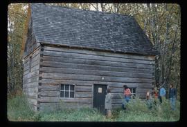
Print preview Close

Showing 2444 results

Archival description
1595 results with digital objects Show results with digital objects
2012.13.1.87.065 · Stuk · [between 1975 and 1995]
Part of J. Kent Sedgwick fonds

Image depicts an old house for sale surrounded by overgrown bushes in Upper Fraser, B.C. Map coordinates 54°07'15.0"N 121°57'02.0"W

2012.13.1.87.067 · Stuk · [between 1975 and 1995]
Part of J. Kent Sedgwick fonds

Image depicts a row of buildings in Upper Fraser, B.C. with the store (titled "Paradise") with a Pepsi sign. Map coordinates 54°07'09.1"N 121°56'47.0"W

Open Field in Giscome
2012.13.1.87.068 · Stuk · [between 1975 and 1995]
Part of J. Kent Sedgwick fonds

Image depicts a field in Giscome, B.C. On the right side of the image, in the background, is a grey strip that appears to be a mine, possibly the quarry at Eaglet Lake in Giscome, B.C. Map coordinates 54°03'52.9"N 122°22'10.0"W

2012.13.1.87.104 · Stuk · [between 1975 and 1995]
Part of J. Kent Sedgwick fonds

Image depicts a snowy street in Willow River, B.C. There are several buildings, one is an Esso station and another is labelled as "Red & White Food Store."

Willow River Houses
2012.13.1.87.105 · Stuk · [between 1975 and 1995]
Part of J. Kent Sedgwick fonds

Image depicts a snowy street in Willow River, B.C. with a row of houses. The white building on the end with the Pepsi sign is the Willow River General Store. Map coordinates 54°04'18.3"N 122°28'14.7"W

River and Snow
2012.13.1.87.154 · Stuk · [between 1975 and 1995]
Part of J. Kent Sedgwick fonds

Image depicts what appears to be a small, narrow river, and mounds of snow. The location is uncertain.

Giscome Bunkhouse
2012.13.1.87.158 · Stuk · [between 1975 and 1995]
Part of J. Kent Sedgwick fonds

Image depicts the Giscome bunkhouse in Giscome, B.C. Map coordinates 54°04'17.6"N 122°22'06.1"W

Giscome Community Hall
2012.13.1.87.160 · Stuk · [between 1975 and 1995]
Part of J. Kent Sedgwick fonds

Image depicts the Giscome Community Hall in Giscome, B.C. Map coordinates 54°04'18.5"N 122°21'57.7"W

Giscome Dock and Wood Scraps
2012.13.1.87.166 · Stuk · [between 1975 and 1995]
Part of J. Kent Sedgwick fonds

Image depicts a dock at an inlet of Eaglet Lake in Giscome, B.C. There are numerous logs and other pieces of wood scattered in the foreground. Map coordinates 54°04'34.9"N 122°21'50.0"W

Giscome Sawmill
2012.13.1.87.168 · Stuk · [between 1975 and 1995]
Part of J. Kent Sedgwick fonds

Image depicts the mill site at Giscome, B.C. Map coordinates 54°04'19.7"N 122°22'04.7"W

Giscome Sawmill
2012.13.1.87.170 · Stuk · [between 1975 and 1995]
Part of J. Kent Sedgwick fonds

Image depicts the mill site at Giscome, B.C. Map coordinates 54°04'19.7"N 122°22'04.7"W

Giscome Parking Lot
2012.13.1.87.174 · Stuk · [between 1975 and 1995]
Part of J. Kent Sedgwick fonds

Image depicts a parking lot full of vehicles with the Giscome store in the background. Map coordinates 54°04'18.5"N 122°21'57.7"W

Giscome Sawmill
2012.13.1.87.176 · Stuk · [between 1975 and 1995]
Part of J. Kent Sedgwick fonds

Image depicts the Giscome, B.C. mill site looking west. Map coordinates 54°04'18.5"N 122°21'57.7"W

Newlands?
2012.13.1.89.028 · Stuk · Mar. 1975
Part of J. Kent Sedgwick fonds

Image depicts what is possibly the community of Newlands, B.C.

Modern Forestry
2012.13.1.122 · Deelreeks · [between 1975 and 1982]
Part of J. Kent Sedgwick fonds

File contains slides depicting logging and equipment. Most appear to be locations around Prince George.

Sawmill - Lakeland Mills?
2012.13.1.122.07 · Stuk · Oct. 1975
Part of J. Kent Sedgwick fonds

Image depicts a saw mill, possibly Lakeland Mills, with a beehive burner and numerous piles of logs in the foreground, in Prince George, B.C.

Suspended Trailer
2012.13.1.122.09 · Stuk · Oct. 1975
Part of J. Kent Sedgwick fonds

Image depicts a trailer for a logging truck suspended off the ground by a wooden structure. This is used to load the trailer onto the back of the truck. The name on the truck says "Rormarniewich Trucking Ltd."

Skier in a Costume
2012.13.1.129.05 · Stuk · 1975
Part of J. Kent Sedgwick fonds

Image depicts a skier in a costume with a fake sword, somewhere on the Birchleg Ski route on Tabor Mountain in Prince George, B.C.

Giscome Station
2012.13.1.6.034 · Stuk · May 1975
Part of J. Kent Sedgwick fonds

Image depicts the old Giscome Train Station in Giscome, B.C. It was demolished between 1976 and 1977.

Northern Rooms
2012.13.1.7.002 · Stuk · Oct. 1975
Part of J. Kent Sedgwick fonds

Image depicts an old building with a sign labelled "Northern Rooms" in an uncertain location somewhere in Prince George, B.C.

Fraser Lake Cabin
2012.13.1.12.02 · Stuk · Oct. 1975
Part of J. Kent Sedgwick fonds

Image depicts a cabin at Fraser Lake, B.C. which is labelled on the slide as an example of a "square log" dovetail joint.

Loos
2012.13.1.86.09 · Stuk · 1975
Part of J. Kent Sedgwick fonds

Image depicts several buildings in the community of Loos, B.C.

2012.13.1.87.004 · Stuk · [between 1975 and 1995]
Part of J. Kent Sedgwick fonds

Image depicts several eighteen wheelers at the Pass Lake Road and Upper Fraser Road intersection with numerous houses and buildings in the background in McGregor, B.C. Map coordinates 54°04'38.1"N 121°50'00.1"W

Houses and Three Goats
2012.13.1.87.021 · Stuk · [between 1975 and 1995]
Part of J. Kent Sedgwick fonds

Image depicts several houses, and three goats standing on a narrow dirt road. The location is uncertain, likely Sinclair Mills, B.C.

Shacks and a Mountain
2012.13.1.87.028 · Stuk · [between 1975 and 1995]
Part of J. Kent Sedgwick fonds

Image depicts two old shacks and a mountain in the background. Possibly located in or near Longworth, B.C.

Cabin
2012.13.1.87.038 · Stuk · [between 1975 and 1995]
Part of J. Kent Sedgwick fonds

Image depicts a cabin at an uncertain location.