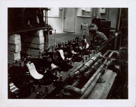
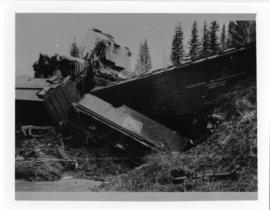
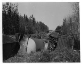
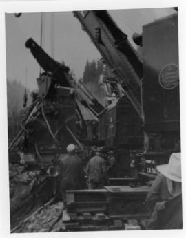
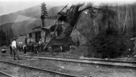
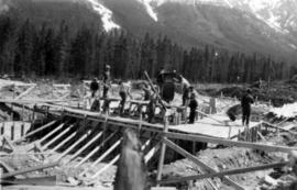
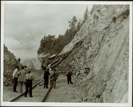
Photograph depicts 9 men working on building speculated to be foundation for diesel engine. (See also items 2000.1.1.2.216 and 2000.1.1.2.217).
Photograph depicts the Cassiar mine. North peak featured in left background, South peak in right background, and West peak in right foreground. Area to left of the mining pit and West peak was called the "cirque waste dump." Location of new mine garage can be seen just above the "#7 switchback" road in bottom right foreground.
Photograph depicts unknown man driving bulldozer on edge of mine area at high elevation. The dozer is an International model TD24 (manufactured between 1947 and 1955). A second man stands on edge of cliff, directing driver. Expansive mountain range in background.
Photograph depicts an unidentified individual wearing a welding helmet, and kneeling behind large bearing cups of one of the Ruston Hornsby diesel engines that turned the generators in the power house on the Cassiar plant. Door, bulletin board, and miscellaneous supplies in background.
Photograph depicts the large bearing cups of one of the Ruston Hornsby diesel engines that turned the generators in the power house on the Cassiar plant. Engine believed to be under repair. Electric panels in background.
Photograph depicts large Caterpillar engine in large shop with sheeted walls and brick floor. Accompanying note reads: "MTCE 4-01 (b) Cat 3612 Engine".
Photograph depicts large Caterpillar engine against painted brick wall in building with brick floor. Miscellaneous equipment in background. Accompanying note reads: "MTCE 4-01 (b) Cat 3612 Engine".
Photograph depicts tower and bucket tram in left foreground, plantsite in midground, mountains across valley in background. Dry rock storage building, mill, tailings pile, and many other buildings visible in plantsite. Handwritten annotation on verso of photograph: "1961".
Photograph depicts three women wearing matching attire in doorway of CP Air plane on runway. Small plane in foreground, field and trees in background. Handwritten annotation on verso of photograph: "Watson Lake June 14 71".
Photograph depicts plant buildings in front of tailings pile in midground. Forest, power line, and tramline in foreground; south mountains in background.
Photograph depicts group of unidentified men seated in bus seats, wearing work clothes and hard hats. Believed to be taken on mine bus which ran between the plant and mine (see also item 2000.1.1.3.19.70).
Photograph depicts mine area. Switchback road and higher benches in background. Blasthole drills, track shovels, and ore haulage trucks can be seen on level in foreground and higher bench in background. Mountains visible in distance. Benches in background speculated to be located on the mine's West Peak.
Photograph depicts wheel bulldozer in snowy unknown area of mine.
Photograph depicts machinery in snowy area of mine. Euclid ore haulage truck in foreground, cassiar pickup truck visible in lower area in midground. Blasthole drill in front of track shovel in left background, Wabco ore haulage truck visible behind other machinery in right background.
Photograph depicts the Cassiar mine on McDame Mountain. West peak semi-visible in foreground. Drills and ore haulage trucks visible below in pit and on switchback roads.
Photograph depicts the Cassiar mine on McDame Mountain. Blasthole drills and ore haulage trucks visible below in open pit and on switchback road.
Photograph depicts blasthole drill on left, bulldozer in centre, and shovel loading ore haulage truck in background. Second haul truck is semi-visible on far right. Hose equipment can be seen in foreground.
Photograph depicts a shovel loading what appears to be a Euclid ore haulage truck in excavation area of mine.
Photograph depicts a Euclid ore haulage truck dumping material on pile in left foreground.
Photograph depicts crusher buildings in left foreground, located west of mine on McDame Mountain. Southeast mountain range in background.
Photograph depicts what appears to be a Euclid ore haulage truck at entrance of building speculated to be the truck dumping station at crusher plant in mine.
Photograph depicts ore cars on cables running between tramline towers on left. Road in right foreground, building and McDame mountain in background. Tramline ran through mine valley, between loading station in mine and dump station at mill on plantsite.
Photograph depicts pallets of fibre bags in shipping area (believed to be in mill building).
Photograph depicts unidentified man operating forklift. Pallets of asbestos fibre sit on trailer in background. Believed to have been taken in shipping area of mill building.
Photograph depicts large trailer truck parked at what is believed to be the loading station on the Cassiar plant (possibly in mill building).
Photograph depicts two large tanks with Cassiar logo on front, labeled "1" and "2". Road in foreground, garage in background. Mountain base also visible in background.
Item is a photograph of Mr. Williston and his son Dr. Hubert Williston in May 1967 canoeing down the Parsnip / Peace system before the W.A.C. Bennett Dam flooded the area.
Item is a photograph of Ray Williston in flight gear.
Item is a photograph of a bulldozer removing debris from train tracks on August 27, 1956 location unknown.
Item is a photograph of people, mostly children looking at a helicopter in a field.
Item is a photograph of people fishing in a boat with nets.
Item is a photograph of people climbing on top of a bus.
Item is a photograph of people in a boat on a river with another boat in the background.
The Fyfe Lake Sawmill series consists of administrative, financial, and operational records created by Fyfe Lake Sawmills. The series includes labour, logging, sale, and order records. Also comprises correspondence between Fyfe Lake Fir and a number of individuals, organizations and companies. Records created by the Northern Interior Lumberman’s Association, equipment manuals, and instructional publications that were collected and used by Fyfe Lake are also included.
Fyfe Lake SawmillPhotograph depicts a Canadian National Railway train derailment.
Photograph depicts a Canadian National Railway train derailment. Location is unknown.
Photograph depicts Canadian National Railway steam cranes at work. Three railwaymen are in the foreground.
Photograph depicts 3 unnamed railway employees posing for a photograph in front of a railroad station in an unknown location.
Photograph depicts Grand Trunk Pacific locomotive 624 and equipment at a railyard.
Photograph depicts construction of a Grand Trunk Pacific Railway trestle by Bostrom & Green Contractors near Fort Fraser, BC.
Photograph depicts what is possibly a Canadian National Railway steam shovel digging alongside railway tracks with onlooking railway workers.
Photograph depicts two unknown men walking on rocky shore with canoe over their heads. Water and forest in background. Handwritten annotation visible on negative: "[?] portaging canoe".
Image is one of 65 photos documenting a survey of the Canada-Alaska Boundary, Taku River area, May 23 to Oct. 15, 1906.
This particular photo is one of 8 found in original enclosure with the following handwritten annotation: "From main camp up Kopoka River. Scenes with persons in." See also items 2006.20.3.14 - 2006.20.3.21.
Photograph depicts two men paddling in canoe, shore in background. Handwritten annotation visible on negative reads: "Stughes & B_ Lake behind Main Camp Taku River".
Image is one of 65 photos documenting a survey of the Canada-Alaska Boundary, Taku River area, May 23 to Oct. 15, 1906.
This particular photo is one of 13 found in original enclosure with the following handwritten annotation: "SOME OTHERS." See also items 2006.20.3.22 - 2006.20.3.34.
Photograph depicts two men climbing up snowy area with walking poles and other gear. Handwritten annotation visible on negative: "Nellis & Gilroy Snow [?] - No.3."
Image is one of 65 photos documenting a survey of the Canada-Alaska Boundary, Taku River area, May 23 to Oct. 15, 1906.
This particular photo is one of 13 found in original enclosure with the following handwritten annotation: "SOME OTHERS." See also items 2006.20.3.22 - 2006.20.3.33.
Photo description on accompanying photo album page: "The bungalow-like Administration Building under construction at Teslin Lake, Yukon Territory. The top portion will be the control tower."
Photograph depicts Slim Williams and four members of his dog team in the centre of the image, with a group of men, women and children standing behind him looking towards the camera. Handwritten annotation along bottom of photograph reads: "'Slim' Williams and Dog Team From Alaska to Chicago 1933". It is believed this photograph was taken in Hazelton, BC. and documents Slim Williams on his way to the Chicago Fair.
Two men stand on the ice of Pinchi Lake beside a small plane that appears to have crashed into the icy lake. Handwritten annotation in ink on the verso reads: "Plane on the ice at Pinchi".
Photograph depicts sternwheeler passing through rapids of the Fraser River, B.C. Printed annotation on recto reads: “The B.C. Express Passing through the Grand Canyon B.C.”, handwritten in red ink: “1913”.
Postcard photograph depicts sternwheeler, men visible on deck, hills on opposite shore in background.
Printed annotation on recto reads: “B.C. Express Steamer, Fraser River.” Handwritten annotation in pencil on verso reads: “BC Express Fraser River BC”.
Rocks and trees on either shore.
Printed annotation on recto reads: “Steamer B.X. Monarch of New B.C. Soda Creek, Quesnel and Fort George”