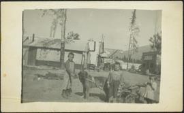
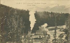
Affichage de 81 résultats

Archival description
79 résultats avec objets numériques Afficher les résultats avec des objets numériques
Canoe Pass at Fort George Canyon, BC
2009.5.3.64 · Pièce · [ca. 1913]
Fait partie de Taylor-Baxter Family Photograph Collection

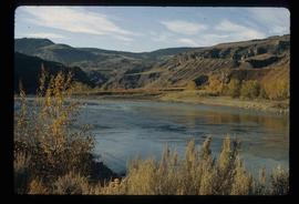
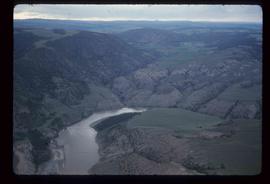
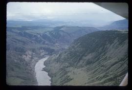
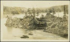
Photograph depicts a small pass through an island or peninsula on the Fraser River. Photo is believed to have been taken near Stone Creek, south of South Fort George. Annotation on verso of photograph reads: "FORT GEORGE CANYON. CANOE PASS. J. HEAY. PHOTO."

Houghtaling Family at Sand Creek, BC
2009.5.3.73 · Pièce · 1912
Fait partie de Taylor-Baxter Family Photograph Collection

Photograph depicts three small children (Henry, Charlie and Mary) standing at Sand Creek settlement. A dog stands beside them pulling a small wagon of firewood. Tent and wood buildings in background, including a cafe on far right. Hillside can be seen in distance. Handwritten annotation on recto of photograph reads: "Houghtaling Sand Creek Bourchier 1912".

Fraser River - Bridge
2012.13.1.52.44 · Pièce · [1980?]
Fait partie de J. Kent Sedgwick fonds

Image depicts a bridge over the Fraser River in the Upper Fraser Canyon; possibly near Gang Ranch.

Fraser River
2012.13.1.53.06 · Pièce · June 1974
Fait partie de J. Kent Sedgwick fonds

Image depicts a view of the Fraser River near Lillooet, B.C.

Moran Canyon
2012.13.1.53.23 · Pièce · Mar. 1975
Fait partie de J. Kent Sedgwick fonds

Image depicts the Fraser River running through the Moran Canyon near Lillooet, B.C.

Moran Canyon
2012.13.1.53.48 · Pièce · July 1982
Fait partie de J. Kent Sedgwick fonds

Image depicts a view of Moran Canyon in the Lillooet area. The Fraser River is visible on the left.

Slump or Mining
2012.13.1.65.34 · Pièce · June 1975
Fait partie de J. Kent Sedgwick fonds

Image depicts an aerial view of a section of land, likely near the Fraser River, that is possibly either a slump or part of a mining operation. The slide is labelled "slump or mining."

Landscape - Fraser River
2012.13.1.65.38 · Pièce · June 1975
Fait partie de J. Kent Sedgwick fonds

Image depicts an aerial view of the land near the Fraser River. The Fraser River is barely visible on the right side of the image.

Rock Formations
2012.13.1.65.52 · Pièce · [1976?]
Fait partie de J. Kent Sedgwick fonds

Image depicts ridge-like rock formations at an uncertain location, though possibly somewhere near the Fraser River.

Fraser Valley
2012.13.1.50.066 · Pièce · 1978
Fait partie de J. Kent Sedgwick fonds

Image depicts the Fraser Valley, looking north, possibly from Marguerite, B.C.

Bob Potts Cooking in Campsite
2009.5.3.33 · Pièce · [ca. 1913]
Fait partie de Taylor-Baxter Family Photograph Collection

Photograph depicts six men around fireside in forest, trees felled on either side. Bob Potts sits on far right, next to dog in foreground. These men are believed to be members of A. K. Bourchier's crew on the Upper Fraser River. Handwritten annotation on recto of photograph: "Preparing The miday meal. frying Bacon on sticks. Potts. Chief Chef."

Houghtaling Family by Tent Building
2009.5.3.74 · Pièce · 1912
Fait partie de Taylor-Baxter Family Photograph Collection

Photograph depicts Mrs. Houghtaling standing with four small children near doorway of tent building (Gertrude, Mary, Henry, and Charlie). This photograph is believed to have been taken at Sand Creek, BC. Forest trees in background. Handwritten annotation on recto of photograph reads: "Tete Jaune 1912".

Fraser River
2012.13.1.53.03 · Pièce · Aug. 1971
Fait partie de J. Kent Sedgwick fonds

Image depicts the Fraser River somewhere in the Lillooet area.

Moran Canyon
2012.13.1.53.19 · Pièce · Mar. 1975
Fait partie de J. Kent Sedgwick fonds

Image depicts the Fraser River running through the Moran Canyon near Lillooet, B.C.

Moran Canyon
2012.13.1.53.24 · Pièce · Mar. 1975
Fait partie de J. Kent Sedgwick fonds

Image depicts the Fraser River running through the Moran Canyon near Lillooet, B.C.

Lillooet - Bridges
2012.13.1.53.44 · Pièce · July 1982
Fait partie de J. Kent Sedgwick fonds

Image depicts two bridges over the Fraser River, located somewhere in Lillooet, B.C.

Fraser River
2012.13.1.50.065 · Pièce · 1978
Fait partie de J. Kent Sedgwick fonds

Image depicts the Fraser River, looking south from Marguerite, B.C.

Farm
2012.13.1.50.067 · Pièce · 1978
Fait partie de J. Kent Sedgwick fonds

Image depicts a farm on the west side of the Fraser, south of Quesnel, B.C.

"Fraser Gold"
2006.9.6 · Dossier · c.1990 - c.2000
Fait partie de Bob Harkins fonds

File consists of 1 VHS recording entitled "Fraser Gold," produced by the Fraser River Discovery Centre.

Sand Creek on Fraser River, BC
2009.5.3.72 · Pièce · [ca. 1912]
Fait partie de Taylor-Baxter Family Photograph Collection

Photograph depicts small log buildings and loaded wagons in cleared dirt area. Building on far left has the sign "POOL HALL" posted on front . Treetops, lumber piles, and hills in background. Mountains can be seen in distance. Handwritten annotation on verso of photograph reads: "Sand Creek. B.C."

Grooving
2012.13.1.65.40 · Pièce · June 1975
Fait partie de J. Kent Sedgwick fonds

Image depicts an aerial view of grooves in the land near the Fraser River, possibly caused by glaciers.

Grooving
2012.13.1.65.42 · Pièce · June 1975
Fait partie de J. Kent Sedgwick fonds

Image depicts a view of grooves in the land near the Fraser River, possibly caused by glaciers.