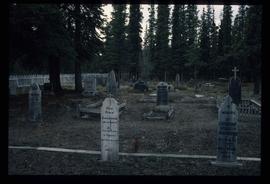
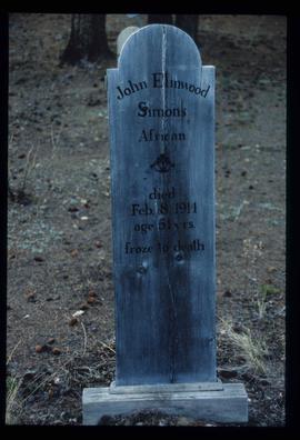
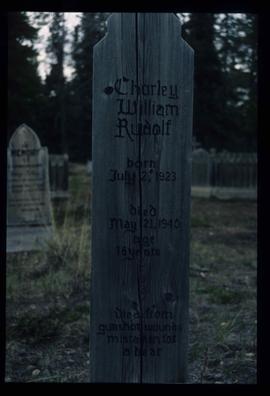
Showing 2133 results

Archival description
1985 results with digital objects Show results with digital objects
Atlin - the Tarahne
2012.13.1.98.29 · Item · 1999
Part of J. Kent Sedgwick fonds

Image depicts a boat named "the Tarahne," which is located in Atlin, B.C. Atlin Lake and Mountain are visible in the background.

Atlin - A Dock
2012.13.1.98.31 · Item · 1999
Part of J. Kent Sedgwick fonds

Image depicts a dock on the shore of Atlin Lake, as well as a building that may have once been a hospital. The slide is simply labelled "hospital."

Atlin - the Tarahne
2012.13.1.98.32 · Item · 1999
Part of J. Kent Sedgwick fonds

Image depicts a boat named "the Tarahne," which is located in Atlin, B.C. Atlin Lake and Mountain are visible in the background.

Atlin Road?
2012.13.1.98.43 · Item · 1999
Part of J. Kent Sedgwick fonds

Image depicts what is possibly Atlin Road. Numerous mountains are visible in the distance.

Atlin Lake?
2012.13.1.98.46 · Item · 1999
Part of J. Kent Sedgwick fonds

Image depicts what is possibly Atlin Lake, with numerous mountains in the distance and Atlin Mountain visible on the right of the image.

Miles Canyon? - Trees
2012.13.1.98.57 · Item · 1999
Part of J. Kent Sedgwick fonds

Image depicts numerous trees on the bank of a river, possibly in Miles Canyon near Whitehorse, Y.T. The slide is labelled "canyon city."

Alaska Highway
2012.13.1.98.59 · Item · 1999
Part of J. Kent Sedgwick fonds

Image depicts a small section of the Alaska Highway somewhere near Whitehorse, Y.T. The slide also appears to be labelled "army washing" for unknown reasons.

Eroding Rock Face?
2012.13.1.98.60 · Item · 1999
Part of J. Kent Sedgwick fonds

Image depicts what appears to be an eroding rock face. The slide itself is labelled "ash loger at top" for unknown reasons. Possibly located somewhere near Whitehorse, Y.T.

Miles Canyon - the Schwatka
2012.13.1.98.61 · Item · 1999
Part of J. Kent Sedgwick fonds

Image depicts numerous unidentified individuals getting off a boat which bears the name "Schwatka." It is located somewhere in Miles Canyon.

Miles Canyon - A River
2012.13.1.98.65 · Item · 1999
Part of J. Kent Sedgwick fonds

Image depicts a river in the Miles Canyon near Whitehorse Y.T. The Robert Lowe Bridge, built in 1922, can be seen over the canyon.

Highway and Mountains
2012.13.1.98.68 · Item · 1999
Part of J. Kent Sedgwick fonds

Image depicts a van on a highway with mountains in the distance; the location is uncertain, though it is possibly along the Alaska Highway.

Highway and Mountains
2012.13.1.98.70 · Item · 1999
Part of J. Kent Sedgwick fonds

Image depicts a van on a highway with mountains in the distance; the location is uncertain, though it is possibly along the Alaska Highway.

A Bear
2012.13.1.98.71 · Item · 1999
Part of J. Kent Sedgwick fonds

Image depicts a bear, possibly a grizzly. The location is uncertain.

South Fort George townsite
2012.13.2.02.47 · File · 1986-2006
Part of J. Kent Sedgwick fonds

File consists of notes, clippings, and reproductions relating to the South Fort George townsite. Includes "Name change from Glenora Park to Paddlewheel Park" typescript letter from Kent Sedgwick to The Mayor and Council (12 Sept. 1988).

Grand Canyon of the Fraser
2012.13.2.03.04 · File · 1995-2004
Part of J. Kent Sedgwick fonds

File consists of notes, clippings, and reproductions relating to the Grand Canyon of the Fraser River. The Grand Canyon of the Fraser is a short gorge on the upper Fraser River, about 6 kilometres south-southwest of Hutton. The canyon head was about 171 kilometres by river from Fort George, and is about 100 kilometres due east of downtown Prince George.

Agriculture in Prince George
2012.13.2.07.02 · File · 1983-2007
Part of J. Kent Sedgwick fonds

File consists of notes, clippings, and reproductions relating to historical agriculture in Prince George. Includes material on the Prince George Farmer's Institute; experimental plots surrounding Prince George; farming in areas surrounding Prince George including Pineview, Mud River, and Blackburn; ranching; gardening; and the Prince George Experimental Farm. Includes: "Moose in British Columbia, Canada" an educational pamphlet from the Fish and Wildlife Branch of the Department of Recreation and Conservation in British Columbia.

Dairies in Prince George
2012.13.2.07.03 · File · 2004-2006
Part of J. Kent Sedgwick fonds

File consists of notes, clippings, and reproductions relating to dairying and dairy farming in Prince George. Includes material on Harry Moffat; cattle in Mud River; Mr. Hewlett and Centralia Dairy (established in 1923); Interior Creamery, located at the corner of Brunswick and First Avenue; and pasteurization.

2012.13.2.08.03.2 · Item · [ca. 1978]
Part of J. Kent Sedgwick fonds

The item is a photograph depicting a garbage pile at the Railway Museum area prior to being built. Attached note on picture states, "Present location of Railway Museum. Infamous garbage pile dumped in Cottonwood Island Park by CNR. Circa 1978."

2012.13.2.09.03 · File · 1967-2005
Part of J. Kent Sedgwick fonds

File consists of notes, clippings, and reproductions relating to British Columbia historical bibliographies and reference material. Includes: "Rural British Columbia: A Bibliography of Social and Economic Research" typescript document compiled by Dean S. Goard (1967); "Photo chronicler of B.C. a century ago" clipped article from Canadian Photography magazine (Feb. 1977); and "A Guide to British Columbia Stop of Interest Plaques" pamphlet by the Parks Branch of British Columbia (1969).

2012.13.2.11 · Subseries · 1937-2011
Part of J. Kent Sedgwick fonds

Subseries consists of materials collected by Kent Sedgwick for research on the geography and natural resources in Prince George and its region. Includes material on the natural resource industry, including the opening of the McArthur Sawmill, the W. Lamb and Sons Lumber Sawmill, and mining; photocopied aerial photographs of Prince George; the climate, temperatures, and flooding; and the geographical features of Prince George.

Prince George climate
2012.13.2.11.08 · File · 1984-2005
Part of J. Kent Sedgwick fonds

File consists of notes and reproductions relating to climate in Prince George. Includes: "Annual meteorology summary Prince George, B.C". document from Environment Canada (1989).

2012.13.2.11.10 · File · 1983
Part of J. Kent Sedgwick fonds

File consists of notes, clippings, and reproductions relating to the Prince George Rivers Committee. Includes: "Report of the Rivers Committee" spiral bound typescript reports submitted to City Council of the City of Prince George (26 Sept. 1983) and "Submission to Rivers Committee by Heritage Advisory Committee" typescript document by Kent Sedgwick (Apr. 1983).

Interior rainforest
2012.13.2.11.13 · File · 2008
Part of J. Kent Sedgwick fonds

File consists of notes, clippings, and reproductions relating to the central interior rainforest and the Ancient Forest/Chun T'oh Whudujut Provincial Park and Protected Area.