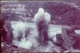
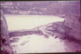
Mostrar 42 resultados

Archival description
39 resultados com objetos digitais Mostrar resultados com objetos digitais
Diversion route for the Peace River
2000.13.1.63 · Item · [between 1962 and 1967].
Parte de Ray Williston fonds

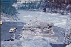
Item is a photograph of the diversion tunnel as engineers plan to blast the plug to allow the Peace River to be diverted for construction of the W.A.C. Bennett Dam.

Explosion of plug for diversion route
2000.13.1.64 · Item · [between 1962 and 1967].
Parte de Ray Williston fonds

Item is a photograph of the explosion which opened up the diversion route for the Peace River during construction of the W.A.C. Bennett Dam.

Construction of diversion route
2000.13.1.65 · Item · [between 1962 and 1967].
Parte de Ray Williston fonds

Item is a photograph of the construction of a temporary river bed to divert the Peace River during construction of the W.A.C. Bennett Dam.

Three diversion tunnels
2000.13.1.66 · Item · [between 1962 and 1967].
Parte de Ray Williston fonds

Item is a photograph of the three tunnels built to divert the Peace River around the Bennett Dam construction site.

The Glassey Album
2009.5.2 · Dossiê/Processo · 1899-01-01 - 1959-12-31
Parte de Taylor-Baxter Family Photograph Collection

This photograph album consists of photographs, membership cards and correspondence of Herbert F. Glassey. Subjects identified in this album include: automobiles, landscape vistas, hunting scenes, snowshoeing, dog sledding, provincial government offices and waterscapes. Identified geographic locations include: Nesutlane Trading Post, Atlin, Teslin Lake, Atlin Lake, McKee Creek, Taku Glacier and Otter Creek. The following of Mr. Glassey’s membership cards are also included within this album: “White Pass & Yukon Route, No. 308: Government Agent, Atlin account, 1939-1940”; “White Pass & Yukon Route, No. 283: Government Agent account, 1941-1942”; “Registration Certificate, 1940”; “The Wartime Prices and Trade Board, no.1305, 1942”; “Dominion Bureau of Statistics, no.252”; “The Society of Notaries Public Membership Card, 1956”; and “Prince Rupert Liberal Association, 1953”.

Sem título
Parle Pas Rapids, Peace River, BC
2009.5.2.52 · Item · [ca. 1910?]
Parte de Taylor-Baxter Family Photograph Collection

Photograph depicts a man standing in a loaded canoe floating close to shore. Two men stand on rocky shore in left foreground. Tall hills in background, river rapids behind canoe in midground. Handwritten annotation on recto of photograph: "Parle Pas Rapids Peace River."

Loading for the Peace River
2009.5.3.158 · Item · [ca. 1910]
Parte de Taylor-Baxter Family Photograph Collection

Photograph depicts six men by building on shore. One man sits in small boat that has been loaded onto a wagon. River and opposite shore in background. Handwritten annotation on verso of photograph: "Loading for the Peace River." Photograph believed to have been taken either at Giscome Portage, or the trading post at Summit Lake, BC.

Peace River
2012.13.1.091 · Subsérie · [between 1974 and 1979]
Parte de J. Kent Sedgwick fonds

File contains slides depicting places along the Peace River.

W.A.C. Bennett Dam
2012.13.1.91.02 · Item · Sep. 1974
Parte de J. Kent Sedgwick fonds

Image depicts a section of the Peace River blocked off by the W.A.C. Bennett Dam. The dam itself is not visible in the image.

Peace River
2012.13.1.91.12 · Item · Oct. 1978
Parte de J. Kent Sedgwick fonds

Image depicts the Peace River, possibly near Clayhurst or Hudson's Hope, B.C.

Peace River
2012.13.1.91.13 · Item · Oct. 1978
Parte de J. Kent Sedgwick fonds

Image depicts the Peace River, possibly near Clayhurst or Hudson's Hope, B.C.

Peace River
2012.13.1.91.23 · Item · Oct. 1978
Parte de J. Kent Sedgwick fonds

Image depicts the Peace River, possibly near Hudson's Hope, B.C.

A Bridge
2012.13.1.91.30 · Item · Oct. 1978
Parte de J. Kent Sedgwick fonds

Image depicts a truck on a bridge, possibly crossing over the Peace River.

People on a Bridge
2012.13.1.91.49 · Item · 1979
Parte de J. Kent Sedgwick fonds

Image depicts several unidentified individuals standing on a bridge; it possibly crosses the peace River.

People and a Bridge
2012.13.1.91.50 · Item · 1979
Parte de J. Kent Sedgwick fonds

Image depicts several unidentified individuals and a bridge behind them; it is possibly crossing the Peace River.

Pine Pass - Peace River
2012.13.1.093 · Subsérie · [between 1978 and 1990]
Parte de J. Kent Sedgwick fonds

File contains slides depicting places in or near Pine Pass and along the Peace River.

Examining Rocks
2012.13.1.93.21 · Item · 1978
Parte de J. Kent Sedgwick fonds

Image depicts three unidentified individuals examining rocks near a set of railway tracks at an uncertain location in the Peace River Region.

Peace River
2012.13.1.93.27 · Item · 1978
Parte de J. Kent Sedgwick fonds

Image depicts the Peace River and visible layers of sediment deposits in the surrounding cliffs.

Peace River
2012.13.1.93.36 · Item · 1978
Parte de J. Kent Sedgwick fonds

Image depicts the Peace River, possibly somewhere near Fort St. John, B.C.

Peace River? - People on a Hill
2012.13.1.93.38 · Item · 1978
Parte de J. Kent Sedgwick fonds

Image depicts a large group of unidentified individuals sitting on a hill; what is possibly the Peace River is visible in the background.

W.A.C. Bennett Dam
2012.13.1.93.61 · Item · Sep. 1984
Parte de J. Kent Sedgwick fonds

Image depicts the W.A.C. Bennett Dam on the Peace River in Hudson's Hope, B.C.