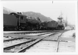
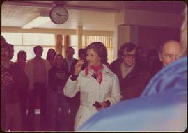
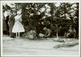
Mostrar 887 resultados

Archival description
887 resultados com objetos digitais Mostrar resultados com objetos digitais
Princess Margaret watching a prospector pan for gold
2000.13.1.25 · Item · 1958
Parte de Ray Williston fonds

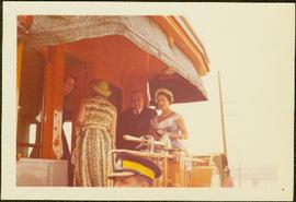
Item is a photograph of Princess Margaret on July 17, 1958 at an event staged in the Prince George railway yards. Alex Moffat dressed as a prospector demonstrates panning for previously salted gold nuggets, which were later given to the Princess.

Prince George Pulp & Paper Company opening ceremonies
2000.13.1.35 · Item · 1966.
Parte de Ray Williston fonds

Item is a photograph of, from left: John G. Prentice of Canadian Forest Products; Peter Bentley of CanFor; Mr. Williston; unknown; Premier W.A.C. Bennett; an unknown representative of Reed Paper and L.L.G. “Poldi” Bentley of Can For.

Princess Margaret arriving in Prince George 2
2000.13.1.115.2 · Item · 1958.
Parte de Ray Williston fonds

Item is a photograph of Princess Margaret arriving by Canadian Air Forces jet at Prince George. Lieutenant-Governor Frank Ross is walking beside the Princess.

Originally mounted on a poster with photographs 115, 115.2, 115.3.

Princess Margaret on a train
2000.13.1.115.3 · Item · 1958.
Parte de Ray Williston fonds

Item is a photograph of Princess Margaret on the back deck of the Royal train's caboose just prior to her departure from Prince George during her 1958 visit to British Columbia.

Originally mounted on a poster with photographs 115, 115.2, 115.3.

2002.1.9.3.003 · Item · [ca. 1958]
Parte de Prince George Railway & Forestry Museum Collection

Photograph depicts the first shipment of sulphur via Pacific Great Eastern Railway August 2nd, 1958. Part of a set of 13 black & white photographs of British Colombia Railway & it's precursor, Pacific Great Eastern Railway (1912 - 2004) in British Columbia. Photos depict locomotives, railroad cars, and crew members. «

Third Ave., Prince George, BC
2011.12.01 · Item · ca. 1950
Parte de Giscome, BC Historical Photograph collection

Photo depicts a street perspective of Third Ave., in Prince George, BC, ca. 1950. Handwritten annotation in pen on verso of postcard reads: “You will undoubtedly notice that there are no tall buildings. I don’t think that there is one building in Prince George that is even five stories tall.”

Yellowhead Bridge
2012.13.1.3.120 · Item · 12 Oct. 1989
Parte de J. Kent Sedgwick fonds

Image depicts the Yellowhead Bridge across the Fraser River. Map coordinates 53°54'45.2"N 122°43'27.9"W

Mr. P.G.
2012.13.1.3.122 · Item · 12 Oct. 1989
Parte de J. Kent Sedgwick fonds

Image depicts Mr. P.G. and the Tourism Information site at the intersection of Highway 16 and 97. Map coordinates 53°53'46.5"N 122°46'00.7"W

Experimental Farm
2012.13.1.3.129 · Item · 13 Aug. 1989
Parte de J. Kent Sedgwick fonds

Image depicts a view of an experimental farm, possibly taken from Tabor Mountain.

Prince George
2012.13.1.3.135 · Item · 12 Oct. 1989
Parte de J. Kent Sedgwick fonds

Image depicts Prince George, possibly with the Northwood Pulpmill in the background.

Pineview
2012.13.1.3.144 · Item · [199-?]
Parte de J. Kent Sedgwick fonds

Image depicts Pineview on Buckhorn Lake Road, Prince George, B.C.

Studio 2880 Arts Complex
2012.13.1.3.170 · Item · Apr. 2003
Parte de J. Kent Sedgwick fonds

Image depicts Studio 2880 Arts Complex in Prince George, B.C. Map coordinates 53°54'36.9"N 122°46'30.3"W

Intercontinental and Prince George Pulp Mills
2012.13.1.5.10 · Item · 6 Sept. 1993
Parte de J. Kent Sedgwick fonds

Image depicts two mills; the Intercontinental Pulp Mill is on the right in the foreground, and the Prince George Pulp and Paper Mill is on the left in the background. The picture is taken from the South, possibly off Yellowhead Bridge in Prince George, B.C.

Spruceland
2012.13.1.5.24 · Item · Mar. 2003
Parte de J. Kent Sedgwick fonds

Image depicts a Lakewood view of Spruceland in Prince George, B.C.

College Heights
2012.13.1.5.25 · Item · Mar. 2003
Parte de J. Kent Sedgwick fonds

Image depicts College Heights, particularly along Gladstone Drive, in Prince George, B.C.

Trailer Park
2012.13.1.5.27 · Item · Mar. 2003
Parte de J. Kent Sedgwick fonds

Image depicts a trailer park by either the Fraser or Nechako River in Prince George, B.C.

Mud (Chilako) River
2012.13.1.6.084 · Item · July 1977
Parte de J. Kent Sedgwick fonds

Image depicts Mud River, also known as the Chilako River, at Blackwater Road, Prince George, B.C.

Houses on Dogwood Street
2012.13.1.24.34 · Item · 2000
Parte de J. Kent Sedgwick fonds

Image depicts houses on Dogwood Street in the Millar Addition neighbourhood of Prince George, B.C. On the left is 1610 Dogwood Street and 1630 Dogwood Street is the middle house; 1650 Dogwood Street is the blue house on the right.

Fraser River
2012.13.1.3.002 · Item · Oct. 1970
Parte de J. Kent Sedgwick fonds

Image depicts the Fraser River from Northwood Road in the Prince George area.

Cache Walk
2012.13.1.3.035 · Item · Oct. 1976
Parte de J. Kent Sedgwick fonds

Image depicts a nature trail along the Nechako River at Island Cache looking west with the cutbanks in the background. Map coordinates 53°55'36.2"N 122°45'11.8"W

Powerline
2012.13.1.3.037 · Item · Nov. 1977
Parte de J. Kent Sedgwick fonds

Image depicts power lines east of the pulp mills in Prince George, B.C.

Logging
2012.13.1.3.043 · Item · Nov. 1977
Parte de J. Kent Sedgwick fonds

Image depicts an area undergoing logging somewhere in Prince George, B.C.

Prince George
2012.13.1.3.046 · Item · Jan. 1978
Parte de J. Kent Sedgwick fonds

Image depicts a view of Prince George from City Hall looking northeast along George Street. Map coordinates 53°54'46.3"N 122°44'41.9"W