Affichage de 994 résultats

Archival description
994 résultats avec objets numériques Afficher les résultats avec des objets numériques
Hard Drive
2020.4.9.1 · Sous-série organique · 1997-2021
Fait partie de G. Gary Runka fonds
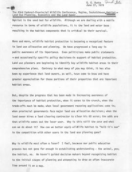
This external hard drive contains back-up files from Gary Runka and Joan Sawicki's computers. The digital files consist of personal, professional, and business records. Includes textual documents (PDF and Word format), spreadsheets (Excel), digital images (JPEG), and email backup files.

Granville Island street railway
2013.6.25.5 · Dossier · 2011-2013
Fait partie de David Davies Railway Collection

File consists of research material regarding Granville Island street railway operations of BC Hydro Railway. Predominantly consists of photocopy reproductions, excerpts from books, and clippings from periodicals. Includes the following works: "The Granville Island Switching Operations of the British Columbia Hydro and Power Authority Railway" by Sochowski and "BCER Granville Island: Extension of Industrial and Interurban Lines within Vancouver City" by Davies.

Dr. D. B. Lazier Record of Confinements
2018.05 · Collection · Sept. 1901 - Jan. 1930

This journal by Dr. Lazier consists of his obstetric notes on pregnancies, childbirths, infant deaths, and maternal deaths during his practice from 1901 through 1918 and 1922 through 1930. Some of the locations and regions covered in the journal include: Prince George/Fort George and the surrounding area, Nakusp, Arrowhead, Beaton, Camborne, Princeton, Fraser Lake, Burns Lake, Grayson (Saskatchewan), Neville (Saskatchewan), Ranfurly (Alberta), Minburn (Alberta), etc. A few pages at the back of the journal consists of a child’s writing in pencil of a “list of made up words” and a list of “German words.”

Sans titre
2013.6.02.6 · Dossier · 1994-2011
Fait partie de David Davies Railway Collection

File consists of maps of the Pacific Great Eastern (PGE) and BC Rail (BCR) trackage in British Columbia, which consist of photocopy reproductions and hand drawn works by Davies. Includes maps of PGE/BCR track in various B.C. cities (Fort St. John, Chetwynd, Dawson Creek, Squamish, 100 Mile House, Lillooet, Fort Nelson, Williams Lake, West Vancouver, Quesnel); maps of PGE/BCR track at various times (1973, 1986); and maps of the Dease Lake extension.

2013.6.03.13 · Dossier · 2008-2012
Fait partie de David Davies Railway Collection

File consists of documents relating to the construction of the Pacific Great Eastern Railway (PGE), which predominantly consist of photocopy reproductions, excerpts from books, and clippings from periodicals. Includes a chronology of the history of PGE, a list of sub-contractors who completed the Squamish sub-division, "PGE/BCR: Dease Lake Extension First 25 Years, 1968 to 1993", and "P.G.E.R. 1914 to 1923: Progressive Dates of Commencement of Passenger Service".

2003.4.3.025 · Dossier · 1987-1989
Fait partie de Kemano Completion Project Dispute Collection

File consists of memoranda from Per Saxvik to Bell-Irving regarding "Fraser River Flow Analysis with Reference to Fish Passage Capacity through the Main Fishways at Hell's Gate". Also includes a "Fraser River Canyon Fish Passage Summary Report (June 1988) Updated October 1989" by Per Saxvik of SEP Engineering.

2006.18.1.12 · Dossier · 2006-2007
Fait partie de Aleza Lake Research Forest Society fonds

File consists of:

  • David Mills, "Aleza Lake Research Forest Historical Internship Summary" (2 Jan. 2007), 26 p. - In print and original digital .doc file
  • David Mills, "Aleza Lake Forest Experiment Station Socio-Economic Time Line 1905-1937" (2007), 68 p. - In print and original digital .doc file
  • ALRFS employment paperwork for David Mills, the ALRFS Natural Resource History Intern
  • Research notes, including a copy of a map of the town of Aleza Lake in the 1920s
Churchill Look-Out Photographs
2006.18.6.01 · Dossier · [196-?]
Fait partie de Aleza Lake Research Forest Society fonds

Photographs are panoramas taken from the Churchill BC Forest Service Lookout, located at latitude 54°04' and longitude 122°16'. The photographs were bound together and include a transparent grid that was intended to be used for locating forest fires.

Personal electronic records
2016.7.1.6 · Dossier · 1994-2006
Fait partie de Dr. Joselito Arocena fonds

File consists of selected personal records from Dr. Joselito Arocena's digital media. Includes 3 floppies and migrated data from hard drives.