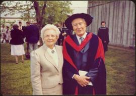
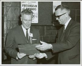
Item is a photograph of Mr. Williston receiving the Man of the Year Award from the Newsmen’s Club of BC for outstanding achievement in public service. The award was presented by Dr. John B. MacDonald, President of UBC on November 7, 1964.
Item is a photograph of Mr. Williston after receiving his honourary degree. Mrs. Williston is pictured with him.
Item consists of transcript and tape summary of interview with local boxer Harold Mann discussing his boxing career.
Sin títuloItem consists of transcript and tape summary of interview with Catholic Bishop Fergus O'Grady on his retirement as Bishop of the local Catholic Diocese of Prince George. Discusses also the Oblate Missionary Order and their history in Northern British Columbia. Also discusses the founding of the Prince George College.
Sin títuloConsists of one bound 1938 Annual from Lord Byng High School in Vancouver.
Item consists of a Certificate of Achievement from the University of British Columbia certifying that Nedra Jane Paul attended the Summer School of the Theatre 5 July to 17 August 1954 and completed the requirements in Stagecrafts.
This photograph album consists of photographs, membership cards and correspondence of Herbert F. Glassey. Subjects identified in this album include: automobiles, landscape vistas, hunting scenes, snowshoeing, dog sledding, provincial government offices and waterscapes. Identified geographic locations include: Nesutlane Trading Post, Atlin, Teslin Lake, Atlin Lake, McKee Creek, Taku Glacier and Otter Creek. The following of Mr. Glassey’s membership cards are also included within this album: “White Pass & Yukon Route, No. 308: Government Agent, Atlin account, 1939-1940”; “White Pass & Yukon Route, No. 283: Government Agent account, 1941-1942”; “Registration Certificate, 1940”; “The Wartime Prices and Trade Board, no.1305, 1942”; “Dominion Bureau of Statistics, no.252”; “The Society of Notaries Public Membership Card, 1956”; and “Prince Rupert Liberal Association, 1953”.
Sin títuloThis bound photo album comprises 122 photographic images featuring the fishing industry, river & landscapes, salmon cannery images (housing, people, workers, boats, machinery) and First Nations Peoples on the Nass & Skeena Rivers and North Pacific Coast. Images also include warships, freighters, automobiles, railway stations and trains, and some photographs of Yokohama, Japan and California ca.1924-25. Includes photographs of the 1924 Special Service Squadron World Cruise in Vancouver. Each photograph is accompanied by a handwritten description glued below or beside the image and each image is glued to the album page at its corners. The verso of front cover has a handwritten name plate:
Photograph believed to have been taken at the Museum of Anthropology in Vancouver, B.C. Unidentified individuals can be seen walking in front of forest in background.
Item is one of nine photographs accompanying a greeting card from Agnes Hauglak, Addie Milewski’s sister, reading: “I though you might want these photos. I had to go and send every one their family things. Thank you for being kind to my sister Addie, Agnes M Hauglak”; see also items 2009.6.1.569 - 2009.6.1.577.
Map depicts British Columbia in its entirety as-well as smaller subsequent maps of Vancouver, Victoria and Vicinity, Prince George, Kamloops, Nelson, and Vancouver Island.
Map depicts annotations marking the major freight-ways: Garnet Ent. Truck Haul from Vancouver to Terrace, Canada Freightways Lyndon Trucking from Vancouver-Edmonton-Alaska Highway, Lindsays Transfer from Terrace to Dease Lake and Telegraph Creek, and the Northland Navigation roll-on and roll-off service. The cities and towns of Vancouver, Prince George, Dawson Creek, Terrace, Kitimat and Whitehorse are noted.
Map depicts the city of Vancouver and its railways.
Photograph depicts the False Creek Trestle bridge open and the Granville Bridge looking east.
Photograph depicts the piers of the south tower on the Lions Gate Bridge in Vancouver, BC
Photograph depicts the Lions Gate Bridge on west side looking south from the shore of North Vancouver, BC
Photograph depicts the Second Narrows railway bridge in Vancouver from the south bank. The bascule does not move.
Photograph depicts the north side lifting tower of the Second Narrows railway bridge in Vancouver, BC
Photograph depicts the Second Narrows Railway Bridge in Vancouver, BCwith the lifting span up.
Photograph depicts the road and rail bridges at Second Narrows, Vancouver B.C. The photograph was taken from Boundary Rd. looking north.
Photograph depicts the rail approach to the Second Narrows Railway Bridge in Vancouver, BCThe shot taken on CPR trackage and from underneath the road bridge on the south bank.
Photograph depicts the Second Narrows Railway Bridge, looking east.
Photograph depicts the road bridge crossing the south section of the north arm of the Fraser River at Fraser St. The view is from the north bank of Lulu Island.
Photograph depicts the Fraser St. road bridge over the north section of the north arm of the Fraser River, looking north from Mitchell Island to Vancouver, BC
Photograph depicts the Cambie St. Bridge in Vancouver, BC, looking southeast and showing the southern fixed span on the bridge.
Photograph depicts a bandstand at English Bay in Vancouver, B.C.
Photograph depicts the building for the Vancouver Supply Company located at 25 Alexander St. in Vancouver, B.C. It is at the center of the old downtown and may have been a former fire hall.
Photograph depicts the former C.P.R. route connecting existing False Creek rail yards and the Burrard shoreline main line. The view is looking southwest from the intersection of Powell St. (in foreground) and Columbia St. (not seen) in Vancouver.
Photograph depicts the Grand Central Hotel at the intersection of Marpole Ave and Hudson St. in south Vancouver. The hotel was built in 1912 by J.J. Graver and run from 1913-1915. It re-opened in 1920 as a home for incurables (veterans). In 1937 it became the provincial infirmary and closed in May 1965.
Photograph depicts a corner building on Chilco and West Georgia St. facing Stanley Park in Vancouver, B.C. The view is looking east across Chilco St.
Photograph depicts the site of a former C.P.R. connection between the mainline into Vancouver and False Creek yards at West Pender St. In Vancouver. The rails are not used but still appear in the street and on the parking lot on the far side. Another parallel set of tracks 30 yards to the east are in daily use.
Photograph depicts East Pender St., looking west towards the Vancouver Sun newspaper office near Abbot St. in Vancouver, B.C.
Photograph depicts Alberni St. in the west end of Vancouver. It is directly opposite the Vehicle Testing Station, in the 1700 block. The view in the photo is looking east.
Photograph depicts a courthouse in Vancouver, B.C. surrounded by a fence with paintings.
Photograph depicts a painting on a fence outside a courthouse on Howe St. in Vancouver, B.C. The painting shows the natural grandeur of B.C. partially blocked out by a super motel with a bewildered moose forced to become an ornamental fountain. The whole forecourt is being bulldozed to make way for the Centennial fountain.
Photograph depicts house at #1053 Beach Ave. in Vancouver, B.C. Dan Davies was a resident at one time.
Photograph depicts Beach Ave. in Vancouver, with the photo taken near the swimming pool and looking west. Photo was taken after a storm.
Photograph depicts home at #1053 Beach Ave., which is now fully demolished.
Photograph depicts a general view of Coal Harbour in Vancouver, looking southeast and south with Marine Building (downtown) on extreme left and Stanley Park (unseen) at extreme right.
Photograph depicts the general view of the waterfront buildings between Burrard and Thurlow St., in Vancouver Harbour looking northwest from Burrard St. The Immigration Building is on the left and the "Princess of Vancouver" (C.P.R.) is in the middle distance.
Photograph depicts the north bank of False Creek in Vancouver, B.C. The photograph was taken from the Cambie Bridge, with a view looking west.
Photograph depicts former tram tracks, looking north from the intersection at Campbell Ave and east Georgia St. in Vancouver, BC
Photograph depicts a West Coast Railway Association locomotive and car at a C.N.R. station in Vancouver. The trackage actually belongs to a demolished Great Northern Railway Station.
Photograph depicts a train at the Great Northern Railway Station in Vancouver, B.C.
Photograph depicts the extreme west end of C.P.R. trackage at Coal Harbour, looking east towards the yards and downtown after a snowfall.
Photograph depicts a C.P.R. wrecking train unit at Vancouver station.
Photograph depicts the C.P.R. yards in Vancouver, just west of railway station in the downtown area. The view is looking east from Burrard St.
Photograph depicts the C.P.R. yards just west of downtown passenger station and in front of Pier B, owned by the C.P.R. The view is looking northwest from Burrard St.
Photograph depicts a B.C. Electric Railway locomotive #902 and boxcar entering the Kitsilano yards and crossing 2nd Ave., near Fir St. in Vancouver.
Photograph depicts the B.C. Electric Railway trackage at Kerrisdale in Vancouver. The photo was taken from 49th Ave. and West Boulevard, looking north. The second track used to lie to the right of the existing one.
Photograph depicts the former B.C. Electric Railway spur running westwards along Bridgeport Rd., leading from the former main trackage. It was not in use for many years and was lifted in 1965, except for road crossings. The photo is taken from the intersection with Sexsmith Rd., looking east. The former main trackage is sited about 300 yards in the background and at right angles to the track in the foreground.