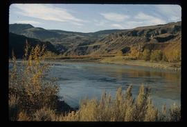
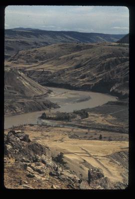
Previsualizar a impressão Fechar

Mostrar 144 resultados

Archival description
Moran Canyon
2012.13.1.53.48 · Item · July 1982
Parte de J. Kent Sedgwick fonds

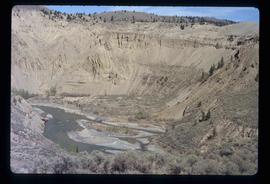
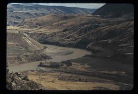
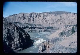
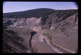
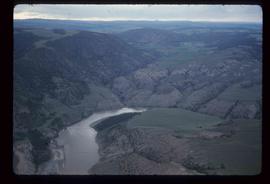
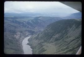
Image depicts a view of Moran Canyon in the Lillooet area. The Fraser River is visible on the left.

Lillooet - Bridges
2012.13.1.53.44 · Item · July 1982
Parte de J. Kent Sedgwick fonds

Image depicts two bridges over the Fraser River, located somewhere in Lillooet, B.C.

Lillooet - Bridges
2012.13.1.53.45 · Item · July 1982
Parte de J. Kent Sedgwick fonds

Image depicts two bridges over the Fraser River, located somewhere in Lillooet, B.C.

Lillooet - Bridges
2012.13.1.53.46 · Item · July 1982
Parte de J. Kent Sedgwick fonds

Image depicts two bridges over the Fraser River, located somewhere in Lillooet, B.C.

Moran Canyon
2012.13.1.53.50 · Item · July 1982
Parte de J. Kent Sedgwick fonds

Image depicts the Moran Canyon; the Fraser River is visible near the bottom.

Fraser River - Bridge
2012.13.1.52.44 · Item · [1980?]
Parte de J. Kent Sedgwick fonds

Image depicts a bridge over the Fraser River in the Upper Fraser Canyon; possibly near Gang Ranch.

Gang Ranch - Fraser River
2012.13.1.52.34 · Item · [1980?]
Parte de J. Kent Sedgwick fonds

Image depicts the Fraser River, and a sign pointing towards Gang Ranch with an unknown individual hugging it, in the Upper Fraser Canyon.

Upper Fraser Canyon
2012.13.1.52.30 · Item · 1980
Parte de J. Kent Sedgwick fonds

Image depicts a view of the upper Fraser Canyon. The Fraser River is visible on the left side of the image.

Upper Fraser Canyon
2012.13.1.52.31 · Item · 1980
Parte de J. Kent Sedgwick fonds

Image depicts a view of the upper Fraser Canyon. The Fraser River is visible on the left side of the image.

Fraser Valley
2012.13.1.50.066 · Item · 1978
Parte de J. Kent Sedgwick fonds

Image depicts the Fraser Valley, looking north, possibly from Marguerite, B.C.

Fraser River
2012.13.1.50.065 · Item · 1978
Parte de J. Kent Sedgwick fonds

Image depicts the Fraser River, looking south from Marguerite, B.C.

Farm
2012.13.1.50.067 · Item · 1978
Parte de J. Kent Sedgwick fonds

Image depicts a farm on the west side of the Fraser, south of Quesnel, B.C.

Rock Formations
2012.13.1.65.52 · Item · [1976?]
Parte de J. Kent Sedgwick fonds

Image depicts ridge-like rock formations at an uncertain location, though possibly somewhere near the Fraser River.

Fraser River?
2012.13.1.65.46 · Item · May 1976
Parte de J. Kent Sedgwick fonds

Image depicts what is possibly a section of the Fraser River.

Moran Canyon
2012.13.1.53.23 · Item · Mar. 1975
Parte de J. Kent Sedgwick fonds

Image depicts the Fraser River running through the Moran Canyon near Lillooet, B.C.

Slump or Mining
2012.13.1.65.34 · Item · June 1975
Parte de J. Kent Sedgwick fonds

Image depicts an aerial view of a section of land, likely near the Fraser River, that is possibly either a slump or part of a mining operation. The slide is labelled "slump or mining."

Moran Canyon
2012.13.1.53.19 · Item · Mar. 1975
Parte de J. Kent Sedgwick fonds

Image depicts the Fraser River running through the Moran Canyon near Lillooet, B.C.

Moran Canyon
2012.13.1.53.24 · Item · Mar. 1975
Parte de J. Kent Sedgwick fonds

Image depicts the Fraser River running through the Moran Canyon near Lillooet, B.C.