Showing 81 results

Archival description
2011.12.25 · Item · [ca. September 1950- June 1951]
Part of Giscome, BC Historical Photograph collection

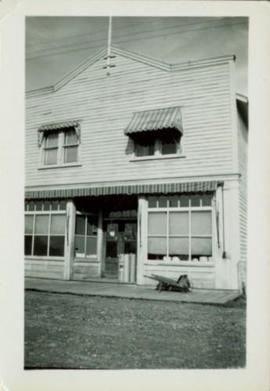
Photograph of the front of Brown's General Store. Handwritten annotation in pen on verso reads: “Brown’s General Store. The wheelbarrow is for bringing the groceries and mail over from the train. Also if you buy a great quantity of things you wheel it home and then bring back the barrow (Taken on Sunday).”

Giscome
2012.13.1.87.175 · Item · [between 1975 and 1995]
Part of J. Kent Sedgwick fonds

Image depicts the Giscome, B.C. town site with the Giscome railway station and the Giscome store in the center surrounded by vehicles. Map coordinates 54°04'18.5"N 122°21'57.7"W

Giscome - Church
2012.13.1.87.099 · Item · [between 1975 and 1995]
Part of J. Kent Sedgwick fonds

Image depicts a church in Giscome, B.C. Map coordinates 54°04'16.2"N 122°21'54.3"W

Giscome - Eaglet Lake
2012.13.1.87.090 · Item · [between 1980 and 2000]
Part of J. Kent Sedgwick fonds

Image depicts mill site and dock in Giscome, B.C. with Eaglet Lake in the background covered in ice. There is a large crowd of people gathered near the dock. Map coordinates 54°04'34.9"N 122°21'50.0"W

Giscome - Power Poles
2012.13.1.87.098 · Item · [between 1975 and 1995]
Part of J. Kent Sedgwick fonds

Image depicts the remains of a street of houses in Giscome, B.C. The quarry is slightly visible in the background. Map coordinates 54°04'20.9"N 122°21'53.1"W

2012.13.1.87.086 · Item · [between 1980 and 2000]
Part of J. Kent Sedgwick fonds

Image depicts the Giscome mill site in Giscome, B.C. The bunkhouse is the large building with many windows. A train and railroad tracks are in the foreground. Map coordinates 54°04'17.6"N 122°22'06.1"W

Giscome Bunkhouse
2012.13.1.87.158 · Item · [between 1975 and 1995]
Part of J. Kent Sedgwick fonds

Image depicts the Giscome bunkhouse in Giscome, B.C. Map coordinates 54°04'17.6"N 122°22'06.1"W

Giscome CN Station
2012.13.1.87.161 · Item · [between 1975 and 1995]
Part of J. Kent Sedgwick fonds

Image depicts the old CN station in Giscome, B.C. Map coordinates 54°04'20.7"N 122°22'01.1"W

Giscome Community Hall
2012.13.1.87.160 · Item · [between 1975 and 1995]
Part of J. Kent Sedgwick fonds

Image depicts the Giscome Community Hall in Giscome, B.C. Map coordinates 54°04'18.5"N 122°21'57.7"W

Giscome Dairy Farm
2012.13.1.87.083 · Item · [between 1975 and 1995]
Part of J. Kent Sedgwick fonds

Image depicts a large, old and collapsing barn, as well as a nearby house of the dairy farm in Giscome, B.C. Map coordinates 54°03'53.3"N 122°21'22.6"W

Giscome Dairy Farm
2012.13.1.87.141 · Item · [between 1975 and 1995]
Part of J. Kent Sedgwick fonds

Image depicts the dairy farm in Giscome, B.C. Map coordinates 54°03'53.3"N 122°21'22.6"W

Giscome Dock and Wood Scraps
2012.13.1.87.166 · Item · [between 1975 and 1995]
Part of J. Kent Sedgwick fonds

Image depicts a dock at an inlet of Eaglet Lake in Giscome, B.C. There are numerous logs and other pieces of wood scattered in the foreground. Map coordinates 54°04'34.9"N 122°21'50.0"W

2012.13.1.89.084 · Item · [1980?]
Part of J. Kent Sedgwick fonds

Image depicts Giscome with the school on the left, the remnants of the town site in the middle and the church on the right. Map coordinates 54°03'58.2"N 122°22'04.8"W

Giscome Houses
2012.13.1.87.164 · Item · [between 1975 and 1995]
Part of J. Kent Sedgwick fonds

Image depicts a row of houses at an uncertain location, possibly in Giscome, B.C.

Giscome Landscape
2012.13.1.87.071 · Item · [between 1975 and 1995]
Part of J. Kent Sedgwick fonds

Image depicts an open area with Eaglet Lake in the background. It depicts the previous site of the mill at Giscome, B.C. Map coordinates 54°04'19.7"N 122°22'04.7"W

Giscome Parking Lot
2012.13.1.87.174 · Item · [between 1975 and 1995]
Part of J. Kent Sedgwick fonds

Image depicts a parking lot full of vehicles with the Giscome store in the background. Map coordinates 54°04'18.5"N 122°21'57.7"W

Giscome Quarry
2012.13.1.87.074 · Item · [between 1975 and 1995]
Part of J. Kent Sedgwick fonds

Image depicts what is possibly the quarry located at Eaglet Lake in Giscome, B.C.

Giscome Sawmill
2012.13.1.87.167 · Item · [between 1975 and 1995]
Part of J. Kent Sedgwick fonds

Image depicts the mill site at Giscome, B.C. Map coordinates 54°04'19.7"N 122°22'04.7"W

Giscome Sawmill
2012.13.1.87.171 · Item · [between 1975 and 1995]
Part of J. Kent Sedgwick fonds

Image depicts the mill site at Giscome, B.C. A sign in the foreground reads "Maynard's Industrial Auctioneers." Map coordinates 54°04'19.7"N 122°22'04.7"W

Giscome Sawmill
2012.13.1.87.168 · Item · [between 1975 and 1995]
Part of J. Kent Sedgwick fonds

Image depicts the mill site at Giscome, B.C. Map coordinates 54°04'19.7"N 122°22'04.7"W

Giscome Sawmill
2012.13.1.87.170 · Item · [between 1975 and 1995]
Part of J. Kent Sedgwick fonds

Image depicts the mill site at Giscome, B.C. Map coordinates 54°04'19.7"N 122°22'04.7"W

Giscome Sawmill
2012.13.1.87.176 · Item · [between 1975 and 1995]
Part of J. Kent Sedgwick fonds

Image depicts the Giscome, B.C. mill site looking west. Map coordinates 54°04'18.5"N 122°21'57.7"W

Giscome Sawmill
2012.13.1.87.169 · Item · [between 1975 and 1995]
Part of J. Kent Sedgwick fonds

Image depicts the mill site at Giscome and its beehive burner. Map coordinates 54°04'19.7"N 122°22'04.7"W

Giscome School - After
2012.13.1.87.085 · Item · [between 1975 and 1995]
Part of J. Kent Sedgwick fonds

Image depicts the Giscome mill site in Giscome, B.C. The bunkhouse is no longer there and the school is in the foreground on the right. Map coordinates 54°04'04.8"N 122°22'04.7"W

Giscome School - Before
2012.13.1.87.084 · Item · [between 1980 and 2000?]
Part of J. Kent Sedgwick fonds

Image depicts the Giscome mill site in Giscome, B.C. The bunkhouse is in the background on the left and the school is in the foreground on the right. Map coordinates 54°04'04.8"N 122°22'04.7"W

2011.12.09 · Item · [ca. September 1950- June 1951]
Part of Giscome, BC Historical Photograph collection

Street view featuring a dirt road leading directly to Giscome School, a three room institution. On the right the steeple of the Catholic church is visible, beside which was Neff’s (sp?) corner store. Handwritten annotation in pen on verso reads: “Looking up our street. The school is at the end.”