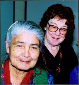
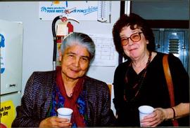
Showing 62 results

Archival description
2008.3.1.19.3 · Item · March 1992
Part of Bridget Moran fonds

Photograph depicts Bridget Moran standing behind Mary John in unknown room. Unidentified woman semi-visible on far right (see item 2008.3.1.19.2). Accompanying photo caption: "Caribou College, Quesnel, March /92".

Cottonwood House
2012.13.1.126.49 · Item · [1990?]
Part of J. Kent Sedgwick fonds

Image depicts the Cottonwood House Historic Site along Barkerville Highway, east of Quesnel, B.C. A sign posted by the fence reads: "For over half a century the Boyd family operated this haven for man and beast. Here weary travellers found lodging, food, and drink. Here fresh horses were hitched to stage-coaches and miners bought supplies. This historic road-house, built in 1864, stood as an oasis of civilization on the frontier of a rich new land."

Dairy Farm - Interior
2012.13.1.50.073 · Item · [1978?]
Part of J. Kent Sedgwick fonds

Image depicts numerous pieces of machinery in the interior of a building at a dairy farm, located somewhere near Quesnel, B.C. Several unknown individuals are present.

Farm
2012.13.1.50.067 · Item · 1978
Part of J. Kent Sedgwick fonds

Image depicts a farm on the west side of the Fraser, south of Quesnel, B.C.

PGE Quesnel
2013.6.36.1.045.30 · Item · 1966
Part of David Davies Railway Collection

Photograph location is unknown, but Davies stated it to be possibly somewhere north of Quesnel. A bridge is visible.

PGE Quesnel
2013.6.36.1.045.39 · Item · [July 1966]
Part of David Davies Railway Collection

Photograph depicts a down freight of 75 cars passing under the Quesnel to Barkerville road about 4 miles out of Quesnel.

Gordon Wyness Album
2020.05 · Collection · 1936

In 1936, Gordon Young Wyness was employed by Philip M. Monckton, a B.C. Land Surveyor. Between June 5 and October 8, Wyness joined Monckton and a group of others on a land survey expedition in northwestern BC. The survey crew travelled to various locations in the area including Telkwa, Hazelton, Burns Lake, Francoise Lake, Vanderhoof, Prince George, Quesnel, Lytton, and Hope. Wyness documented their journey in this photograph album. Based on the photographs, it appears that the crew led by Philip Monckton consisted of Jack Lee and Gordon Wyness; Mrs. Lavender Monckton (nee O'Hara) also accompanied the group.

In addition to the 50 photographs included in the album, this collection also includes five additional unique photographs that accompanied the album.

Wyness, Gordon Young
2020.05.44 · Item · 1936
Part of Gordon Wyness Album

Photograph depicts Gordon Wyness sitting on a historic boat, which he described as built ca. 1860 and could carry "7 Indians" and 5000 lbs of freight up the river. Located nearby is a telegraph cairn erected to commemorate the Collins Overland Telegraph lines that began in Quesnel in 1865. Until 1907, Quesnel was the terminus for the telegraph line. Behind Wyness is a replica of a Cornish water wheel that was originally located at Williams Creek in Barkerville. This location is now called Ceal Tingley Memorial Park-Heritage Corner and is located along Front Street in Quesnel, near the Fraser River Bridge. The cairn and water wheel still stand in this location, however the boat was removed around 1941.

According to additional information from Quesnel & District Museum & Archives, Wyness may have been provided with inaccurate information about the canoe depicted. The canoe believed to have been located at that spot was actually created in 1905 to pack out the Grand Trunk Preliminary Survey Team, which was led by J.M. Rolston.

2007.17.1.4 · Item · 1935
Part of James Joseph Claxton Photograph Collection

Photograph depicts a snow-covered forest clearing with six structures and a truck. Buildings have been numbered 1-8 with pen. Original handwritten annotations on verso of photograph are signed by Tom Marsh. Photograph is taped to paper. Typed annotation on recto of paper reads: “1. Bridge over creek. 2. Blacksmith shop. 3. Powerhouse. 4. Headframe over 200’ shaft. 5. Office 6. Water tanks from powerhouse. 7. Bunkhouse. 8. Truck. 9. Cookhouse behind #6 cannot be seen. We were always able to find the cookhouse even though hidden in this picture. Taken about 1935 by Russell Ross, supt. Quesnel Quarts Mine. Tom Marsh, Box 156, Squamish B. C.”

Front Street, Quesnel, BC
2011.3.1.17 · Item · ca. 1930
Part of North Coast & Central BC Postcard Collection

Street view photograph taken at the intersection of Front Street and Carson Avenue. Several men are gathered at Cowan's Hardware store on the corner. Also visible in this photograph is the Cariboo Hotel (visible furthest to the left), and the British American Hotel which is partially visible behind the J.A. Fraser store. Printed annotation on recto reads: "On Front Street, Quesnel, B.C."

Carson Avenue, Quesnel, BC
2011.3.1.16 · Item · ca. 1930
Part of North Coast & Central BC Postcard Collection

Street view photograph looking down Carson Avenue at the Front St. intersection in Quesnel, BC. Several identified businesses line the gravel avenue on the right; however Cowan's Hardware store is visible at the intersection on the left. Printed annotation on recto reads: "Carson Ave., Quesnel, B.C. 1930 Looking East."

S.S. Charlotte, Quesnel BC
2011.3.4.02 · Item · [ca. 1901-1915]
Part of North Coast & Central BC Postcard Collection

Stern wheeler in river. Printed annotation on recto reads: “S.S. “Charlotte,” Quesnel. B.C.” Handwritten message on verso is addressed to “Mr. O. Winter 1016 V Park St. Victoria B.C.” The dates on the canceled 1 cent Canadian stamp on verso are not readable.

Holts Ranch
2014.10.1.151 · Item · 1911
Part of Arthur Holland Land Surveying Collection

Photograph depicts a cluster of log buildings with fences and corrals. A field in the foreground, trees and low hills in the distance. On the road from Quesnell to Fraser Lake 1911.