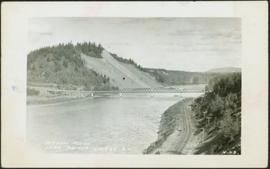
Item is a photograph of Prince George taken from the air, looking east with the Cameron Street Bridge in the foreground.
Photograph depicts Moran wearing regalia, standing to right of family members in the Agora courtyard at the University of Northern British Columbia in Prince George, B.C. Sons Mike (wearing black) and Pat stand on left, and Paul Ramsey stands in center. Unidentified individuals stand near Winter Garden in background. Photo taken on the day Moran received an Honourary Law Degree.
Back, left to right: Ellen (nee Taylor) and husband Percy Garland, Joan Graves (daughter of Lucy Taylor), Dick Baxter (son of Violet), Violet (nee Taylor) Baxter. Front, left to right: [unknown], Margret Baxter (wife of Alan Baxter), Judy Taylor (daughter of Arthur Taylor), Edna Roth (daughter of Violet).
Photograph taken on Ross Crescent, Prince George, at the home of Violet Baxter. Car and trees in background.
Photograph features the hotel on George Street, Prince George BC. Handwritten annotation on verso of photograph reads: "Xmas [1948?]", on recto: "From Mr. & Mrs. Fask Douglas." Poem on verso reads: "May Christmas Joy And all its cheer Be yours throughout A good New Year".
Photograph depicts bridge over Nechako River. Sloped cutbanks on opposite shore in background. Railroad tracks can be seen on town shore in right foreground. Handwritten annotation on verso of photograph: "NECHAKO RIVER NEAR PRINCE GEORGE B.C. N.H.D."
Handwritten annotation on verso of photograph: "PRINCE GEORGE B.C. FARMERS TAKING DELIVERY OF CATERPILLAR TRACTORS." Bob sits on first tractor in line of three. Fifteen men stand in a line against street buildings. "THE SALVATION ARMY" building stands in background on right. This photograph was taken at the corner of 4th and George St.
Photograph depicts man believed to be Bob Baxter on bulldozer by large framework structure in snow. House stands in background as well as a truck with "CITY OF PRINCE GEORGE" visible on its passenger door. Handwritten annotation on recto of photograph: "Civic centre 1948."
Postcard featuring a photograph of a photograph of the arrival of the first stage coach at the Hotel Northern in South Fort George, BC on 19 October 1911. Handwritten annotation on recto of photograph reads: “Arrival of first stage at So. Ft. George B.C. Oct. 19, 1911. 28” Printed caption on the recto of the postcard reads: “First stage coach Prince George, B.C.” Handwritten annotation in pen on verso of postcard reads: “Mrs. C. Morris, Box 925, Penticton, BC. Thurs. 6pm, Dear Mother. Arr. Safely, good trip (bad pen!) Lovely weather. Hope all are well. Bia (?) Mary & Ed”
Postcard image depicts streetview looking west along 3rd Ave in Prince George, B.C. Storefronts and period automobiles are visible. Handwritten annotation on photographic negative, now visible along bottom of print image reads: "3rd Ave, Prince George B.C. Looking West. HND 41".
Photograph taken in front of the 'icebergs' at the University of Northern British Columbia in Prince George, B.C. Campagnolo stands in middle row, third from right.
Card accompanying photograph reads: “UNBC’s 10th Anniversary, 08/17/04, With the compliments of Charles J. Jago, President and Vice-Chancellor”.
Photograph depicts Hotel Fort George with people, cars and power pole in foreground. Handwritten annotation on verso reads: “Hotel Fort George - 1913”.
Street scene showing people, dog, team of horses & wagon. Signage reads: “Beds; Mecca Café; Hardware.” Printed annotation on recto reads: “Hamilton Avenue, South Fort George, B. C. No. 110.” Verso displays cancelled 1 cent Canadian Postage Stamp and handwritten message in ink is addressed to Mr. Eathan Villard Burt Mish, U.S.A.
Photograph of Prince George Hotel with several early model cars and a few people. Printed annotation on recto reads: “Hotel Prince George, Prince George, B. C.”
Overhead view of commercial buildings in downtown Prince George. Printed annotation on recto reads: "Prince George, B.C."
Photograph taken from the intersection of 3rd Avenue and an unidentified street. Visible businesses include "Ben Baird The Smart Shop" and "C.N.R. Cafe." Printed annotation on recto reads: "3rd Ave. PR. George, B.C."
Aerial view of Prince George and surrounding forested area. Printed annotation on recto reads: "Prince George, B.C."
Wide angle photograph of a forested area with Prince George in the distance. Printed annotation on recto reads: "Prince George, B.C. 1924."
Photograph depicts two women with flowers and three men standing on grass and boardwalk in foreground, large building in background.
Handwritten annotation on verso: “Government Agency at S. Fort George 1922."
Photograph depicts hotel on corner of street, crowd and cars in foreground.
Handwritten annotation on verso “Albert Johnson’s 'Northern Hotel' South Fort George 1914".
Photograph depicts two men standing in front of very small wood building with tarp-covered roof. Chair and paper documents can be seen in front of building, trees and rough cleared land in background.
Handwritten annotation on verso: “The first newspaper office, South Fort George 1910."
Photo depicts a street perspective of George St., in Prince George, BC, ca. 1950. Annotation recto reads: "George St. Prince George BC Photo by J Wrathall." Handwritten annotation in pen on verso of postcard reads: “This is the Hastings Street of Prince George. This & 3rd Streets are the main thoroughfares.”
Image depicts Highway 97 at 15th Ave. looking north. Map coordinates 53°54'42.1"N 122°46'53.1"W
Image depicts mobile homes for sale on Cowart Road looking northeast with Simon Fraser Bridge in background. Map coordinates 53°52'39.3"N 122°46'13.1"W
Image depicts Parkwood Place taken from Connaught Hill looking west with the hospital in the background. Map coordinates 53°54'39.9"N 122°45'02.5"W
Image depicts downtown Prince George looking northwest across Dominion Street. Map coordinates 53°54'48.7"N 122°44'45.6"W
Image depicts a view of Prince George from City Hall looking northeast with the pulp mills in the background. Map coordinates 53°54'46.3"N 122°44'41.9"W
Image depicts a view of Prince George from Cranbrook Hill looking southeast. Map coordinates 53°54'51.5"N 122°49'05.2"W
Image depicts downtown Prince George taken from City Hall looking northwest. Map coordinates 53°54'46.2"N 122°44'43.9"W
Image depicts a Beehive Burner along the Nechako on River Road. Map coordinates 53°55'34.1"N 122°44'58.0"W.
Image depicts Parkside Intermediate Care Home on Ospika Boulevard in Prince George. Map coordinates 53°55'02.6"N 122°47'41.6"W
Image depicts 4th Ave at Brunswick St. and the following businesses: Hart Drugs, The Yarn Barn, and Saveco. Map coordinates 53°54'59.9"N 122°44'52.9"W
Image depicts 4th Ave at Quebec St, showing the following businesses: The Yarn Barn, Golden Chalice Jewellers, Dandy Lines, Ultrasport, and Saveco. Map coordinates 53°54'58.6"N 122°44'47.5"W
Image depicts the Northwood pulpmill in Prince George B.C.
Image depicts a number of trains in the CNR train yard taken from River Road in Prince George, B.C. Map coordinates 53°54'51.5"N 122°43'29.6"W
Image depicts a view of Blackburn Schools, possibly taken from Tabor Mountain.
Image depicts Prince George, possibly with the Northwood Pulpmill in the background.
Image depicts downtown Prince George taken from across the Nechako River looking south. Map coordinates 53°56'00.0"N 122°44'29.7"W
Image depicts Prince George Sawmill taken from across the Nechako River looking southwest. Map coordinates 53°56'00.0"N 122°44'29.7"W
Image depicts 3rd Ave in Prince George, B.C. Map coordinates 53°55'01.9"N 122°44'48.7"W
Image depicts a section of Highway 97 looking south. Map coordinates 53°55'10.3"N 122°46'54.9"W
Image depicts an aerial view of a Prince George residential section between Highway 97, Carney Street and 10th Ave looking north. Map coordinates 53°54'54.0"N 122°46'00.4"W
Image depicts the Nechako Subdivision in Prince George, B.C.
Image depicts downtown Prince George, B.C.
Image depicts the Courthouse in Prince George, B.C.
Image depicts the Ramada Hotel in Prince George, B.C.
Image depicts Prince George from University Way, with the P.G.I. Pulp Mill in the distance.
Image depicts the Carter Industrial Area in Prince George, B.C.
Image depicts Glenview Drive near the Hart Highway in Prince George, B.C.