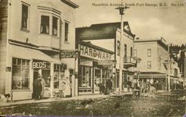
Showing 287 results

Archival description
129 results with digital objects Show results with digital objects
2011.3.2.06 · Stuk · [ca. 1910]
Part of North Coast & Central BC Postcard Collection

Photo of buildings behind street, fenced on either side. Man and horse can be seen on street. Printed annotation on verso reads: “The Government buildings Fort George B. C.” Handwritten annotation on recto reads: “This is the place I receive my patent from next June.”

2011.3.2.10 · Stuk · [ca. 1910]
Part of North Coast & Central BC Postcard Collection

Street scene showing people, dog, team of horses & wagon. Signage reads: “Beds; Mecca Café; Hardware.” Printed annotation on recto reads: “Hamilton Avenue, South Fort George, B. C. No. 110.” Verso displays cancelled 1 cent Canadian Postage Stamp and handwritten message in ink is addressed to Mr. Eathan Villard Burt Mish, U.S.A.

2011.3.2.09 · Stuk · 1913
Part of North Coast & Central BC Postcard Collection

Printed annotation on recto reads: “Central Avenue Fort George B.C. Copyright Canada June 25th 1913”. Handwritten annotation in ink on recto reads: “Hotel Fort George; Pool room; Men’s furnishing; General store; Bank Vancouver; Telephone office; Temperance House; Trust-company; Grand stand & fair grounds; Hospital; Ware house and general store.” Cancelled 1 cent Canadian stamp on verso is dated: "Fort George BC Jul 14 13". Handwritten message in ink on verso is addressed to Mr. Chas H Wilson 94 Gould St Toronto: "Fort George. B.C> Box 65, July 13/ 13. Dear Father, This is a 'bird's eye view' of our main street - ha! ha! some class alright. We live right behind the bakery lunch room on the right hand side of the picture, on 1st avenue, some people eh? Will be moving to Cassiar Ave soon. How are all the folks. Mae is writing. Peace. M."

2011.3.2.05 · Stuk · 1913
Part of North Coast & Central BC Postcard Collection

Lofty view of South Fort George, river and treed hills in the background. Printed annotation on verso reads: “South Fort George - 1913.” Handwritten message on recto is addressed to “Ethel M. Heurris Norton Maps Bristol County" reads: "11-1-13 an excellent view of south Fort George taken recently. Power Station at cross near water. This does not give all the south residence view. Population approx 1500”.

Street in Prince George, BC
2011.3.2.14 · Stuk · [ca. 1920]
Part of North Coast & Central BC Postcard Collection

Street scene in Prince George B.C. Several Union Jack flags are visible and there is a celebration banner at the end of the street. Long shadows in photo indicate summer (perhaps Dominion Day?). River in foreground, railroad and city in mid ground and hill in background. Printed annotation on recto reads: “Prince George. B.C.”

2011.3.2.13 · Stuk · 1921
Part of North Coast & Central BC Postcard Collection

Boardwalk in foreground, buildings and roads in mid ground, cut banks in background. Printed annotation on recto reads: “Prince George. B.C. 1921 by Moore”. Handwritten annotation in ink on verso reads: “The Netchaco river is between the mountain and the city and the C.N.R. runs along the river bank nearest the city. This picture is taken looking north.”

2011.3.2.17 · Stuk · 1921
Part of North Coast & Central BC Postcard Collection

Photograph of George Street in Prince George B.C. Cars, people, and signage are visible. Printed annotation on recto reads: “George St. Prince George B.C. 1921 R7 by Moore” There is an “X” in ink over the fire hall. Handwritten annotation in ink on verso reads: “This view is also looking north and where I have put the X is the one and only fire hall and you can see the fire engine in the street. This is the main street.”

2011.3.2.20 · Stuk · [ca. 1910-1924]
Part of North Coast & Central BC Postcard Collection

Street view photograph of a commercial section in downtown Prince George with several "Campbell's" delivery carts parked along the road. Visible establishments include "Campbell's All Cash Store" and "Club Cafe." Handwritten annotation in blue ballpoint pen on recto reads: "Howdy from Prince George! Going easy with all these kids- good to see Kathee. Snow here. Have fun at the sports show & don't over do it. Thinking of you guys, love Judy and Vic. P.S. Can't wait to go home to somewhere peaceful and quiet. 2-27-83." Postcard is addressed to: "Mr. & Mrs. Hauffer 8429-221 PL. Sn. Edmonds, WA. U.S. 98020." Verso is affixed with four Canadian 8-cent stamps.

2010.13.02 · Stuk · 1927
Part of Prince George Historical Photograph Collection

Photograph depicts young girls dressed in white, walking in front of crowd. One girl holding bouquet wears a long train carried by smaller girls, and is escorted by older man wearing suit. Buildings and decorations can be seen in background.

Handwritten annotation on verso: “The May Queen, Maude Renwich attendants and Mayor Patterson".

2009.5.2.326 · Stuk · May 1938
Part of Taylor-Baxter Family Photograph Collection

Banquet was held for Visiting Officers and Delegates to the B.P.O.E. Provincial Convention in Prince George, B.C. May 25-27, 1938. The banquet was held in the Elks’ Hall on Thursday May 26, 1938. Menu features food courses, toast list and dance programme.

Geographic Features
2006.20.11 · Bestanddeel · [ca. 1890 - 1940]
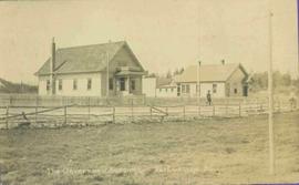
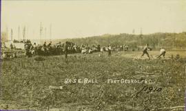
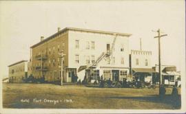
Part of Northern BC Archives Historical Photograph Collection

Photographs within this file document natural and artificial features across the landscape of Northern British Columbia. This landscape also includes the physical, built, urban and industrial landscapes; topography; site plans; boundaries, districts, reserves, parks, sanctuaries, towns, villages and cities, etc.

2010.13 · Collectie · 1910 - [ca. 1950]

Collection contains photographs depicting community life in Prince George, B.C. Images depict holiday events, sports teams, government buildings, businesses (hotels, banks, retail, newspaper office), riverboats, railroad construction, fishing, a cemetery, street scenes, aerials, and landscapes. Also includes photos taken outside of the Prince George vicinity including Prairie Creek, Thomas Creek and Barkerville, B.C.

2011.12 · Collectie · September 1950 - June 1951

This photograph collection consists of 53 photographs featuring primarily Giscome with a few of Prince George. Subjects include the Eagle Lake Sawmill, Eagle Lake, Giscome townsite (including specific buildings and general road perspectives), Giscome School, Division II class photos (1950-51), and the Giscome School teacherage.

2013.04.01 · Bestanddeel · 1958-1961
Part of Howard Foot collection

This scrapbook, entitled "My Two Year Term on the Teen Town Council", was created by Howard Foot to document his involvement in the Prince George Teen Town Council. Howard Foot was the elected "mayor" of the Prince George Teen Town Council for the 1958-1959 term. The British Columbia centennial year was 1958; Teen Town was involved in centennial event planning. The scrapbook includes newspaper clippings from the Prince George Citizen relating to Prince George Teen Town events and the Teen Town Council. These clippings include mention of other Teen Town Council members, including Brian Fawcett who later became a nationally-recognized Canadian writer.

Original photographic prints and reproduced photographs relating to Prince George Teen Town are pasted in and interleaved into the scrapbook. Also interleaved into the scrapbook is a 26 February 1959 issue of the Prince George Echo newspaper. The newspaper issue has a feature article about a Prince George custom car show organized by Howard Foot.

Zonder titel
2002.12.30 · Stuk · c.1970s
Part of Bob Harkins fonds

Item consists of transcript and tape summary of recorded interview with Gordon Wood, pharmacist, businessman and sports enthusiast who lived in Prince George c.1920s-c.1970s. He discusses various events that impacted Prince George including the Great Depression of the 1930s and set up of relief camps; the set up of army camps during World War II. He also discusses local politicians, his drugstore business and community members.

Zonder titel
Highway 97
2012.13.1.3.021 · Stuk · Oct. 1975
Part of J. Kent Sedgwick fonds

Image depicts Highway 97 at 15th Ave. looking north. Map coordinates 53°54'36.0"N 122°46'55.5"W

Highway 97
2012.13.1.3.022 · Stuk · Oct. 1975
Part of J. Kent Sedgwick fonds

Image depicts Highway 97 at 15th Ave. looking north. Map coordinates 53°54'42.1"N 122°46'53.1"W