2023.2.2.14
·
Subseries
·
2022-2024
Part of Dr. Paul Sanborn fonds
1046 results with digital objects
Show results with digital objects
2023.2.2
·
Series
·
1960-2024
Part of Dr. Paul Sanborn fonds
Series consists of records created and collected in relation to research projects Dr. Paul Sanborn was engaged in, often with other colleagues, during his employment with the BC Ministry of Forests and/or the University of Northern British Columbia. These archival research records are predominantly unpublished documents, reports, data, and photographs. Some of Sanborn's research projects did not result in a formal scientific publication. In other instances, some of Sanborn's research projects resulted in only a portion of the collected data utilized for a formal publication.
Sanborn compiled details about each research project and its associated records in a summary note. Each of these notes is provided in PDF format along with its research project series. These notes serve as an essential guide for researchers who wish to interpret, utilize, and repurpose Sanborn's data for other future research projects.
2023.2
·
Fonds
·
1960-2024
Fonds consists of the research records of Dr. Paul Sanborn, a University of Northern British Columbia faculty member in the Department of Ecosystem Science and Management.
Sanborn, Paul Thomas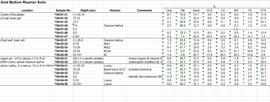
2023.2.2.3.2
·
Item
·
2004, 2023
Part of Dr. Paul Sanborn fonds
Data set consists of lab data for sites Y04-01 to Y04-04. Original data set created in 2004; an update was provided in March 2023 but horizon designations were not updated to be consistent with the paper.
2023.2.2.5.6
·
Item
·
2004, 2023
Part of Dr. Paul Sanborn fonds

2023.2.2.7.3
·
File
·
2009-2023, predominant 2009-2010
Part of Dr. Paul Sanborn fonds
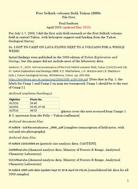
In July 2009, Dr. Paul Sanborn undertook the first soils field research at the Fort Selkirk volcanic field in central Yukon, with helicopter support and funding from the Yukon Geological Survey. This file includes the following data sets gathered from the research:
- Ft Selkirk 110114069.xls [particle size analysis data, CANTEST]
- S1090final.xlsx [chemical analysis data, Ministry of Forests & Range, Analytical Chemistry Laboratory]
- S1112final.xlsx [chemical analysis data, Ministry of Forests & Range, Analytical Chemistry Laboratory]
- Ft Selkirk 2009 soils data (updated Sept 15, 2010 and April 10, 2023).xls [consolidated lab data for all 2009 samples]
2023.2.2.7
·
Subseries
·
2009-2010, 2023
Part of Dr. Paul Sanborn fonds
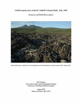
For July 1-7, 2009, Dr. Paul Sanborn did the first soils field research at the Fort Selkirk volcanic field in central Yukon, with helicopter support and funding from the Yukon Geological Survey.
Initial findings were published in the 2009 edition of Yukon Exploration and Geology, but this paper did not include most of the laboratory data:
Sanborn, P., 2010. Soil reconnaissance of the Fort Selkirk volcanic field, Yukon (115I/13 and 14). In: Yukon Exploration and Geology 2009, K.E. MacFarlane, L.H. Weston and L.R. Blackburn (eds.), Yukon Geological Survey, Whitehorse, Yukon. pp. 293-304. https://emrlibrary.gov.yk.ca/ygs/yeg/2009/2009_p293-304.pdf [Note that in Fig. 1, the labels for Camp 1 and Camp 2 on map are transposed; Camp 1 should be to the east of Camp 2.]

2023.2.2.5
·
Subseries
·
1991-2023, predominant 2004
Part of Dr. Paul Sanborn fonds
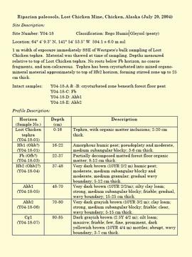
The Lost Chicken Mine, a placer gold mine in eastern Alaska, approximately 120 km west of Dawson City, Yukon, is an important fossil locality for the late Pliocene (approximately 2.5 – 3.0 million years ago). A comprehensive account of the stratigraphy and paleontology of this site was given by:
Matthews, J.V., Jr., J.A. Westgate, L. Ovenden, L.D. Carter, and T. Fouch. 2003. Stratigraphy, fossils, and age of sediments at the upper pit of the Lost Chicken gold mine: new information on the late Pliocene environment of east central Alaska. Quaternary Research 60: 9-18. https://doi.org/10.1016/S0033-5894(03)00087-5
Dr. Paul Sanborn visited the site on July 20, 2004, as part of a group led by Duane Froese (Professor, University of Alberta). The group concentrated on a single exposure (~ 2 m thick) straddling the Lost Chicken tephra, a volcanic ash bed (2.9 ± 0.4 myr) which is a major stratigraphic marker at the site. Sanborn described, photographed, and sampled this exposure, and obtained a basic set of characterization data. Intact samples were collected but thin sections were never produced.
2023.2.2.7.2
·
File
·
2009, 2023
Part of Dr. Paul Sanborn fonds
In July 2009, Dr. Paul Sanborn undertook the first soils field research at the Fort Selkirk volcanic field in central Yukon, with helicopter support and funding from the Yukon Geological Survey. This document is a complete transcription of field notes, with
soil and site photographs.
2016.7
·
Fonds
·
1988-2019
Fonds consists of the research and professorial records of Dr. Joselito Arocena, a founding faculty member of UNBC. Arocena was an internationally-recognized soil scientist and UNBC’s first Canada Research Chair. His records demonstrate his accomplishments as an academic and researcher, as well as his many and varied interdisciplinary research endeavours. Also included are selections from Arocena’s extensive photographic slide collection which illustrate his teaching, research projects, and personal interests.
Arocena, Joselito
2016.7.4
·
Series
·
2015-2019
Part of Dr. Joselito Arocena fonds
Series consists of records created and collected after Dr. Joselito Arocena's death on December 20, 2015. Includes information about Arocena's work in China, photographs and video of the unveiling of the Lito Lab, and video recordings and presentation materials from a memorial lecture for Dr. Joselito Arocena by Mike Rutherford, Hugues Massicotte, and Paul Sanborn.
2006.18
·
Fonds
·
2001-2019
The Aleza Lake Research Forest Society (ALRFS) records encompass material that was created or collected by the Society over its existence (2001-present). Records created by the ALRFS consist of administrative and operational records, as well as publications from the Society. Collected records include historical records relating to the Aleza Lake Experiment Forest gifted to the Society or its members. These include maps, photographs, reference material, and documents. Members and associates of the ALRFS also documented the history of the forest through the creation of oral history recordings and written histories such as John Revel's "Devil's Club, Black Flies, and Snowshoes".
The fonds includes a significant amount of reproduced archival material about Aleza Lake from other institutions, such as BC Archives, the Canadian Forest Service, and the BC Forest Service. Many of these reproductions were created as part of the 2006 ALRFS Natural Resources History Internship in an effort to compile the history of the research forest.
Also included are cartographic and photographic materials that depict the Aleza Lake Research Forest and surrounding areas.
2006.18.4
·
Series
·
1949-2016
Part of Aleza Lake Research Forest Society fonds
Series consists of publications created by those associated with the Aleza Lake Research Forest as well as the Aleza Lake Research Forest Society itself. Includes various clippings and articles from serial publications such as newspapers and newsletters that focus on the ALRF. Also includes publications that served as reference material on topics relevant to the ALRF.
2006.18.5.01
·
File
·
[after 1997]
Part of Aleza Lake Research Forest Society fonds
File contains photocopied excerpts from various maps of the Aleza Lake Research Forest area, some annotated.
2006.18.1
·
Series
·
1990-2016
Part of Aleza Lake Research Forest Society fonds
Series consists of records created or accumulated by the Aleza Lake Research Forest Society regarding the research forest's history. Includes oral histories and material from long-time personnel that worked at the ALRF, such as Harry Coates, John Revel, and Frank Hellenius. Also contains copies of archival records from other archival institutions that concern the history of ALRF, which were compiled as part of a 2006/2007 history internship project.
2023.2.1
·
Series
·
1976-2016
Part of Dr. Paul Sanborn fonds
Series consists of reference material collected by Dr. Paul Sanborn, including field trip guidebooks, resource inventory documents, collected sources for various areas of research, and proceedings and abstracts for conferences and workshops.
2006.18.5
·
Series
·
1925-2016
Part of Aleza Lake Research Forest Society fonds
2006.18.3
·
Series
·
1990-2016
Part of Aleza Lake Research Forest Society fonds
2006.18.4.01
·
File
·
1991-2016
Part of Aleza Lake Research Forest Society fonds
File consists of clippings from various serial publications regarding the Aleza Lake Research Forest.
2006.18.1.02
·
File
·
1990-2015
Part of Aleza Lake Research Forest Society fonds
File consists of:
- Poem written by John Revel in 1963 entitled "Cruisers (To George Silburn)"
- Eulogy for John Revel by Mike Jull, May 2015
- Obituary for John Revel in July-August 2015 issue of BC Forest Professional
- Photograph printed on foamcore of John Revel and two others checking cones from 1972 seed crop
2016.7.1
·
Series
·
1991-2015
Part of Dr. Joselito Arocena fonds
Series consists of Dr. Joselito Arocena's personal records that provide background context to his academic accomplishments, research, and professorial tenure at UNBC.
2016.7.1.3
·
File
·
1995-2015
Part of Dr. Joselito Arocena fonds
File consists of administrative records relating to the academic accomplishments of Dr. Joselito Arocena. Includes merit awards, letters of congratulation, and acceptance correspondence.
2016.7.1.4
·
File
·
1997-2015
Part of Dr. Joselito Arocena fonds
File consists of Dr. Joselito Arocena's annual reports and promotion records relating to his employment at UNBC.
2023.7
·
Fonds
·
1943-2015
Fonds consists of material created and collected by wildlife biologist Grant Hazelwood in relation to his work and research regarding wildlife, habitat, and wilderness parks. Includes material regarding Hazelwood's Tailed Frog (Ascaphus truei) research. Also includes records regarding his contracted biologist work via his consultancy business, Alpenglow Resources, on the BC Ministry of Environment's "Upper Nass Assessment Project", a project that included the biophysical mapping of the Northwest-Klappan Road Access Area.
Hazelwood, W. Grant
2023.2.2.8
·
Subseries
·
2003-2014
Part of Dr. Paul Sanborn fonds
The Kluane Lake area of SW Yukon was a continuing focus of Dr. Paul Sanborn's research for more than a decade, and generated several productive collaborations. Key themes included biological soil crusts in boreal grasslands, and interactions between aeolian sediment deposition, slope processes, and fire in boreal grassland and forest soils.
Research results appeared in these publications:
Marsh, J., Nouvet, S., Sanborn, P., and Coxson, D. 2006. Composition and function of biological soil crust communities along topographic gradients in grasslands of central interior British Columbia (Chilcotin) and southwestern Yukon (Kluane). Canadian Journal of Botany 84: 717-736. https://doi.org/10.1139/b06-026
Pautler, B.G., Reichart, G.-J., Sanborn, P.T., Simpson, M.J., and Weijers, J.W.H. 2014. Comparison of soil derived tetraether membrane lipid distributions and plant-wax δD compositions for reconstruction of Canadian Arctic temperatures. Palaeogeography, Palaeoclimatology, Palaeoecology 404: 78-88. https://doi.org/10.1016/j.palaeo.2014.03.038
Sanborn, P. and A.J.T. Jull. 2010. Loess, bioturbation, fire, and pedogenesis in a boreal forest – grassland mosaic, Yukon Territory, Canada. 19th World Congress of Soil Science, Soil Solutions for a Changing World 1 – 6 August 2010, Brisbane, Australia. http://www.iuss.org/19th%20WCSS/Symposium/pdf/0120.pdf
The 2003 field work with Darwyn Coxson was a pilot study to assess the types and distribution of biological soil crusts in boreal grasslands in the Kluane Lake area. Eight sites were visited at which the team sampled the crust and the uppermost A horizon immediately underneath it. Note that site numbers Y03-03, -04, -05, -06, -07, -09, -10 and -12 were indicated as sites 3, 4, 5, 6, 7, 9, 10 and 12 in Table 1 of Marsh et al. (2006). Additional crust sampling was conducted at two additional sites (“Peninsula”, “Silver City”) in 2004; details of sampling methods and site locations are in Marsh et al. (2006).
Results from 2009 field work were presented in Sanborn and Jull (2010), along with soil charcoal radiocarbon dates from 2003-2008 sampling which were used to reconstruct fire history in the Kluane Lake area. The 2003 (a single site at Silver City), 2004, and 2008 field work consisted of a reconnaissance of grassland and forest sites across a range of aspects and slope positions in order to recover buried soil charcoal.
2006.18.1.37
·
File
·
2013-2014
Part of Aleza Lake Research Forest Society fonds
File consists an oral history with Michael Jull recorded by Barbara Coupe. Includes are transcripts and audio recordings.

2023.2.2.8.06
·
File
·
2003-2014
Part of Dr. Paul Sanborn fonds
File consists of the following data sets:
- Kluane crust Min N (2003) S671FINL.xls [mineralizable nitrogen for biological soil crusts & upper mineral soil, 2003 samples]
- Kluane Crust samples (2004) moisture contents.xls [moisture content of air-dry 2004 crust samples from Peninsula & Silver City sites; sampling procedures & locations in Marsh et al. (20060]
- Kluane Soil Crusts (2004) chemical analyses.xls [consolidated file of chemical data for 2004 crust samples from Peninsula & Silver City sites]
- Kluane 2003 soil & crust 15N data.xls [15N natural abundance, total N, organic & inorganic C for 2003 crust & upper mineral soil samples]
- Kluane 2003 soil data.xlsx [consolidated file of chemical data for 2003 crust and mineral horizon soil samples]
- Kluane Crust 2004 total C & N data.xls
- Kluane AMS dates (2003-2008 charcoal samples).xls [radiocarbon dates from the University of Arizona Accelerator Mass Spectrometry Lab]
- Kluane soil transect - texture data.xls [2009 soil particle size analysis data, with potential lithological breaks highlighted]
- Kluane surveys 2009.xls [topographic surveys for 3 soil transects cutting across eskers along Cultus Bay Rd., SE shore of Kluane L.]
- S1061_1069_Final_Rev1.xls [lab data report from Ministry of Forests Analytical Chemistry Laboratory for 2009 transect samples: total C, inorganic C, & total N]
- 100812003 (annotated) -corrected.xls [2009 transect samples: particle size analysis data report from CANTEST]
- Kluane soil transect - master data file.xls
2006.18.1.36
·
File
·
2013
Part of Aleza Lake Research Forest Society fonds
File consists an oral history with Harry Coates recorded by Barbara Coupe. Includes a transcript and audio recording.
2006.18.1.36.1
·
Item
·
2013
Part of Aleza Lake Research Forest Society fonds
File consists an audio recording of an oral history with Harry Coates recorded by Barbara Coupe.

2006.18.1.36.2
·
Item
·
2013
Part of Aleza Lake Research Forest Society fonds
File consists an audio recording of an oral history with Harry Coates recorded by Barbara Coupe.
2006.18.1.36.3
·
Item
·
2013
Part of Aleza Lake Research Forest Society fonds
File consists a transcript of an oral history with Harry Coates recorded by Barbara Coupe.
2006.18.1.38
·
File
·
2013
Part of Aleza Lake Research Forest Society fonds
File consists an oral history with John Revel recorded by Barbara Coupe. Includes are transcripts and audio recordings.
2006.18.4.02
·
File
·
2004-2013
Part of Aleza Lake Research Forest Society fonds
File consists of the following issues of the Aleza Lake Research Forest Newsletter:
- Spring 2004
- Fall 2004
- Spring 2005
- Fall 2005
- Spring 2006
- Fall 2006
- Spring 2007
- Fall 2007
- Summer 2008
- Winter 2009
- "Highlights from 2013"
2016.7.2
·
Series
·
1990-2011
Part of Dr. Joselito Arocena fonds
The research of Dr. Joselito Arocena was extensive and multi-disciplinary. The records contained within this series of research material provide only a small glimpse of the depth and breadth of his research portfolio. The majority of Dr. Arocena's research results were released in his 200+ academic publications over the course of his career. This series contains a selection of research records that were unpublished and cover research projects that relate to the health of BC indigenous communities, the McGregor Model Forest, and others.
2016.7.2.20
·
File
·
Apr. 2011
Part of Dr. Joselito Arocena fonds
File consists of a report entitled "Annual Reclamation Report for 2010: Thompson Creek Mining Ltd., Endako Mines, Reclamation Permit M-4".
2023.2.2.1
·
Subseries
·
1988-2011
Part of Dr. Paul Sanborn fonds
Forest soil sulphur research was a continuing interest for Dr. Paul Sanborn for more than 30 years, beginning at UBC in the mid-1980s when he took a graduate course in Forest Soils from Dr. Tim Ballard. Among the things that he learned was that soils in much of BC were deficient in sulphur (S). Simultaneously, he became aware of the large amount of research on prescribed fire in BC forests, with broadcast burning being the main method of site preparation across much of the province at that time.
Sanborn undertook various projects in this area of research:
- UBC Postdoctoral Project on effects of prescribed fire on sulphur in forest soils (1988-90)
- Cluculz retrospective study (E.P. 886.10) with the BC Ministry of Forests and UNBC
- Sulphur stable isotope tracer study (E.P. 886.15) with the BC Ministry of Forests and UNBC
2006.18.4.03
·
File
·
[between 2001 and 2011]
Part of Aleza Lake Research Forest Society fonds
File consists of an Aleza Lake Research Forest pamphlet.
2023.2.2.1.3
·
Sub-subseries
·
1998-2011
Part of Dr. Paul Sanborn fonds
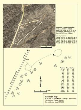
The Sulphur stable isotope tracer study (E.P. 886.15) field experiment was installed in young lodgepole pine stands at two sites in the Prince George Forest Region in 2001, with fertilizer treatments applied in late 2002. These sites are designated as Kenneth Creek (east of Prince George) and Holy Cross (south of Fraser Lake). (The Kenneth Creek installation was established near plots of the older E.P. 886.13 in the same stand.) Full experimental details, including pretreatment soil and foliar date, were given in:
Sanborn, P., R.P. Brockley, B. Mayer, M. Yun, J. Prietzel. 2005. Sulphur fertilization of lodgepole pine: a stable isotope tracer study (E.P. 886.15): Establishment report. Tech. Rep. 020. B.C. Min. For., Res. Br., Victoria, BC. http://www.for.gov.bc.ca/hfd/pubs/Docs/Tr/Tr020.htm
The Kenneth Creek site was attacked by mountain pine beetle in 2006, resulting in at least 80% tree mortality. In 2013, the stand was levelled in order to enable replanting, and due to poor communications within the Ministry of Forests, the opportunity to salvage this installation was lost. The Holy Cross site was hit by a wildfire in 2010, and most of the research plots were destroyed.
Preliminary results from foliar analysis, sufficient to demonstrate that our stable isotope tracer approach could detect fertilizer uptake, were published in:
Sanborn, P.T., R.P. Brockley, and B. Mayer. 2011. Stable isotope tracing of fertilizer uptake by lodgepole pine: foliar responses. Can. J. For. Res. 41: 493-500. https://cdnsciencepub.com/doi/full/10.1139/X10-222

2023.2.2.1.3.7
·
Item
·
[2010?]
Part of Dr. Paul Sanborn fonds
Document is a research installation layout map for the Kenneth Creek site of the Sulphur stable isotope tracer study (E.P. 886.15).
2023.2.2.1.3.8
·
File
·
2003-2010
Part of Dr. Paul Sanborn fonds
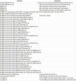
Data sets for the Sulphur stable isotope tracer study (E.P. 886.15) include:
- 03-095 UNBC PS-For.xls Particle size analyses (Kenneth Creek 0-20 & 20-40 cm)
- 03-096 UNBC PS-For.xls Particle size analyses (Holy Cross 0-20 & 20-40 cm)
- 082037.xls XRF elemental analysis (Holy Cross pedon)
- 082038.xls XRF elemental analysis (Kenneth Creek pedon)
- 084996.xlsx XRF elemental analysis (HC & KC parent materials)
- EP 886 15 S isotope data (2001-2005) - foliage_completed (Feb 18).xls Pine foliage d34S (total S & total SO4-S)
- EP 886.15 2003 Foliage & Soil Chemistry Summary.xls
- EP 886.15 Foliar Analyses (selected) 2001-2006.xls Total N & S, SO4-S
- EP 886.15 Holy Cross & Kenneth Creek 2005 foliage.xls
- EP 886.15 Holy Cross & Kenneth Creek 2006 foliage.xls
- EP 886.15 Holy Cross 2001 FH (S516FINL).xls
- EP 886.15 Holy Cross 2001 Foliage (T727FINL).xls
- EP 886.15 Holy Cross 2001 Litter (S515FINL).xls
- EP 886.15 Holy Cross 2001 Mineral Soil (0-20 cm) (S507FINL).xls
- EP 886.15 Holy Cross 2002 Foliage (T785FINL).xls
- EP 886.15 Holy Cross 2003 FH (S642FINL).xls
- EP 886.15 Holy Cross 2003 Foliage (T836FINL).xls
- EP 886.15 Holy Cross 2003 Litter (S641FINL).xls
- EP 886.15 Holy Cross 2003 Mineral Soil (0-20 cm) (S643FINL).xls
- EP 886.15 Holy Cross 2004 FH (S702FINL).xls
- EP 886.15 Holy Cross 2004 Foliage (T904FINL).xls
- EP 886.15 Holy Cross 2004 Litter (S701FINL).xls
- EP 886.15 Holy Cross 2004 Mineral Soil (0-20 cm) (S703FINL).xls
- EP 886.15 Kenneth Creek 2001 FH (S521FINL).xls
- EP 886.15 Kenneth Creek 2001 Foliage (T727FINL).xls
- EP 886.15 Kenneth Creek 2001 Litter (S520FINL).xls
- EP 886.15 Kenneth Creek 2001 Mineral Soil (0-20 cm) (S508FINL).xls
- EP 886.15 Kenneth Creek 2001 Mineral Soil (20-40 cm) (S509FINL).xls
- EP 886.15 Kenneth Creek 2002 Foliage (T785FINL).xls
- EP 886.15 Kenneth Creek 2003 FH (S645FINL).xls
- EP 886.15 Kenneth Creek 2003 Foliage (T837FINL).xls
- EP 886.15 Kenneth Creek 2003 Litter (S644FINL).xls
- EP 886.15 Kenneth Creek 2003 Mineral Soil (0-20 cm) (S646FINL).xls
- EP 886.15 Kenneth Creek 2003 Mineral Soil (20-40 cm) (S647FINL).xls
- EP 886.15 Kenneth Creek 2004 FH (S705FINL).xls
- EP 886.15 Kenneth Creek 2004 Foliage (T905FINL).xls
- EP 886.15 Kenneth Creek 2004 Litter (S704FINL).xls
- EP 886.15 Kenneth Creek 2004 Mineral Soil (0-20 cm) (S706FINL).xls
- EP 886.15 Kenneth Creek 2004 Mineral Soil (20-40 cm) (S707FINL).xls
- EP 886.15 Sample Inventory.xls Listing of MoF Lab Job No.'s
- Fertilizer March 2003.xls d34S data for commercial fertilizer S sources
- hc_2002.xls Initial (2002) pine tree measurement data - Holy Cross
- kc_2002.xls Initial (2002) pine tree measurement data - Kenneth Creek
2023.2.2.13
·
Subseries
·
2007-2010
Part of Dr. Paul Sanborn fonds
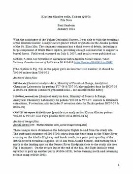
With the assistance of the Yukon Geological Survey, Dr. Paul Sanborn was able to visit the terminus of the Klutlan Glacier, a major outlet glacier which originates in the Alaska portion of the St. Elias Mountains. The stagnant terminus has a thick cover of debris, including a large component of White River tephra, providing enough soil material to support a boreal forest. Field work occurred on July 8, 2007, and results were published as:
Sanborn, P. 2010. Soil formation on supraglacial tephra deposits, Klutlan Glacier, Yukon Territory. Canadian Journal of Soil Science 90: 611-618. https://doi.org/10.4141/cjss10042
2023.2.2.1.3.6
·
Item
·
[2010?]
Part of Dr. Paul Sanborn fonds
Document is a research installation layout map for the Holy Cross Creek site of the Sulphur stable isotope tracer study (E.P. 886.15).
2006.18.4.05
·
File
·
2010
Part of Aleza Lake Research Forest Society fonds
File consists of two copies of the Forest History Association of British Columbia Newsletter, Issue No. 88, published July 2010. This issue contains a synopsis of the 2009 Forest History Conference that look place at UNBC Prince George.
2023.2.2.6
·
Subseries
·
1983-2010
Part of Dr. Paul Sanborn fonds
During the 1980s, Agriculture Canada pedologists Scott Smith (retired from Summerland Research Station, formerly based in Whitehorse) and Charles Tarnocai (retired from Central Experimental Farm, Ottawa) had a large field program which addressed the trends in soil development in the central Yukon. Across this region, particularly between Whitehorse and Dawson City, the land surfaces and surficial deposits vary greatly in age due to the differing extents of glaciations over the past ~2 million years.
This work built on a pioneering study from the previous decade:
Foscolos, A.E., N.W. Rutter, and O.L. Hughes. 1977. The use of pedological studies in interpreting the Quaternary history of central Yukon Territory. Bulletin 271. Geological Survey of Canada, Ottawa. 48 p. https://doi.org/10.4095/103066
Tarnocai and Smith presented their results in two publications:
C. A. S. Smith, C. Tarnocai, and O. L. Hughes. 1986. Pedological investigations of Pleistocene glacial drift surfaces in the central Yukon. Géographie physique et Quaternaire, 40 (1): 29–37. https://doi.org/10.7202/032620ar
Tarnocai, C. and C. A. S. Smith. 1989. Micromorphology and development of some central Yukon paleosols, Canada. Geoderma 45 (2): 145-162. https://doi.org/10.1016/0016-7061(89)90047-5
Tarnocai and Smith shared the unpublished data and soil samples from this work with Dr. Paul Sanborn, and this resulted in a student project published as:
Daviel, E., P. Sanborn, C. Tarnocai, and C.A.A. Smith. 2011.Clay mineralogy and chemical properties of argillic horizons in central Yukon paleosols. Canadian Journal of Soil Science 91: 83-93. https://doi.org/10.4141/cjss10067

2023.2.2.6.4
·
File
·
2010
Part of Dr. Paul Sanborn fonds
This data set consists of elemental analysis data for selected B horizons from Wounded Moose paleosols sampled by Tarnocai and Smith. The file includes the original ALS lab report, additional panes showing comparison of replicates, and calculation of a weathering index.
2023.2.2.8.20.76
·
Item
·
2009
Part of Dr. Paul Sanborn fonds
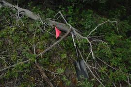
Photograph depicts a Kluane Lake transect 3 location.
2023.2.2.12
·
Subseries
·
2007-2009
Part of Dr. Paul Sanborn fonds
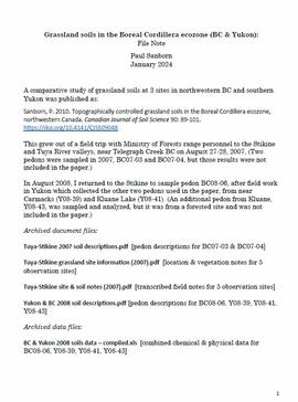
A comparative study of grassland soils at 3 sites in northwestern BC and southern Yukon was published as:
Sanborn, P. 2010. Topographically controlled grassland soils in the Boreal Cordillera ecozone, northwestern Canada. Canadian Journal of Soil Science 90: 89-101. https://doi.org/10.4141/CJSS09048
This grew out of a field trip with Ministry of Forests range personnel to the Stikine and Tuya River valleys, near Telegraph Creek BC on August 27-28, 2007. (Two pedons were sampled in 2007, BC07-03 and BC07-04, but those results were not included in the paper.)
In August 2008, Dr. Paul Sanborn returned to the Stikine to sample pedon BC08-06, after field work in Yukon which collected the other two pedons used in the paper, from near Carmacks (Y08-39) and Kluane Lake (Y08-41). (An additional pedon from Kluane, Y08-43, was sampled and analyzed, but it was from a forested site and was not included in the paper.)
2023.2.2.12.5
·
File
·
2007-2009
Part of Dr. Paul Sanborn fonds
File contains the following data sets:
- BC & Yukon 2008 soils data – compiled.xls [combined chemical & physical data for BC08-06, Y08-39, Y08-41, Y08-43]
- S925finl.xls [chemical analysis data, Ministry of Forests & Range, Analytical Chemistry Laboratory for pedons BC07-03 & BC07-04; also includes data for Y07-06 & Y07-07 (Klutlan Glacier – see associated file note)]
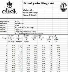
- S979finl(revised) – PS edits.xls [chemical analysis data, Ministry of Forests & Range, Analytical Chemistry Laboratory for BC08-06, Y08-39, Y08-41, Y08-43]
- S994finl_revised.xls [chemical analysis data, Ministry of Forests & Range, Analytical Chemistry Laboratory for BC07-04 (CaCO3-equiv, total & inorganic C, pyrophosphate, oxalate & dithionite extractions) & selected horizons from BC07-07 & BC07-09 (Nazko basaltic soils))
- CANTEST lab report 91010076.pdf [particle size analyses for BC08-06, Y08-39, Y08-41, Y08-43]
- CANTEST lab report 90206003.pdf [particle size analyses for Tuya pedons BC07-03 & BC07-04 & Klutan Glacier pedons Y07-06 & Y07-07]

2023.2.2.7.4.006
·
Item
·
2009
Part of Dr. Paul Sanborn fonds

2023.2.2.7.4.008
·
Item
·
2009
Part of Dr. Paul Sanborn fonds