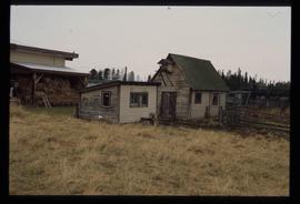
Image depicts an old beehive burner at an uncertain location.
Image depicts an old and abandoned cabin with ivy growing up the side. The location is uncertain.
Image depicts the CN Station in Penny B.C. A woman, possibly Sue Sedgwick, is sitting against the outside wall.
Image depicts the CN Station in Penny B.C.
Image depicts an aerial view of a lake and large, forested areas. The location is uncertain.
Image depicts an aerial view of a landscape at an uncertain location.
Image depicts several houses and the Giscome saw mill in Giscome, B.C. in the background. Map coordinates 54°04'20.9"N 122°21'53.1"W
Image depicts the mill site at Giscome and its beehive burner. Map coordinates 54°04'19.7"N 122°22'04.7"W
Image depicts a blue house for sale on Upper Fraser Rd. Location is likely Upper Fraser, B.C.
Image depicts Snowpeak above Longsworth B.C.
Image depicts four unidentified individuals walking along the bank of the Fraser River in Longworth, B.C.
Image depicts numerous piles of wood in Longworth, B.C.
Image depicts Sue Sedgwick standing in front of an old, run-down house somewhere in or near Penny, B.C.
Image depicts a beehive burner somewhere in or near Penny, B.C.
Image depicts a house in Upper Fraser with the residential area in the background. Map coordinates 54°07'02.8"N 121°56'37.5"W
Image depicts an old shack buried in snow, possibly in Newlands, B.C.
Image depicts a Catholic church in Giscome, B.C. Map coordinates 54°04'15.5"N 122°21'52.1"W
Image depicts the creek flowing into Eaglet Lake. A grey area of hill on the right side of the image appears to be the Giscome Quarry. Map coordinates 54°04'26.2"N 122°22'04.3"W
Image depicts the Oblates of Mary Immaculate Catholic Church in Aleza Lake, B.C. Map coordinates 54°07'08.2"N 122°02'00.0"W
Image depicts a train on the Hansard Bridge across the Fraser River looking west. Map coordinates 54°04'37.7"N 121°50'39.9"W
Image depicts a cookhouse at an uncertain location.
Image depicts two small sheds at an uncertain location. The slide labels them as "Giscome bldgs in Blackburn."
Image depicts a road with a guardrail and open fields somewhere near Dawson Creek, B.C.
Image depicts a section of the Peace River blocked off by the W.A.C. Bennett Dam. The dam itself is not visible in the image.
Image depicts a dam on what is possibly the Peace River.
Image depicts a stretch of highway, possibly Highway 29 or 97.
Image depicts the Clayhurst Ferry on the Peace River.
Image depicts what appears to be a motel in Hudson's Hope, B.C. The slide is labelled "camp HH."
Image depicts the Peace River, possibly near Hudson's Hope, B.C.
Image depicts an unidentified individual standing in front of a rock face with visible sediment layers. Located somewhere in the Peace River Region, possibly near Hudson's Hope.
Image depicts a wall of rock with visible sediment layers at an uncertain location in the Peace River Region, possibly near Hudson's Hope.
Image depicts an unidentified woman with a camera sitting on the bank of a river.
Image depicts a group of individuals who appear to be searching through the rocks near a railway track. It is possibly part of an educational trip.
Image depicts several businesses in a small section of Chetwynd, B.C. There is a motor hotel and a half-visible sign for an Esso gas station.
Image depicts a number of townhouses in Chetwynd, B.C.
Image depicts several unidentified individuals lying on a hill outside what is most likely the W.A.C. Bennett Dam in Hudson's Hope, B.C.
Image depicts the Peace Canyon Dam and generating station under construction on the Peace River.
Image depicts several unidentified individuals standing on a bridge; it possibly crosses the peace River.
Image depicts several unidentified individuals standing in front of a store selling honey.
Image depicts a large group of people examining the sediment layers in a rock face.
File contains slides depicting the Peyto Glacier.
Image depicts the log building that acts as the public library in Hudson's Hope, B.C.
Image depicts the Peace River.
Image depicts a set of railway tracks, and a building with a sign which reads: "Telegraphs." The location is uncertain, but possibly in the Peace River Region.
Image depicts a view of some farm land in Chetwynd, B.C.
Image depicts the Peace River and visible layers of sediment deposits in the surrounding cliffs.
Image depicts the interior of a store, possibly in Fort St. John, B.C.
Image depicts several unidentified individuals exiting a church made of logs, possibly in Fort St. John, B.C.
Image depicts a view of Fort St. John, B.C.