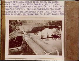
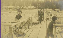
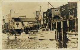
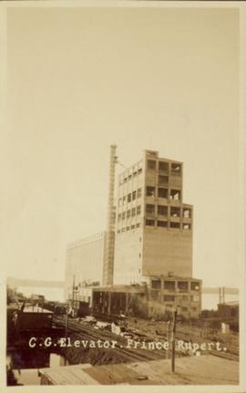
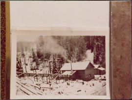
Showing 1971 results

Archival description
1322 results with digital objects Show results with digital objects
2007.17.1.6 · Item · [ca. 1935]
Part of James Joseph Claxton Photograph Collection

Photograph depicts two wooden buildings in a snow covered forest environment. Photo is adhered to paper backing, upon which handwritten annotation on recto reads: “Quesnelle Quartz Mining Co. Hixon BCTaken in mid 1930ies. Power house from rear. Present day (1973) Logging road would run through powerhouse at immediate rear of it at which you are looking. Tom Marsh Box 150 Squamish BC 1978.12”

2007.17.1.9 · Item · [ca. 1935]
Part of James Joseph Claxton Photograph Collection

Photograph depicts a dam and spillway obstructing a creek. Photo is adhered to paper backing, upon which handwritten annotation on recto reads: “This is the dam and spillway about nine miles up Hixon Creek belonging to the Hixon Creek Cariboo Gold Co., whose main camp on Hixon Creek was at the falls. A fellow Sterling or Bill Tordiffe & I took a contract to cut the logs for this dam in January 1934. The first few winters Quart [sic] Quesnel Quartz had to shut down for snow”

Oilweek: Pipeline Wall Map
2009.6.13.45.14 · Item · Nov. 1976
Part of The Honourable Iona Campagnolo fonds

Map depicts existing oil lines, oil lines proposed or under construction, product lines, existing gas lines, gas lines proposed or under construction, LPG lines, and LPG lines proposed in Canada and Northern USA.

2009.7.1.260 · Item · 24 April 1913
Part of Archdeacon W. H. Collison fonds

Foreground shows a rocky shore covered in debris. A small crowd is visible along the coastline, and there are foggy outlines of hills beyond the water. Annotation on recto reads: "McRae Bros After the Blast 24th Apr. 13."

2009.7.1.263 · Item · 21 January 1914
Part of Archdeacon W. H. Collison fonds

Photograph of a large explosion next to a huge pile of debris. Buildings are visible on either side and railroad track can be seen in the foreground. Annotation on recto reads: "The Last Big Blast, Prince Rupert BC 21 Jan 1914 McRae Bros. Photo"

2009.7.1.265 · Item · 24 April 1913
Part of Archdeacon W. H. Collison fonds

Photograph of a large explosion on a rocky shoreline. A bridge is visible in the foreground and a body of water is partially visible in the background. Annotation on recto reads: "McRae Bros Moving Mountains at Prince Rupert BC Apr 24th"

Parker photograph collection
2011.13 · Collection · [between 1910 and 1930]

The photographs depict the geographic areas of Stewart, BC, Boundary Pass, Nelson River, Bitter Creek Glacier, Portland Canal, Red Cliff and Bear Creek; as well as the ships “Camosun” and “S.S. Prince George.” Types of subjects identified in this collection include: community life, surveying, mining and transportation (i.e. dog-sledding, horse and buggy, and the Portland Canal Short Line Railway “P.C.S.L. Rlwy”).

2009.7.1.053 · Item · [ca. 1915?]
Part of Archdeacon W. H. Collison fonds

Photograph depicts buildings visible through clearing in trees. Water crosses foreground, hills visible in background.

Handwritten annotation on verso reads: "Dry dock / Prince Rupert B.C."

2009.7.1.133 · Item · [ca. 1910?]
Part of Archdeacon W. H. Collison fonds

Photographs depict groups of men gathered on ice. Herbert leans over behind two friends seated on ice sled (son of Marion and Archdeacon W.H. Collison). Pile of caught fish can be seen in foreground behind large whole in ice.

Handwritten annotations on verso read: "Oolichan Fishing Fishing Bay Nass River"; "Uncle Herbert with Indian friends fishing for oolichan through the ice."

Logging
2012.13.1.122.12 · Item · 1977
Part of J. Kent Sedgwick fonds

Image depicts a logging area somewhere near Prince George, B.C.

Sawmill - Saw
2012.13.1.122.18 · Item · June 1980
Part of J. Kent Sedgwick fonds

Image depicts a saw cutting a log in half at a saw mill in Prince George, B.C.

Large Indoor Saw
2012.13.1.122.19 · Item · June 1980
Part of J. Kent Sedgwick fonds

Image depicts a large saw at an indoor location, likely in a saw mill somewhere in Prince George, B.C.

Tree Cutter
2012.13.1.122.26 · Item · May 1980
Part of J. Kent Sedgwick fonds

Image depicts two unidentified individuals examining a thick log still attached to the machine that cut it down. It is located somewhere in Prince George, B.C.

Britannia Mine Entrance?
2012.13.1.54.52 · Item · July 1980
Part of J. Kent Sedgwick fonds

Image depicts the entrance to a mine with an unknown individual present. It is possibly the entrance to the closed Britannia Mine in the Howe Sound Region.