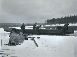
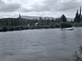
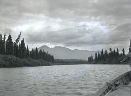
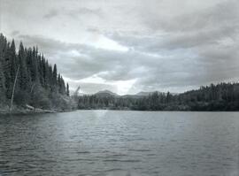
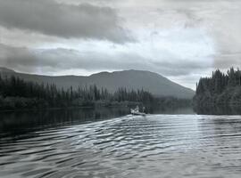
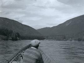
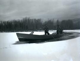
Photograph depicts three men in a boat using long poles to steer a boat through an ice covered river section at Finlay Forks.
Photograph depicts five men repairing a boat pulled up on a snow covered shoreline beside the river at Finlay Forks.
Photograph depicts two men standing on a boat floating between ice chunks down Finlay River below Deserter Canyon.
Photograph depicts a sleeping dog and a man holding up a bottle standing between a small campfire and box filled with dishes. In the background of the image there is a forested landscape and a river to the right of the man.
Photograph depicts a snowy mountain range to the south of Wedge Creek with a forested area at the base.
Photograph depicts two horses loaded with packs walking across a wooden bridge leading over Wedge Creek.
Photograph depicts two men standing near two horses in front of a tall log cache in a forested environment.
Photograph depicts a man (Ed Short) standing on a boulder in front of a hillside covered with grass and trees.
Photograph depicts two men and a dog standing in a grassy field at Duck Creek in front of a forested landscape with a mountain range in the background.
Photograph depicts two men, Bill Martin and Clarence Waldof, picking blueberries along a hillside surrounded by their bags and a dog.
Photograph depicts a frozen pond located in a snowy landscape on the east side of Copper Mountain.
Photograph depicts two men (Bill McPhee and Shorty Weber) standing at the summit of Copper Mountain with a snowy mountain range visible in the background of the image.
Photograph depicts (from left to right) Bill McPhee, Frank 'Shorty' Weber, and another man resting along the rocky terrain on the west slope of Copper Mountain with a forested area at the base of the mountain. In the background of the image another mountain range is visible. The location of the photograph is noted to be at Copper Mountain; however, that name does not appear to be in current use. Location is assumed to be somewhere in the vicinity of 55.979291, -125.208415, near what is currently named Wasi Peak.
Frank ‘Shorty’ Weber had a trapline on the upper Ingenika for over 30 years. and he was well-known in the Finlay River area.
Photograph depicts Copper Mountain with forested area at base and grassy area in the foreground.
Photograph depicts four men seated around a small camp in front of Copper Mountain. The location of the photograph is noted to be at Duck Creek at Copper Mountain; however, those names may no longer be in current use. Location is assumed to be approximately 55.979291, -125.208415 near what is currently named Wasi Peak.
Photograph depicts three men sitting in a circle in a clear area near a sparsely forested area in front of a snowy mountain range. The location of the photograph is noted to be at Duck Creek at Copper Mountain; however, those names may no longer be in current use. Location is assumed to be approximately 55.979291, -125.208415 near what is currently named Wasi Peak.
Photograph depicts (from left to right) Bill McPhee, an unidentified man, a dog, and Frank 'Shorty' Weber standing in tall meadow grass in front of a sparsely forested landscape in front of a mountain range. The location of the photograph is noted to be at Duck Creek below Copper Mountain; however, those names may no longer be in current use. Location is assumed to be approximately 55.979291, -125.208415 near what is currently named Wasi Peak.
Frank ‘Shorty’ Weber had a trapline on the upper Ingenika for over 30 years. and he was well-known in the Finlay River area.
Photograph depicts Frank 'Shorty' Weber steering a dug-out canoe on the Omineca River. The background of the photograph depicts log cabins at Old Hogem built along the shoreline of the river in front of a forest with a mountain ridge in the background.
Frank ‘Shorty’ Weber had a trapline on the upper Ingenika for over 30 years. and he was well-known in the Finlay River area.
Photograph depicts a wide view of the Omineca River with a man standing on a boat in the right corner of the image. In the background the river a forested shoreline and mountain range are visible.
Photograph depicts the view from Germansen Lodge of Omineca River with a forested shoreline and mountain ranges in the background.
Photograph depicts Ralph Meiser and another man ("Crites"?) paddling a wooden boat on the Omineca River near Germansen Landing.
Photograph depicts two men and two dogs resting near a wooden rowboat stopped along the shoreline of upper Osilinka River near Swiggums mining claims.
Photograph depicts Emil Bronlund at the back of a wooden motor boat resting after a swim in the Omineca River, located near Germansen Landing.
Photograph depicts Emil Bronlund and another man kneeling at camp with a tent and cooking fire. The camp is located at Little Canyon near the upper Omineca River.
Photograph depicts the rocky shoreline and forest environment at the entrance to Little Canyon viewed from the Omineca River.
Photograph depicts a man siting in a wooden boat on the Omineca River leading to the entrance of Little Canyon toward a forested shoreline.
Photograph depicts two men inspecting dirt at Swiggums' mining claim near Osilinka River.
Photograph depicts Clarence Waldof sitting on the bow end of a wooden boat floating on End Lake off the Osilinka River with a forested landscape along the shoreline. A mountain range is visible in the background of the photo.
Photograph depicts men fishing off a rocky point between the Omineca and Osilinka Rivers.
Photograph depicts two large totem poles on either side of the front steps of Kwakwaka'wakw cedar plank houses. An unidentified woman and three small children can be seen in foreground. A second building stands in background on right. Handwritten annotation on recto of photograph states: "New Hazelton". However, this annotation has been determined to be incorrect; this photograph is believed to depict Alert Bay. The nearest tall pole seen in the picture may be "Raven of the Sea" carved by Mungo Martin in 1902.
Photograph depicts Heber Maitland speaking at microphone with Iona Campagnolo, Mrs. Ivy Maitland, and others seated at the opening of the Haisla Recreation Centre in Kitamaat Village.
Photograph depicts Iona Campagnolo, Heber Maitland, Mrs. Ivy Maitland, and others at the opening celebrations of the Haisla Recreation Centre in Kitamaat Village.
Photograph was taken during a tour of the Skeena riding in the summer of 1978. Unidentified man walks in background.
Handwritten annotation on verso reads: “June 78, Kitamaat, Heber Mrs. Maitland”.
Photograph depicts Heber Maitland holding a commemorative plaque at the opening of the Haisla Recreation Centre in Kitamaat Village.
Photograph depicts Heber Maitland cutting the ribbon at the opening of the Haisla Recreation Centre in Kitamaat Village.
Photograph depicts Heber Maitland with cut ribbon at the opening of the Haisla Recreation Centre in Kitamaat Village.
Photograph depicts Heber Maitland and three unknown men at the opening of the Haisla Recreation Centre in Kitamaat Village.
Item is a hand drawn and coloured map by the City of Prince George Planning Department depicting Hart Highway neighbourhood area existing land use in 1976.
City of Prince GeorgeFonds consists of personal papers, books, manuscripts, photographic materials, audio recordings and electronic records arranged into five series, which relate to Mr. Fawcett's personal life, his creative works and his relationships with members of the literary community.
Fawcett, Brian