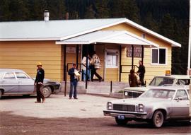
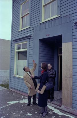
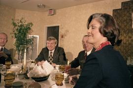
Photograph depicts Iona Campagnolo, Earl Mah, and an unidentified Chinese senior citizen standing by the front door of the Prince Rupert Chinese Senior Citizens Centre. Photograph was
Photograph depicts Iona Campagnolo and Premier Peter Lougheed talking with unidentified people at the Crest Hotel in Prince Rupert during Campagnolo's Skeena Riding tour. Several unidentified people talk behind them.
Photograph depicts Iona Campagnolo and Premier Peter Lougheed talking with three unidentified men at the Crest Hotel in Prince Rupert during Campagnolo's Skeena Riding tour. Several unidentified people talk behind them.
Photograph depicts Iona Campagnolo, Premier Peter Lougheed and Mayor Peter Lester sitting at a table and talking at the Crest Hotel in Prince Rupert during Campagnolo's Skeena Riding tour. An unidentified bartender is in the background.
Photograph depicts Iona Campagnolo, Premier Peter Lougheed, Mayor Peter Lester sitting at a table and talking at the Crest Hotel in Prince Rupert during Campagnolo's Skeena Riding tour.
Photograph depicts Iona Campagnolo, Premier Peter Lougheed, Mayor Peter Lester and an unidentified man sitting at a table and talking at the Crest Hotel in Prince Rupert during Campagnolo's Skeena Riding tour. Campagnolo's eyes are closed.
Photograph depicts Premier Peter Lougheed and an unidentified man sitting at a table and talking at the Crest Hotel in Prince Rupert during Campagnolo's Skeena Riding tour. An unidentified group of people sit a table behind them.
Image depicts an old, boarded-up store/office in Lamming Mills, B.C.
Image depicts the Giscome Community Hall in Giscome, B.C. Map coordinates 54°04'18.5"N 122°21'57.7"W
Image depicts the community hall in Penny, B.C.
Image depicts a group of people in Cottonwood Park with an individual, possibly former mayor Elmer Mercier, making an announcement.
Image depicts a gathering of people for an uncertain event at an uncertain location, possibly in Lillooet, B.C. A few tents are set up in the picture.
Image depicts the old community hall in Soda Creek, B.C.
Item is a hand drawn and coloured map by the City of Prince George Planning Department depicting Hart Highway neighbourhood area existing land use in 1976.
Sans titreItem is a hand drawn and coloured map by the City of Prince George Planning Department depicting the Blackburn neighbourhood development area's proposed sector plan in 1976.
Item is a hand drawn and coloured map by the City of Prince George Planning Department depicting the VLA neighbourhood proposed zoning in 1976.
Item is a hand drawn and coloured map by the City of Prince George Planning Department depicting public representations at the VLA neighbourhood zoning hearing that occurred on April 12, 1976.
Item is a hand drawn and coloured map by the City of Prince George Planning Department depicting zoning proposed by Prince George Alderman A. Stauble for the VLA neighbourhood.
Item is a hand drawn and coloured map by the City of Prince George Planning Department depicting existing land use for the Van Bow neighbourhood area.
Item is a hand drawn and coloured map by the City of Prince George Planning Department depicting existing zoning for the Van Bow neighbourhood area. Also includes two hand-drawn mylar overlays for the map; one showing "Opportunities & Constraints" such as housing age and condition and the other showing "Subdivision Activity" over decades of development in the Van Bow area.
Item is a map annotated in colour by the City of Prince George Planning Department depicting major residential development proposals from June 1975 to August 1977 in the City of Prince George. This map was drawn for the City of Prince George interim Community Plan.
Item is a map depicting proposed land use between 1978 and 2012 in the City of Prince George. This map was drawn for the City of Prince George Community Plan; this particular version of the map was displayed in City of Prince George council chambers through 1979.
Item is a map depicting the areas of spring and fall shadow in the Peden Hill neighbourhood in Prince George.
Item is a map depicting land use in the Vancouver Carney study neighbourhood area in Prince George. Also includes two mylar overlays that show the outlines of "unit 2" and "unit 3" development areas.
Item is Map 3 of a group of five maps relating to a City of Prince George Study of Construction Aggregates by the firm Willis, Cunliffe, Tair & Company Limited. Map 3 shows geology of the Prince George area and known sources of construction aggregates.
This map is part of Schedule B of the 1993 Official Community Plan, Bylaw No. 5909 for the City of Prince George. This particular map depicts the northeast area of the City of Prince George, including the industrial areas on Prince George Pulpmill Road and Northwood Pulpmill Road along the Fraser River.
This street map of the VLA area in Prince George includes property outlines and street numbers.
This map is the October 2006 amendment (Bylaw 7807) of the Schedule C of the 2001 Official Community Plan, Bylaw No. 7281 for the City of Prince George. This Schedule C map shows the long range land use for the City of Prince George.
Drawing depicts visual notes taken at the 2020 Public Health Summer Institute with the theme "Think Globally, Act Locally: Public Health and the Anthropocene". Themes related to the COVID-19 pandemic are depicted.
Photograph depicts the Cassiar townsite behind shadow in foreground. Plantsite can be seen including the mill, dry rock storage building, tailings pile, and many other buildings. Mountains in background. Handwritten annotation on recto: "<- 13 1/2" ->". (This photograph was made into a promotional poster.)
Photograph depicts long wood building speculated to be the Community Centre at Cassiar, B.C. Sports net stands in right foreground. Flag pole, barrel, and stand of trees can be seen in front of building. Mountains in background. Handwritten annotation on verso of photograph: "1961".
Photograph depicts four houses in line behind trees and steel drums. Road in foreground, mountains in background. Handwritten annotation on verso of photograph: "1961".
Photograph depicts women, men, and children standing in store, some pushing grocery carts. Two women stand near till, one wearing long white professional jacket. Young man named Lobbes stands behind counter on far right, wearing white shirt. Store appears to be stocked with groceries and general supplies. Handwritten annotation on recto of photograph: "RIGHT TOMMY LOBBES".
Photograph depicts priest wearing black cassock on front steps of Cassiar Catholic Church. Bell tower and trees in background. Handwritten annotation on recto of photograph: "FATHER POULET".
Photograph depicts man with badminton racket playing to right of net in gymnasium. Stage, doors, chairs, and basketball hoops visible in background. Door to right of stage led to squash court and upper balcony.
Photograph depicts woman with badminton racket playing to right of net in gymnasium. Stage, doors, chairs, and basketball hoops visible in background. Door to right of stage led to squash court and upper balcony.
Photograph depicts two men with badminton rackets in foreground of gymnasium, net visible on far right. Doors, tables, and chairs visible in background.
Photograph depicts men seated at tables in snack bar, counter and shelves in background, fluorescent lights hanging from ceiling. Women believed to be Hilde Voss semi-visible behind counter. Two men are circled with pen. Handwritten annotation on recto of photograph: "BACK MORRIS[sic?] BISSON / FRONT PETE VOSS".
Photograph depicts long bunkhouse buildings located between the Cassiar plant and townsite. They were originally used seasonally by university students, or by new employees on waiting lists for the more accommodating panabode "Winter Bunkhouses" (see item 2000.1.1.3.19.113). These buildings are speculated to be bunkhouses number 86, 87, and 88. Trees cross midground; new mill building, tailings pile, and mountains visible in background. Handwritten annotation on verso of photograph: "Cassiar June 15 71".
Photograph depicts trees and pickup trucks in front of long building speculated to be an apartment residence.
Photograph depicts man on dirt road, many small buildings on left. Mountains in background. Corresponding note on accompanying photo description page: "12. Temporary Campsite."
Typed annotation in black ink on recto of photograph: "looking through pass-way into kitchen from dining room". Photograph depicts side view of what appears to be a stove and other kitchen equipment.
Photograph depicts unidentified men and women at counter in Royal Bank at Cassiar, B.C. Two employees stand behind counter.
Photograph depicts unidentified men and women in front of yellow building with the signs "POST OFFCE / BUREAU DE POST / CASSIAR, B.C.", "NO PARKING". Three cars (one with siren on top) can be seen in foreground; forest in background.
Photograph depicts unidentified man wearing apron while handling fruit in produce section of grocery store. Second individual semi-visible on far right.
Photograph depicts three unidentified individuals browsing magazine section of store.
Photograph depicts three unidentified women (two behind counter) at till in grocery store. "MEAT" and FROZEN FOOD" sections visible in background.
Photograph depicts four unidentified individuals walking in front of Cassiar Private Hospital. Sign in foreground reads "VISITING HOURS EVERY DAY / 2 PM - 4 PM / 7 PM - 8 PM".
Photograph depicts six unidentified individuals in interior of curling rink.