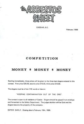
Mostrando 491 resultados

Archival description
390 resultados con objetos digitales Muestra los resultados con objetos digitales
5840 & 5870 Bench Plan for 1972
2000.1.2.6.2 · Item · November 30, 1972
Parte de Cassiar Asbestos Corporation Ltd. fonds

This map depicts the generalized pit layout and estimated waste extraction areas for benches 5840 and 5870. Annotated details include numerical bench markers as well as extraction dates. The hand drawn plan consists of solid and dotted lines drawn with green and red pencil.

5840 Bench Plan for October 1972
2000.1.2.6.7 · Item · October 1972
Parte de Cassiar Asbestos Corporation Ltd. fonds

This map depicts the pit layout and estimated waste extraction areas for 5840 bench for the end of September to November. Extraction dates, approximate extraction tonnages and ore, waste and talus locations are included throughout the plan. Annotated details include numerical bench markers, extraction dates, approximate total tonnages as well as waste and ore tonnage calculations for October. The hand drawn plan consists of solid and broken lines drawn with red, blue, orange and lead pencils as well as black ink.

5870 Bench Plan for October 1972
2000.1.2.6.8 · Item · October 1972
Parte de Cassiar Asbestos Corporation Ltd. fonds

This map depicts the pit layout and estimated waste extraction areas for 5870 bench for the end of August to November. Extraction dates, approximate extraction tonnages and ore, waste and talus locations are included throughout the plan. Annotated details include numerical bench markers, extraction dates, approximate extraction tonnages, ore, waste and talus locations as well as waste, ore, talus and total tonnage calculations for October. The hand drawn plan consists of solid and broken lines drawn with red, blue, orange and lead pencils as well as black ink.

6350 Bench Plan for 1972
2000.1.2.6.9 · Item · October 4, 1972
Parte de Cassiar Asbestos Corporation Ltd. fonds

This map depicts the pit layout and estimated waste extraction areas for 6350 bench. Extraction dates accompanied by its total tonnages are located within each planned area. Annotated details include extraction dates, approximate total tonnages per area as well as extraction dates, total planned and broken tonnages and total tonnages from December 31, 1970 from a survey done in September 30. The hand drawn plan consists of solid lines drawn with red, green and orange colored pencils.

Ore Type and Geology Map
2000.1.2.6.13 · Item · December 31, 1972
Parte de Cassiar Asbestos Corporation Ltd. fonds

This map depicts the ore type and geology that can be found among each of the bench layers. Classifications and grades of ore are included within it. Different bench layers are included in the map. Annotations include a title in the back of the map written out as "1972 BENCH PLANS".

The Cassiar "?" Mar. 1956
2000.1.3.1.001 · Item · 7 Mar. 1956
Parte de Cassiar Asbestos Corporation Ltd. fonds

On March 7, 1956 the Cassiar Reporters Guild published one issue of an untitled newspaper simply titled "The Cassiar '?'" (vol.1, no.1) along with a "name that newspaper" contest call out to the local community. It is believed that no other issue of this first volume was published until December 7, 1957 when The Asbestos Sheet (vol.2, no.1) was published. The Asbestos Sheet, was generally published twice a month and ran from December 1957 to September 1976; after which time both its name and its format changed: the 8-1/2 x 10" news bulletin changing to an 11 x 17" newspaper; and The Asbestos Sheet becoming the Cassiar Courier. The Courier was published monthly from fall 1976 until February 1991 when it stopped circulation shortly before the closure of both the mine and the company town.