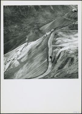
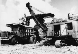
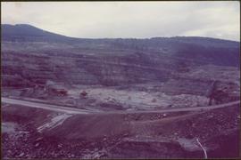
Photograph depicts cable-operated shovel loading two Kenworth haul trucks on road in mine area at high elevation. Three unidentified men are gathered around truck in foreground. Valley and mountain range in distance.
File includes six aggregations of photographs which have been assembled in this file in order to maintain the integrity of each group by keeping the photos arranged together, though each group features operations pertaining to multiple files in this subseries. Includes groups featuring photos from 1961, 1965 1971, a helicopter trip, a community album, and a workplace album. Photographs depict images pertaining to the following operations at Cassiar, B.C.: mining, milling, maintenance, labratory tests, and tramline and town operations. Images featuring operations of the company town include the grocery store, bank, churches, school, library, lounge, pool, theater, community center, outdoor recreation, hospital, dentist, cafeteria, bus route, residences, air strip, firehall, laundromat, park, police, and newspaper.
Photograph depicts buildings at various locations in mine: crushing plant (centre?) and what is believed to be the original tramline loading station on left. Mine road featured in center, blasthole drill visible near dump truck in midground. Mine valley in background. Photo believed to have been taken from mine's South Peak. Handwritten annotation on verso of photograph: "1961".
Photograph depicts an Atlas Copco Drillmaster (blasthole drill) near the mine road, mountainside in background. This is a precision hammer drill which had its own power source. It is believed that this photo was taken on the North ridge, near the cirque dump. Handwritten annotation on verso of photograph: "1961".
Photograph depicts a man wearing a hard hat preparing explosive material, mountains in background. Dog stands near edge in midground, large bags of Ammonium Nitrate in right foreground. Handwritten annotation on verso of photograph: "1961".
Photograph depicts explosion, part of the bench-mining process employed at Cassiar. Handwritten annotation on verso of photograph: "1961".
Photograph depicts crawler cable shovel, bucket over box of Kenworth truck in excavation area of mine. Handwritten annotation on verso of photograph: "1961".
Photograph depicts a large shelter over building believed to be power house. Electricity lines cross midground and run to power house. A man can be seen crossing the foreground by steel frame supplies, and a second building is partially visible on right. Mountains stand in background and a crane can be seen operating in front of power house. Handwritten annotation on verso of photograph: "1961".
Photograph depicts snowy mountaintop, wooden shelter and truck in foreground. Corresponding note on accompanying photo description page: "Pictures taken July 2nd, 1952. 1. Picture taken from campsite showing snow on talus."
Photograph depicts mountain side, semi-covered in snow. Snowbank in foreground. Corresponding note on accompanying photo description page: "8. Shows snow conditions in gully just north of talus deposit on south slope. Note considerable snow still above road. Estimated depth of snow here to be from 10 to 20 feet [see also item 2000.1.1.2.229]."
Photograph depicts man standing on dirt road. Snowbank to right of man is almost shoulder-height and disappears as road continues. Corresponding note on accompanying photo description page: "12. Indicates snow along the mountain road."
Handwritten annotation below photo on page taped to photograph: "PHOTO #3 Showing approx. area covered by Asbestos - serpentine float". The approximate area has been outlined in blue ink on verso of photograph. Photo taken from lower level in valley, trees in foreground, outcrop visible in distance.
Photographs depict construction of the new mill, each taken from approximately the same distance and featuring two different angles of the building. Construction work progresses from framework to sheeting and siding. Vehicles, piles of building supplies, and a construction trailer are often in foreground, mountains in background. It is believed that these photographs were taken during a labour dispute. Each photo has been annotated on recto with the date and time of day, and some document the number of workers on site. Annotations include: "2 days work", "work gets less & less", "not much for 4 men", "very little done - less than usual low performance", "0° - 20° weather must have thickened their blood".
Cassiar Asbestos Corporation Ltd opened a second mine in 1967 at what became the one-industry town of Clinton Creek, Y.T. File contains photographs depicting different areas of operations at Clinton Creek. Locations include the mine, plant, town, tailings pile, main office, the 40 Mile River, and surrounding area. Town photos depict the grocery store, cafeteria, medical clinic, school, auditorium residential area, Connell Street and power house. File also includes aerial photographs and images depicting forest fighting, photographers capturing the tailings pile, asbestos samples, mining machinery, staff offices, and operations in the mill, lab, and garage.
Additional photographs integrated into file depict Clinton Creek's surrounding area, and three slides of a tailing pile explosion believed to be Clinton Creek.
Photograph depicts wood houses behind stand of trees in Cassiar valley. Truck, power poles, and road in foreground, mountains in background. Typed caption below photo in original duotang album: "Two Bedroom Pan-Abode Houses - Cassiar Townsite". Handwritten annotation on verso: "Sept 1954".
The topographic map shows mine and campsite holdings within the proposed mine site. Asbestos deposits, the tramline and water bodies, such as Troutline Creek, are also included.
Annotations include certain lot titles being crossed out as well as as indication of missing survey information.
Item is a photograph of the diversion tunnel as engineers plan to blast the plug to allow the Peace River to be diverted for construction of the W.A.C. Bennett Dam.
Item is a photograph of the Bennett Dam.
Item is a photograph of the women and children on Rathrevor Beach.
Item is a photograph of a truck hauling logs from the shores of a lake.
Item is a photograph of the construction of the W.A.C. Bennett Dam
Item is a photograph of a house under construction. Unknown individual sits on ground in foreground.
Item is a photograph of people and boats on a river’s edge.
Item is a photograph of people and boats on the shore of a river.
Item is a photograph of Prince George taken from the air on August 2, 1965.
Item is a photograph of Prince George taken from the air, looking east with the Cameron Street Bridge in the foreground.
Photograph depicts Knox McCusker’s pack train traversing across an unidentified mountain ridge, ca. 1930. Caption on verso reads: “Knox McCusker’s pack train, ‘30’s”.
Twenty-three year old Violet stands wearing a polka dot dress in a group of unidentified men, women and children. Body of water and tree-covered hill on opposite shore in background. Handwritten caption below this photo reads: "Pr. Rupert, 1928 End of Road Construction".
Virginia and older brother Arthur (Art) hold hands in grassy field. Hills believed to be near Hazelton, B.C. are visible in background.
Hermina stands on shore close to water's edge at South Fort George. A power pole stands in water midground, in front of large white riverboat. Tree-covered hill on opposite shore in background. Handwritten annotation on verso of photograph: "Mother near the boats when the water was high."
Trees and riverbank cross midground. Single tree in foreground, mountain in background.
Handwritten annotation on verso of photograph: "G.T.P. 1st Passenger Train From Prince Rupert. Mile 45. June. 14th 1911. Copyright. F. Button. PHOTO. Pr. Rupert. No. 240." Photograph depicts three men (two sitting on chairs) on caboose of train. Power poles run parallel to tracks, which curve to the right of the image. Train tracks in foreground, forest and mountain in background.
Handwritten annotation on recto of photograph: "Front St. Hazelton in Winter. 12 J.W. [...]" Tree line, field, and hills in background. Handwritten annotation on verso of photograph: "Miss. Nellie [Nelville] G. Caranaugh".
Six men stand in small white boat on water close to shore. The four men on left are dressed in formal attire. H. G. T. Perry stands on far left next to Hugh Taylor. Small farm can be seen on shore in midground, treeline and distant hills in background.
Photograph depicts a log bridge interrupting a wide dirt road in forest. Distant hills in background. Image has been cropped to an oval shape. Handwritten annotation on verso of photograph: "Fort George - Hazleton Highway Near Burn's Lake".
Photograph depicts two miners standing on either side of wooden sluicing trough in rocky area. Man on left pans for gold. Hills in background. Handwritten annotations on verso of photograph: "PLACER MINERS AT WORK INGINECA RIVER BC", "PHOTO WWW".
Photograph depicts farmstead in cleared area of forest. Plowed and fenced area on left, buildings and firewood on right.
Photograph depicts four men wearing suits and ties, standing in front of mine adit in rocky area, bushes in background. Handwritten annotation on recto of photograph: "1939 H.F. (Bert) Glassey with black hit in middle" (information regarding Glassey believed to be incorrect).
Photograph depicts a man standing in a small canoe, facing a second man walking along the shore. Hills on opposite shore in background. Handwritten annotation on recto of photograph: "Finlay Rapids. Peace River."
Photograph depicts town site in foreground, lake and mountains in background. Handwritten annotation on recto of photograph: "Atlin: Atlin, Atlin Lk, & Atlin Mts. looking N.west from Glassey's (Govt. Agent) window."
Photograph depicts town in distance, believed to be Atlin, B.C. Lake in foreground, hills in background. See also items 2009.5.2.63 & 2009.5.2.64.
Photograph depicts river winding through range of hills, bridge visible in distance.
Photograph depicts a small building in low valley, tall hills in background, trees in foreground.
Photograph depicts wide body of still water, with rapids or small waterfall in bottom right corner. Shore in foreground, trees and hills on opposite shore in background.
Photograph depicts water with bog-like shore and ice floating in foreground. Buildings visible in distance, cliffs in background.
Photograph depicts railroad tracks along unidentified river or lake. Trees, grass, and fence in foreground, hills on opposite shore in background.
Photograph depicts pieces of ice floating on river, forest trees on either side.
Photograph depicts pieces of ice floating on river, forest trees on either side, hills in distance.
Photograph depicts a river or lake, and opposite shore in background. A garden can be seen behind fence in foreground.
Photograph depicts man reclining against one of three tents. Picnic table and trees in foreground, water in background.