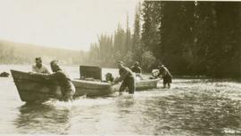
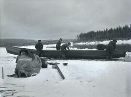
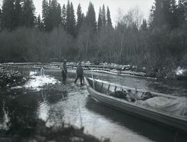
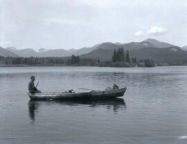
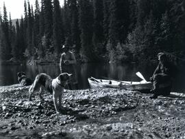
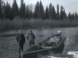
Photoraph depicts two men, Emil Bronlund and Clarence Waldof, standing beside a long motorboat at the edge of Crooked River in front of a forested landscape.
Photograph depicts two men, Clarence Waldof and Henry Waldof, posing for a photo while at work clearing dirt in front of a house in Prince George.
Photograph depicts two men (Emil Bronlund and Henry Waldo) in conversation while at work clearing dirt in front of a house in Prince George.
Photograph depicts two men, Emil Bronlund and Clarence Waldof, posing for a photograph at a farm in Prince George.
Fonds consists of textual material and photographs documenting the life and work of J.O. Skook Davidson including journal entries, expense listings, receipts, licenses, newspaper clippings, publications, correspondence, and photographs.
Subseries contains publications intended for employees and the general public, produced by Canadian National Railways, concerning labour unions, uniform code, operating rules, maintenance of way, general instructions, examination material, handling of hazardous material, operating guides, safety, and the Royal Tours of 1939 and 1959.
Photograph depicts a winter landscape with Mt. Park visible.
Postcard image of Ocean Falls with mountain in background
Street view photograph looking down Carson Avenue at the Front St. intersection in Quesnel, BC. Several identified businesses line the gravel avenue on the right; however Cowan's Hardware store is visible at the intersection on the left. Printed annotation on recto reads: "Carson Ave., Quesnel, B.C. 1930 Looking East."
Annotation on verso: "Log jam Ingenika"; annotation on recto: "Ingenika River 1930. Clearing boat passage...; Log jam Ingenika" Photo depicts two surveymen clearing a log jam in the river.
Annotation on recto: "Ingenika River 1930. Log jamb [sic] 3 miles below Perry Creek".
Annotation on recto: "Aero. Signal 1930". Photo depicts three men and three pack dogs seated at the top of a signal marker.
Annotation on recto: "Hudson Bay Post, Fort Graham, B.C." Photo depicts four men standing outside the Hudson Bay Post Office door"
Annotation on recto: "Ingenika River 1930"; annotation on verso: "Ingenika River 1930". Photo depicts five survey crewmen pullng a fully loaded boat and a dog along the Ingenika River.
Annotation on recto: "Breaking log jam, 1930; Log jamb [sic] Ingenika River 1930".
Overview of the Giscome sawmill behind road. Lumber yard is visible in foreground while mill stands in background.
Handwritten annotation in pencil on verso: "Giscome Mill / lumber yard in foreground".
Fully loaded logging truck driving along a wood plank logging road. Another road under construction is also visible through forest in background.
Handwritten annotation in pencil on verso reads: “Logging - Giscome B.C. Plank truck road - also road under construction showing sills & cribbing."
Item is a photocopied version of Percy Barr's "The Effect of Soil Moisture on the Establishment of Spruce Reproduction in British Columbia" from the Yale University School of Forestry Bulletin No. 26.
Fonds consists of 1 copy of an unpublished manuscript ("A Man's Country") written by Norah Banbery Doherty, and a photocopied article written by Doherty for the 11 April 1939 issue of the Express and Star
Bertha Collison stands on lawn in front of house (wife of Rev. W.E. Collison).
Handwritten annotation on verso reads: "Mother / Prince Rupert".
Collection consists of 11 digitized images of Prince George in the 1930s. Includes depictions of snow removal, flooding of the Fraser and Nechako Rivers, the CNR rail yard, and the railway bridge.
Photograph depicts (from left to right) Bill McPhee, an unidentified man, a dog, and Frank 'Shorty' Weber standing in tall meadow grass in front of a sparsely forested landscape in front of a mountain range. The location of the photograph is noted to be at Duck Creek below Copper Mountain; however, those names may no longer be in current use. Location is assumed to be approximately 55.979291, -125.208415 near what is currently named Wasi Peak.
Frank ‘Shorty’ Weber had a trapline on the upper Ingenika for over 30 years. and he was well-known in the Finlay River area.
Photograph depicts four men seated around a small camp in front of Copper Mountain. The location of the photograph is noted to be at Duck Creek at Copper Mountain; however, those names may no longer be in current use. Location is assumed to be approximately 55.979291, -125.208415 near what is currently named Wasi Peak.
Photograph depicts Copper Mountain with forested area at base and grassy area in the foreground.
Photograph depicts (from left to right) Bill McPhee, Frank 'Shorty' Weber, and another man resting along the rocky terrain on the west slope of Copper Mountain with a forested area at the base of the mountain. In the background of the image another mountain range is visible. The location of the photograph is noted to be at Copper Mountain; however, that name does not appear to be in current use. Location is assumed to be somewhere in the vicinity of 55.979291, -125.208415, near what is currently named Wasi Peak.
Frank ‘Shorty’ Weber had a trapline on the upper Ingenika for over 30 years. and he was well-known in the Finlay River area.
Photograph depicts two men (Bill McPhee and Shorty Weber) standing at the summit of Copper Mountain with a snowy mountain range visible in the background of the image.
Photograph depicts a frozen pond located in a snowy landscape on the east side of Copper Mountain.
Photograph depicts two men and a dog standing in a grassy field at Duck Creek in front of a forested landscape with a mountain range in the background.
Photograph depicts two men standing on a boat floating between ice chunks down Finlay River below Deserter Canyon.
Photograph depicts five men repairing a boat pulled up on a snow covered shoreline beside the river at Finlay Forks.
Photograph depicts a large build up of ice along Parsnip River. In the midground there is a boat stopped at the shore and the background depicts a forested area in front of a snow-capped mountain range.
Photograph depicts two men pulling a boat through a shallow section of Crooked River in front of a forested landscape.
Photograph depicts Clarence Waldof, Henry Waldof, Ethel Waldof, and another woman swimming in Summit Lake.
Item is a photograph of the Boy’s Parliament taken on the steps of the Legislature in Victoria. Mr. Williston is on the left in the second row from the front.
Photograph depicts 3 men atop a large stack of logs. The logs are on a cart being pulled by a team of 8 horses. Near Longworth BC
The images comprising the Photographs Series of the Alex Manson Mining Collection, document various mining related activities such as: road construction, mining sites, mining equipment, individuals involved in various aspects of the mining industry in Northern British Columbia, digging of ditchlines, bridge construction, surveying, extraction techniques, Germansen Placer pipelines, mining camps and the transportation of mining equipment by bulldozer and horse and wagon.
Handwritten annotation on recto: "Plane carrying HG Perry 1930, - , at Ft. St. John, Peace River"
Photographs within this file depict Knox McCusker on surveying treks and at his home. Photographs also document his headstone and the monument erected in his memory.
Photograph depicts a group of officers in military uniform posed for a formal photo in front of a tree. Stamped annotation on verso reads: "Cleary & Elliott Photographers, Kingston, Jamaica". Typed identification list of officers glued to verso states: "Front row (left to right) Major W.R. Louden, Capt. G.E. Ryan, Major C.D. Cannon, Capt. E.G. Roulstone, Lt.-Col. C.J. Strong, Major W.T. Brown, Major D.B. Pollock, Capt. H.S. Lamb, Lieut. F.E. Eaton. Second row (left to right): Lieut. A.G. Gregory, Lieut. G.H. Burke, Capt. F.F. Rush, Capt. F.D. Dorchester, Lieut. J.C. Dorchester, Lieut. H.T. Moran, Capt. J.F. Heard, Lieut. A.G. Gray. Third row (left to right) Lieut. G.A. Yates, Capt. F.T. Fairey, Capt. N.E. Odlum, Lieut. A.C. Mc Gougan, Lieut. G.F. Black, Lieut. L.J. Fournier, Lieut. L.C. Aggett, Capt. S.G. West, Lieut. E.G. Lee. Fourth row (left to right) Lieut. N.M. Fleishman. Lieut. R.J. Rigby-Jones, Capt. A. Herstein, Lieut. I.M. Sutherland. Lieut. R.G. Wilson, Lieut. R.P. ap Roberts, Lieut. R.W. Gardner."
Overview of Giscome, BC showing built and natural landscape.
Handwritten annotation in pencil on verso: "Bunkhouse & Dining Room / Giscome BC".
Handwritten annotation in pencil on verso: "Daily Capacity 100,000 f.b.m. sawmill in foreground planer mill and lumber yard in background.”
Group can be seen in distance by canoe close to trees and cliff on opposite shore. Rocky shore of river in foreground.
Handwritten annotation on verso reads: " 'The Place of Echoes' The Big Creek at Kincolith. Dad, Jack, Joyce & Bob Stewart". Believed to be present in image are the son, grandson, and granddaughter of Archdeacon W.H. Collison, respectively: Rev. W.E. Collison, John (Jack) Macdonald and Joyce Collison.
Photograph depicts a large totem pole next to groomed dirt paths. Power poles and river visible in background.
Handwritten annotation on verso reads: "Edenshaw pole in park at Prince Rupert."
Postcard depicts a CPR streamliner crossing the Canadian Rocky Mountains.
Postcard depicts 'The Spiral Tunnels."
Item is a photocopied 1930 pre-emptor's map of Fort George, published by the British Columbia Department of Lands.
Photograph depicts men fishing off a rocky point between the Omineca and Osilinka Rivers.
Photograph depicts Clarence Waldof sitting on the bow end of a wooden boat floating on End Lake off the Osilinka River with a forested landscape along the shoreline. A mountain range is visible in the background of the photo.
Photograph depicts two men and two dogs resting near a wooden rowboat stopped along the shoreline of upper Osilinka River near Swiggums mining claims.