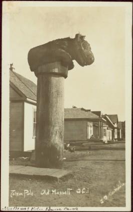
Affichage de 4377 résultats

Archival description
3218 résultats avec objets numériques Afficher les résultats avec des objets numériques
2009.7.1.080 · Pièce · October 1913
Fait partie de Archdeacon W. H. Collison fonds

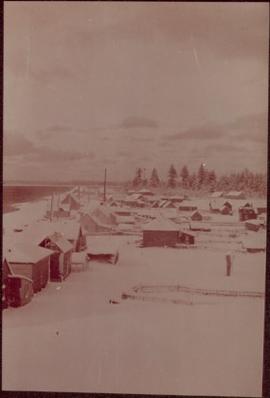
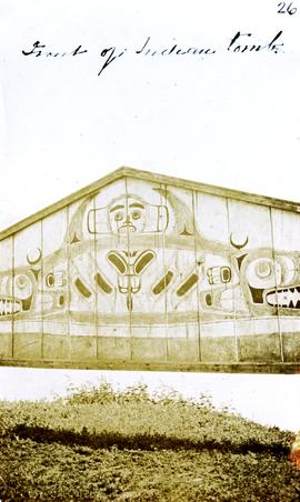
Large bear carving sits on top of wide pole, erected in memory of a chief of the Bear crest. Lines of houses stand in background.

Printed below image: "Totem Pole. Old Massett. Q.C.I / J.D. Allen photo Co."; handwritten below: "Mortuary Pole Bear [Crest?]"; on verso: "For Chapt. XIX. The old style and the new. Mortuary Pole & modern houses. No. 3. W.H.C. Oct. [6/ ?] 13".

2009.7.1.086 · Pièce · [1898?]
Fait partie de Archdeacon W. H. Collison fonds

Photograph depicts an unidentified individual leaning against a large overturned dugout canoe; barrel, bucket, and wood planks in foreground. Houses and other buildings can be seen on shore above beach, and two unidentified individuals stand in distance on far right.

Handwritten annotations on verso read: “Haida canoe on beach at Masset / ? 1898”; “No. 4 Page 5. Haida Canoe ready for steaming to [widen?] out and finish.”

An original negative of this photograph is held by the Canadian Museum of Civilization, no. 26664.

2009.7.1.109 · Pièce · [ca. 1900 - ca. 1930]
Fait partie de Archdeacon W. H. Collison fonds

Chief Allen sits in chair on raised wooden platform, with bear skin over his knee, and two more bear skins laid on wood blocks in front of him. House stands behind picket fence in background. Pot and pan sit to right of chair in foreground.

Handwritten annotation on verso reads: "Albert Allen Kincolith (Nisga Chief)".

Unidentified First Nations village
2009.7.1.163 · Pièce · [ca. 1910]
Fait partie de Archdeacon W. H. Collison fonds

Shoreline perspective of an unidentified coastal village situated on B.C.’s north coast. European style houses run parallel to a rocky shore. Seven men and one child stand within this frame and totem poles and a mortuary pole are also visible along the shoreline.

Children at play
2009.7.1.164 · Pièce · [ca. 1910]
Fait partie de Archdeacon W. H. Collison fonds

Seven young boys enjoying a game of tug-a-war alongside a wooden track. Track runs along a picket fence through a village. A small girl watches the fun from the sidelines and older woman carries a basket in the background. Handwritten annotation in pen on verso reads: “Native children at play”.

The Vancouver Supply Company building
2013.6.36.1.002.023 · Pièce · [May 1965]
Fait partie de David Davies Railway Collection

Photograph depicts the building for the Vancouver Supply Company located at 25 Alexander St. in Vancouver, B.C. It is at the center of the old downtown and may have been a former fire hall.

Former C.P.R. route in Vancouver, B.C.
2013.6.36.1.002.025 · Pièce · [May 1965]
Fait partie de David Davies Railway Collection

Photograph depicts the former C.P.R. route connecting existing False Creek rail yards and the Burrard shoreline main line. The view is looking southwest from the intersection of Powell St. (in foreground) and Columbia St. (not seen) in Vancouver.

Grand Central Hotel in south Vancouver
2013.6.36.1.002.043 · Pièce · [July 1965]
Fait partie de David Davies Railway Collection

Photograph depicts the Grand Central Hotel at the intersection of Marpole Ave and Hudson St. in south Vancouver. The hotel was built in 1912 by J.J. Graver and run from 1913-1915. It re-opened in 1920 as a home for incurables (veterans). In 1937 it became the provincial infirmary and closed in May 1965.

2013.6.36.1.002.054 · Pièce · Sept. 1965
Fait partie de David Davies Railway Collection

Photograph depicts the site of a former C.P.R. connection between the mainline into Vancouver and False Creek yards at West Pender St. In Vancouver. The rails are not used but still appear in the street and on the parking lot on the far side. Another parallel set of tracks 30 yards to the east are in daily use.

Barn at Darfield, B.C.
2013.6.36.1.002.066 · Pièce · Oct. 1965
Fait partie de David Davies Railway Collection

Photograph depicts a barn at Darfield, near Barriere, about 35 miles north of Kamloops. The English timbered cottage developed from this architectural form.

Disused schoolhouse in Delta, B.C.
2013.6.36.1.002.101 · Pièce · Apr. 1966
Fait partie de David Davies Railway Collection

Photograph depicts a disused schoolhouse with the dates "1925" and "1902" on it. It is on River Rd. on the south bank of the Fraser River in Delta, opposite the west end of Annacis Island.

2013.6.36.1.002.119 · Pièce · Apr. 1966
Fait partie de David Davies Railway Collection

Photograph depicts a painting on a fence outside a courthouse on Howe St. in Vancouver, B.C. The painting shows the natural grandeur of B.C. partially blocked out by a super motel with a bewildered moose forced to become an ornamental fountain. The whole forecourt is being bulldozed to make way for the Centennial fountain.

House fire
2013.6.36.1.003.025 · Pièce · [1964?]
Fait partie de David Davies Railway Collection

Photograph depicts a house fire possibly on 1000 Beach Block and Thurlow St. , caused by a wrecking gang.

Coal Harbour in Vancouver, B.C.
2013.6.36.1.003.062 · Pièce · [July 1965]
Fait partie de David Davies Railway Collection

Photograph depicts a general view of Coal Harbour in Vancouver, looking southeast and south with Marine Building (downtown) on extreme left and Stanley Park (unseen) at extreme right.

Downtown Vancouver, B.C.
2013.6.36.1.003.093 · Pièce · Mar. 1966
Fait partie de David Davies Railway Collection

Photograph depicts a view of downtown Vancouver taken from the east end of False Creek at the foot of Terminal Ave. The view is looking northwest. In the middle distance on the left is the pier of a railway bridge taking the Great Northern Railway line into the city. It was demolished in about 1915-1920 when a new Great Northern station was constructed.

Lund Harbour
2013.6.36.1.003.099 · Pièce · Apr. 1966
Fait partie de David Davies Railway Collection

Photograph depicts Lund Harbour, looking north, 12 miles north of Powell River. It is the most northerly point on the mainland accessible by car, on this part of the coast. Lund is 92 car miles north of the ferry terminal at Langdale.