887 resultados con objetos digitales
Muestra los resultados con objetos digitales
2009.6.13.49.1176
·
Item
·
[Feb. 1978?]
Parte de The Honourable Iona Campagnolo fonds
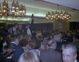
Photograph depicts a photographer and other men standing over a crowd at Northern BC Winter Games event in Prince George.
2009.6.13.49.1177
·
Item
·
[Feb. 1978?]
Parte de The Honourable Iona Campagnolo fonds
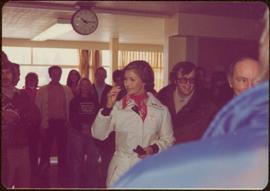
Photograph depicts Iona Campagnolo being directed to her seat by a man with a cigarette at a Northern BC Winter Games event in Prince George.

2012.13.1.3.046
·
Item
·
Jan. 1978
Parte de J. Kent Sedgwick fonds
Image depicts a view of Prince George from City Hall looking northeast along George Street. Map coordinates 53°54'46.3"N 122°44'41.9"W

2012.13.1.3.047
·
Item
·
Jan. 1978
Parte de J. Kent Sedgwick fonds
Image depicts a view of Prince George from City Hall looking north. Map coordinates 53°54'46.3"N 122°44'41.9"W

2012.13.1.3.049
·
Item
·
Apr. 1978
Parte de J. Kent Sedgwick fonds
Image depicts a view of Prince George from Cranbrook Hill looking southeast. Map coordinates 53°54'51.5"N 122°49'05.2"W

2012.13.1.3.050
·
Item
·
Apr. 1978
Parte de J. Kent Sedgwick fonds
Image depicts a view of Prince George from Cranbrook Hill looking east. Map coordinates 53°54'51.5"N 122°49'05.2"W

2012.13.1.3.051
·
Item
·
Apr. 1978
Parte de J. Kent Sedgwick fonds
Image depicts a view of Prince George from Cranbrook Hill looking southeast. Map coordinates 53°54'51.5"N 122°49'05.2"W

2012.13.1.3.053
·
Item
·
Apr. 1978
Parte de J. Kent Sedgwick fonds
Image depicts a view of Prince George from Cranbrook Hill looking east with pulpmill and downtown in background.

2012.13.1.3.048
·
Item
·
Apr. 1978
Parte de J. Kent Sedgwick fonds
Image depicts a view of Prince George from Cranbrook Hill looking east. Map coordinates 53°54'51.5"N 122°49'05.2"W
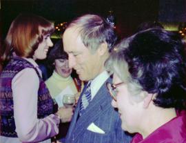
2009.6.1.344
·
Item
·
1978
Parte de The Honourable Iona Campagnolo fonds
Long building in background.
Handwritten annotation on verso reads: “with Pierre T + Rob B at P. George, winter 78”.
2009.6.1.346
·
Item
·
1978
Parte de The Honourable Iona Campagnolo fonds
Handwritten annotation on verso reads: “Northern BC Winter Games ’77 Prince George”.
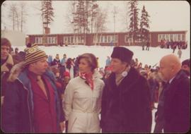
2009.6.13.49.0451
·
Item
·
February 1978
Parte de The Honourable Iona Campagnolo fonds
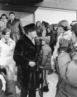
Photograph depicts Iona Campagnolo, Pierre Trudeau and Ron Basford talk with an unidentified crowd of children and adults at a children's speed skating event during the 1978 Northern BC Winter Games.
2009.6.13.49.1175
·
Item
·
[Feb. 1978?]
Parte de The Honourable Iona Campagnolo fonds
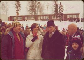
Photograph depicts Prime Minister Pierre Trudeau, Evelyn Basso, and a man standing in a crowd at a Northern BC Winter Games event in Prince George.

2012.13.1.3.052
·
Item
·
Apr. 1978
Parte de J. Kent Sedgwick fonds
Image depicts a view of Prince George from Cranbrook Hill looking east.
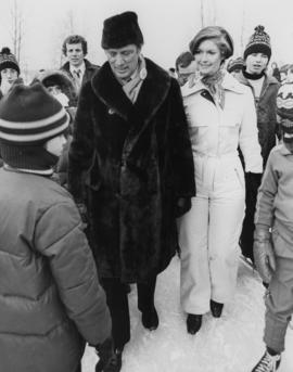
2009.6.13.49.0449
·
Item
·
February 1978
Parte de The Honourable Iona Campagnolo fonds
Photograph depicts Iona Campagnolo standing on ice with Pierre Trudeau at a children's speed skating event during the 1978 Northern BC winter games. Several unidentified children and adults surround them.
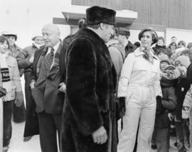
2009.6.13.49.0450
·
Item
·
February 1978
Parte de The Honourable Iona Campagnolo fonds
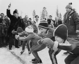
Photograph depicts Pierre Trudeau firing a starting pistol at a children's speed skating event during the 1978 Northern BC Winter Games. Iona Campagnolo, Ron Bassford and an unidentified crowd watch four children crouch at the starting line.
2009.6.13.49.0452
·
Item
·
February 1978
Parte de The Honourable Iona Campagnolo fonds
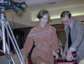
Photograph depicts Pierre Trudeau talking with a crowd of children and adults at a children's speed skating event during the 1978 Northern BC Winter Games. Iona Campagnolo stands behind Pierre Trudeau, looking downward. Two photographers are in the foreground.

2009.6.13.49.0453
·
Item
·
February 1978
Parte de The Honourable Iona Campagnolo fonds
Photograph depicts Pierre Trudeau talking with a four unidentified children at a children's speed skating event during the 1978 Northern BC Winter Games. Iona Campagnolo stands behind Pierre Trudeau. An unidentified man is in the foreground. Several unidentified adults are in the background.
2009.6.13.49.1174
·
Item
·
[Feb. 1978?]
Parte de The Honourable Iona Campagnolo fonds
Photograph depicts Prime Minister Pierre Trudeau and three women in a crowd at a Northern BC Winter Games event in Prince George.

2012.13.1.3.045
·
Item
·
Jan. 1978
Parte de J. Kent Sedgwick fonds
Image depicts a view of Prince George from City Hall looking northeast with the pulp mills in the background. Map coordinates 53°54'46.3"N 122°44'41.9"W

2012.13.1.3.054
·
Item
·
Apr. 1978
Parte de J. Kent Sedgwick fonds
Image depicts a view of Prince George from Cranbrook Hill looking southeast. Map coordinates 53°54'51.5"N 122°49'05.2"W

2012.13.1.129.18
·
Item
·
1979
Parte de J. Kent Sedgwick fonds
Image depicts a view of the landscape surrounding Tabor Mountain in Prince George, B.C.

2012.13.1.3.056
·
Item
·
Mar. 1979
Parte de J. Kent Sedgwick fonds
Image depicts Brunswick Street at 3rd Ave in -35 degree weather. Map coordinates 53°55'03.0"N 122°44'51.7"W

2012.13.1.3.057
·
Item
·
July 1979
Parte de J. Kent Sedgwick fonds
Image depicts the Central Business District of Prince George looking north from Connaught Hill. Map coordinates 53°54'41.4"N 122°44'58.5"W

2012.13.1.3.060
·
Item
·
Nov. 1979
Parte de J. Kent Sedgwick fonds
Image depicts a view of Prince George from Gunn Point in the L.C. Gunn Park looking north. Map coordinates 53°54'26.2"N 122°43'35.8"W.

2012.13.1.7.033
·
Item
·
Sep. 1979
Parte de J. Kent Sedgwick fonds
Image depicts the Columbus Hotel in Prince George, which was destroyed by a fire in 2008.

2012.13.1.7.034
·
Item
·
Sep. 1979
Parte de J. Kent Sedgwick fonds
Image depicts the Canadian Forces Recruiting Centre on the north side of 3rd Ave in Prince George, B.C.

2012.13.1.19.01
·
Item
·
1979
Parte de J. Kent Sedgwick fonds
Image depicts trains at the Grand Trunk Pacific railway roundhouse in Prince George, B.C.

2012.13.1.19.06
·
Item
·
1979
Parte de J. Kent Sedgwick fonds
Image depicts the Grand Trunk Pacific railway roundhouse in Prince George, B.C.

2012.13.1.19.10
·
Item
·
1979
Parte de J. Kent Sedgwick fonds
Image depicts the interior of the GTP roundhouse in Prince George, B.C.

2012.13.1.122.15
·
Item
·
[1979?]
Parte de J. Kent Sedgwick fonds
Image depicts logs being stripped of their bark at a saw mill in Prince George, B.C.

2012.13.1.3.061
·
Item
·
Nov. 1979
Parte de J. Kent Sedgwick fonds
Image depicts a view of Prince George from Gunn Point in the L.C. Gunn Park looking north. Map coordinates 53°54'26.2"N 122°43'35.8"W.

2012.13.1.7.030
·
Item
·
Sep. 1979
Parte de J. Kent Sedgwick fonds
Image depicts the south side of 3rd Ave in Prince George, B.C.

2012.13.1.7.031
·
Item
·
Sep. 1979
Parte de J. Kent Sedgwick fonds
Image depicts the Europe Hotel on the south side of 3rd Ave in Prince George, B.C.

2012.13.1.19.02
·
Item
·
1979
Parte de J. Kent Sedgwick fonds
Image depicts what is possibly a train fuelling station at the GTP Roundhouse in Prince George, B.C.

2012.13.1.19.03
·
Item
·
1979
Parte de J. Kent Sedgwick fonds
Image depicts what is possibly a train fuelling station at the GTP Roundhouse in Prince George, B.C.

2012.13.1.19.05
·
Item
·
1979
Parte de J. Kent Sedgwick fonds
Image depicts the Grand Trunk Pacific railway roundhouse in Prince George, B.C.

2012.13.1.19.12
·
Item
·
1979
Parte de J. Kent Sedgwick fonds
Image depicts machinery in the GTP roundhouse in Prince George, B.C.

2012.13.1.19.13
·
Item
·
1979
Parte de J. Kent Sedgwick fonds
Image depicts the GTP roundhouse in Prince George, B.C.

2012.13.1.19.14
·
Item
·
1979
Parte de J. Kent Sedgwick fonds
Image depicts the GTP roundhouse in Prince George, B.C.

2012.13.1.19.15
·
Item
·
1979
Parte de J. Kent Sedgwick fonds
Image depicts a train in the interior of the GTP roundhouse in Prince George, B.C.

2012.13.1.19.16
·
Item
·
1979
Parte de J. Kent Sedgwick fonds
Image depicts the interior of the GTP roundhouse in Prince George, B.C.

2012.13.1.40.07
·
Item
·
1979
Parte de J. Kent Sedgwick fonds
Image depicts an old, boarded up school, possibly the Central Fort George Traditional School in Prince George, B.C.
![Proposed Land Use 1978-2012, Official Community Plan, City of Prince George [1979 Amendment]](/uploads/r/northern-bc-archives-special-collections-1/c/e/d/ced2c18ae074ee79ace57d0454f038b5e09774ff682567e053093476af37c166/2023.5.1.14_-_1979_-_1978-2012_Official_Community_Plan_City_of_Prince_George_JPG85_tb_142.jpg)
2023.5.1.14
·
Item
·
12 Feb. 1979
Parte de UNBC School of Planning and Sustainability fonds
Item is a map depicting proposed land use between 1978 and 2012 in the City of Prince George. This map was drawn for the City of Prince George Community Plan; this particular version of the map was displayed in City of Prince George council chambers through 1979.

2012.13.1.3.055
·
Item
·
Mar. 1979
Parte de J. Kent Sedgwick fonds
Image depicts 3rd Ave at Brunswick Street in -35 degree weather. Map coordinates 53°55'03.0"N 122°44'51.7"W

2012.13.1.3.059
·
Item
·
Nov. 1979
Parte de J. Kent Sedgwick fonds
Image depicts a view of Prince George from Gunn Point in the L.C. Gunn Park looking north. Map coordinates 53°54'26.2"N 122°43'35.8"W.

2012.13.1.3.064
·
Item
·
Nov. 1979
Parte de J. Kent Sedgwick fonds
Image depicts a view of Prince George from Gunn Point in the L.C. Gunn Park looking north. Map coordinates 53°54'26.2"N 122°43'35.8"W.

2012.13.1.3.065
·
Item
·
Nov. 1979
Parte de J. Kent Sedgwick fonds
Image depicts a view of Prince George from Gunn Point in the L.C. Gunn Park looking north. Map coordinates 53°54'26.2"N 122°43'35.8"W.

2012.13.1.7.036
·
Item
·
Sep. 1979
Parte de J. Kent Sedgwick fonds
Image depicts the north side of 3rd Ave in Prince George, B.C.