File contains 3 strips of negatives depicting water control structures inluding pipes, culverts, and holding ponds. The strips were found in a photo lab pouch annotated "Sedimentation Pond Sept 1991" and addressed to "Cassiar Mining Corp. Attn; R. Tyne."
This file includes two major photographic collections concerning the construction and development of the underground mine at Cassiar, title the McDame Project.
The first collection includes fifteen monthly progress reports documenting the development from July 1988 to December 1989. The progress reports are authored by G. Verret, and were distributed to the executives of Cassiar Asbestos in Vancouver as well officials of the B.C. Government and other creditors of the Corporation. Most images are annotated and dated. Many of the loose photographs are accompanied by an inventory sheet.
Subjects depicted include: the staging area prior to mine development, the initial development of the “Vent Portal”, a jumbo drill working on the mine face, the working face marked for drilling and wired with fuses, a Caterpillar dozer clearing snow after an avalanche, scene of a fire in winter time, complete conveyor sump decline, mining vehicle parked on the “Lay-Down Area” presumably near the portal, the working face of the mine at various stages of development, 1563 portal being slashed, the removal of the overburden for the tramline loading station site, the construction of the transfer tower(s), construction of the stockpile area, the construction of a sedimentation pond, a presumed cave in, construction of footings for the conveyor, construction of the tramline loading terminal station, construction of the crusher building, a slash titled “Breakthrough in Access Ramp”, storage of powder and fuses, a washout in conveyor decline, fog at the portal in -30 degrees Celsius, the 1290 junction flooded, a slab of shotcrete which fell on and injured a miner while shotcreting, shotcrete blasted off walls for repairs, images of the “Hilti-test”, shots showing grade of drift, and structural failures in the 1350 adit.
Locations and structure within the underground mine depicted include: yellow ventilation ducting, ground support including steel screen and shotcrete, steel cables bolted unto ground support, puddles in the adits, the access road to the lay-down area, the exhaust drift, “Fans and Heaters in the 1415 adit”, the 1350 sump, the access ramp to the 1320, the exhaust ramp safety bay, the conveyor decline, the ventilation adit, the 1563 portal, the temporary repair shop at the 1415 portal, junctions of various drifts, the ”Fresh Water Pump & Pumphouse on lower Creek”, the “Ventilation Raise/1563 Platform”, a “Diamond Drill Station” at 6066 North in the underground mine, the “Bridge to the Gravel Pit”, the “Crushing and Screening Plant” in the gravel pit, the ventilation bulkhead in the conveyor decline, and the “Powder Magazine”.
People depicted include Rose Gay and R. Tyne on a tour of the underground mine, a geologist with a rockhammer, a miner identified as A. Jacobs working, contract miners Bruno and Marbel from Canadian Mine Development, and unidentified miners rockbolting, shotcreting, and drilling using jackleg drills.
Vehicle and mining equipment depicted include jeeps, pickup trucks, a front end loader, an unidentified a small unmanned tracked machine with a long arm, scoop trams, a land cruiser, an ore truck with a flat tire, the cone crusher, a “scissor lift”, a mobile shotcrete machine, a new grout pump, a new Boart Jumbo Drill, and a detached bucket half of a 413 ore truck.
The second collection depicts the McDame Project construction in 1986 and 1987.
Content of these photographs includes: various machinery used for excavating and drilling, underground progress of tunneling, supports, wire meshing, rock formations in mine, and exposed asbestos. There are no annotations regarding this photographs.
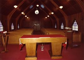
Photograph depicts interior of church believed to be the All Saints Anglican Community Church at Cassiar, B.C. Table and pulpit in foreground, pews and door in background. Stained glass windows line both sides of the building.
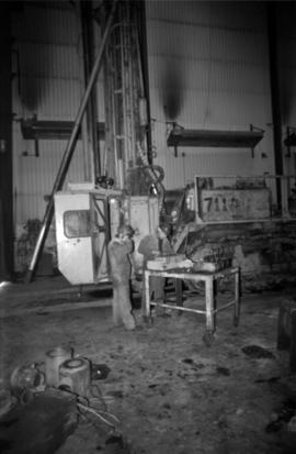
Photograph depicts two unidentified men in coveralls and hard hats, working in garage. Blasthole drill stands behind them in midground, walls in background.
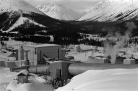
Mill building in left midground. Conveyor believed to be leading to tailings pile can be seen in foreground. Valley and mountains in background.
- File contains photographs done to item level description, depicting miscellaneous people and locations at or around Cassiar, B.C. This includes a photograph of renowned prospector William (“Bill”) Storie, Bill Pratt with a fox, a community gathering in a someone's home, and a hockey game.
- Also included but not to item level is a photo of "David Madore" as part of his application to Cassiar, photo of "William Field" a local hire maintenance mechanic, and photos of a RNWMP Post sign (Royal North West Mounted Police) that depicts annotations "Indian grave" , "Miners Cabin" , "Road House" , "Customs House" , "St. James Church" , "Swansons Store" etc., and 15 negatives of various individuals at what appears to be someone's home.
- Also included is cabin at Boya Lake, which used to be named Chain lake, located off the Stewart-Cassiar highway. This land of this cabin may have been involved legal issues , which was related to people at Cassiar.
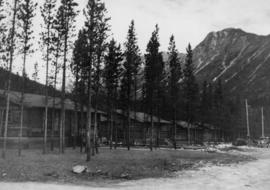
Photograph depicts wood houses behind stand of trees in Cassiar valley. Truck, power poles, and road in foreground, mountains in background. Typed caption below photo in original duotang album: "Two Bedroom Pan-Abode Houses - Cassiar Townsite". Handwritten annotation on verso: "Sept 1954".
Photograph depicts a log cabin in the woods with a small porch and moose antlers hanging from the roof.
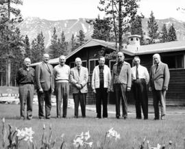
Photograph depicts group of eight men standing on lawn in front of building known as "House 130" or "Director's Lodge" (see item 2000.1.1.3.19.88). Left to right: Nick Gritzuk, Charles Rainforth Elliot, Jack Christian, W. Harold Connell, Plato Malezemoff (from Newmont Mining), Tam Zimmermann, Ken A. Creery, Fred Martin Connell. Daffodils and tulips planted in foreground, trees and mountains in background. Most men featured in photo are believed to be members of Cassiar's Board of Directors.
Photograph depicts group of eight men standing on lawn in front of building known as "House 130" or "Director's Lodge". Left to right: Nick Gritzuk, Charles Rainforth Elliot, W. Harold Connell, Jack Christian, Fred Martin Connell, Ken A. Creery, Plato Malezemoff (from Newmont Mining), Tam Zimmermann. Trees and mountains in background. Most men featured in photo are believed to be members of Cassiar's Board of Directors.
Blueprint of the Cassiar Recreational Centre depicting various details regarding aspects of the building. Perspectives included within the blueprint are top-down as well as cross-sections. There are notes by the architect towards how certain building aspects and details are to be found and built throughout the blueprint.
This blueprint depicts a cross-section layout of the recreational centre which includes a 1/4 scale drawing of a wall unit.
This blueprint depicts the general layout of the recreational centre. Top-down, side and front perspectives are used. The ground floor, second floor, outside walls and stage layouts are shown. Annotations in gold pen and pencil regarding clarification and changes to certain details are included. Numerical annotation at the bottom right hand of plan imposed new numbering system (3002/09/06).
This blueprint depicts the outside layout of the recreation centre and includes its north, south, east and west elevations. Details are included regarding the materials to be used for construction. Annotations in gold pen and pencil regarding clarification and changes to certain details are included. Numerical annotation at the bottom right hand of plan imposed new numbering system (3002/09/07).
This blueprint depicts a cross-section layout of the recreational centre which includes a 1/4 scale drawing of a wall unit. Annotations in gold pen and pencil regarding clarification and changes to certain details are included. Numerical annotation at the bottom right hand of plan imposed new numbering system (3002/09/09).
This blueprint depicts the overall framing structure of the recreational centre. Details include a cross section layout of the recreational centre with relevant framing dimensions, the locations and instructions for assembly as well as types of framing materials to be used. Annotations in gold pen and pencil regarding clarification and changes to certain details are included. Numerical annotation at the bottom right hand of plan imposed new numbering system (3002/09/10).
This blueprint depicts the gymnasium lighting layout. Also show is an isometric view of the air supply unit piping as well as a ventilating unit automatic control diagram. Included are detailed notes regarding system desriptions, its plan and layout as well as directions for the automatic control of the ventilation unit and heating systems. Annotations in gold pen and pencil regarding clarification and changes to certain details are included. Numerical annotation at the bottom right hand of plan imposed new numbering system (3002/09/12).
This blueprint shows the side profile of the proposed tramway to be built in Cassiar. It includes scale drawings of the crusher building, power house and support structures. The degree of tilt of the support structures are marked down where applicable. The side profile is divided into five sections due to the scaled height in elevation and the lack of drawing space. Annotation written along the leading edge of the blueprint reads "Proposed Tramway Riblet".
This blueprint shows the front and side profiles of the proposed jig back bucket for use in the tramway. Relevant measurements and dimensions are included as well as location placements for the track stand and traction rope.
This blueprint shows the top-down (showing the plan view) and the side view (showing elevation) of the transfer station layout. The process and operation of the jig back discharge and monocable loading are also included. Relevant measurements and dimensions are included as well as locations of the loading chute, the loading area, monocable as well as empty and loaded rope lines.
