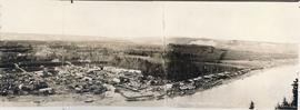
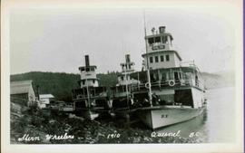
Showing 4134 results

Archival description
3619 results with digital objects Show results with digital objects
2002.17.6 · Item · 3 July 1912
Part of Henderson-Roe collection

Map is entitled "Latest Map of Fort George District" and published 1912. Includes Peace River Recording Land District, Fort George Land Recording District, and Cariboo Land Recording District. Several sections are marked with red pencil.

Album No. 1
2009.10.1 · File · 1926-1933
Part of Fred Jeffery Photograph Collection

Images within this album consist primarily of the fishing industry, river & landscapes, salmon cannery images (housing, people, workers, boats) on the Nass River and North Pacific Coast, ca.1926-1933. Images also feature indigenous First Nations peoples, totem poles, the parliament buildings in Victoria, B.C., and the C.P.R. Pier in Vancouver, B.C. Each photograph is accompanied by a handwritten description glued below or beside the image.

Album No. 2
2009.10.2 · File · 1921-1926
Part of Fred Jeffery Photograph Collection

This bound photo album comprises 122 photographic images featuring the fishing industry, river & landscapes, salmon cannery images (housing, people, workers, boats, machinery) and First Nations Peoples on the Nass & Skeena Rivers and North Pacific Coast. Images also include warships, freighters, automobiles, railway stations and trains, and some photographs of Yokohama, Japan and California ca.1924-25. Includes photographs of the 1924 Special Service Squadron World Cruise in Vancouver. Each photograph is accompanied by a handwritten description glued below or beside the image and each image is glued to the album page at its corners. The verso of front cover has a handwritten name plate:

Album No. 3
2009.10.3 · File · [between 1923 and 1926]
Part of Fred Jeffery Photograph Collection

Images within album consist primarily of fishery industry, river & landscapes, salmon cannery images (housing, people, workers, boats) on the Nass River and North Pacific Coast, ca.1924-1926. Each photograph is accompanied by a handwritten description glued below or beside the image.

2009.10 · Collection · 1921-1933

The Fred Jeffery Collection consists of three photograph albums comprising a total of 303 b&w photographs all dating from ca.1924-1933. The subject matter of these images consist primarily of the fishing industry, river & landscapes, salmon cannery images (housing, people, workers, machinery, boats) on the Nass River and North Pacific Coast. Notable are the photographs depicting indigenous (Nisga'a) people and places and Chinese and Japanese cannery workers. Identified canneries featured in these photographs include: Mill Bay Cannery, Namu Cannery, Klemtu Cannery, Shushartie Bay Cannery, Balmoral Cannery, North Pacific Cannery, Nass Harbour Cannery, Port Essington Cannery, Kitwanga Cannery, Port Nelson Cannery, Alert Bay Cannery, Dominion Cannery and ABC Co. Cannery. Photographs also include images of the Canadian Pacific Railway in both Vancouver and Sicamous, BC., as well as, images of the Legislative Assembly buildings in Victoria, the 1924 Special Service Squadron ships in Vancouver, early construction of the University of British Columbia in Vancouver, and town overviews of Yokohama, Japan (pre WWII).

Jeffery, Fred
2009.7.1.019 · Item · [ca. 1930]
Part of Archdeacon W. H. Collison fonds

Group can be seen in distance by canoe close to trees and cliff on opposite shore. Rocky shore of river in foreground.

Handwritten annotation on verso reads: " 'The Place of Echoes' The Big Creek at Kincolith. Dad, Jack, Joyce & Bob Stewart". Believed to be present in image are the son, grandson, and granddaughter of Archdeacon W.H. Collison, respectively: Rev. W.E. Collison, John (Jack) Macdonald and Joyce Collison.

2009.7.1.101 · Item · [ca. 1878 - ca. 1915]
Part of Archdeacon W. H. Collison fonds

Photograph depicts totem poles (crest poles?) in front of lodge buildings on river shore. Canoes can be seen floating in foreground, hills in background.

Handwritten annotation on verso reads: "Chapter XII. Number 1. Section of Indian Village on Nass River showing lodges and totems".

2009.7.1.150 · Item · [ca. 1878 - ca. 1915]
Part of Archdeacon W. H. Collison fonds

Photograph features a steep cliff across water, rocky shore in foreground.

Handwritten annotation on verso reads: "Up the 'Big Creek' at Kincolith B.C. Rock face called 'the place of echoes' by the Indian people."

2008.3.4.4.3 · Item · 1946
Part of Bridget Moran fonds

Photograph depicts three women sitting on beach in their Women's Royal Canadian Naval Service uniform. Purses and shoes lay beside them, large rock stands in background. Handwritten annotation on recto of photograph: "The California 'Beauties' 1946." Left to right: Betty Pincombe (aka 'Chick'), Bridget Moran, and Grace Boice (aka Tommy).

2008.3.1.83.2 · Item · [after 1981]
Part of Bridget Moran fonds

Photograph depicts lake in surrounding field. Grave marker on rock in right foreground. Handwritten annotation on recto of photograph: "This is a picture of the lake (part of it) the rock is in the bottom right corner on a knoll. You can see the plaque on it. But it isn't very clear."

Central British Columbia
2008.2.1.21 · Item · 1 May 1940
Part of Northern BC Cartographic Collection

Topographic map depicts communities, bodies of water, transport routes, parks, game reserves, posts, ports, radio stations, power sites (figures in horse power), steamship routes (distance in nautical miles), and precipitation. Mineral resources summarized locally in red ink.

2008.2.1.15 · Item · 1929
Part of Northern BC Cartographic Collection

Colour-coded map depicting surveyed lands respectively open and closed to preemption. Depicts land recording divisions, land district boundaries, government reserves, communities, bodies of water, and transport routes. Includes topographical inset.

2008.2.1.10 · Item · 1924
Part of Northern BC Cartographic Collection

Colour-coded map depicting lands surveyed as alienated, reserved, and having a timber license, lease, or sale. Depicts land recording divisions, land district boundaries, communities, bodies of water, and transport routes. Includes insets of Stephens Island and Egeria Reach.

Northern British Columbia
2008.2.1.18 · Item · 1 May 1933
Part of Northern BC Cartographic Collection

Regional map depicting communities, parks, customs posts, airports, radio stations, hatcheries, bodies of water, transport routes, communication lines, elevation points, and lines of batholith contacts. Includes an inset of St. Elias Mountains. Includes “Special Note on the Mineralization of this Map Area” from Bureau of Mines, Victoria, B.C.

2008.2.1.09 · Item · 1 December 1923
Part of Northern BC Cartographic Collection

Colour-coded topographic map depicting lands surveyed as alienated, reserved, or statutory timber land. Depicts land district boundaries, land recording divisions, HBC posts, triangulation stations, telephone lines, communities, bodies of water, and transport routes. Defines resource type areas (“Land Form,” “Soil,” “Forest Cover,” “Grazing,” “Geological & Mineralogical,” “Fur-Bearing Animals & Game”). Includes explanatory “Natural Resources Reference.”

Bulkley Sheet
2008.2.1.20 · Item · 1937
Part of Northern BC Cartographic Collection

Colour-coded map depicts lands surveyed as alienated, available for purchase or lease under Taxation Act, or reserved. Depicts land district boundaries, land recording divisions, triangulation stations, telegraph/telephone lines, communities, bodies of water, and transport routes.

Fort George
2008.2.1.27 · Item · 1 May 1949
Part of Northern BC Cartographic Collection

Colour-coded map depicts surveyed lands alienated, available for purchase or lease under Land Act, or available for pre-emption. Depicts land districts, land recording districts, provincial forests, parks, game reserves, communities, bodies of water, transport routes, communication lines, triangulation stations, and government reserves.

2008.2.1.13 · Item · 1926
Part of Northern BC Cartographic Collection

Colour-coded map depicting surveyed lands alienated, reserved, in B.C. Land Settlement Board Area, or open for preemption. Depicts land districts, land recording divisions, communities, bodies of water, transport routes, and communication lines.

Fort George
2008.2.1.24 · Item · 3 January 1944
Part of Northern BC Cartographic Collection

Colour-coded map depicting surveyed lands alienated, available for purchase or lease under Land Act, and available for pre-emption. Depicts land districts, land recording districts, provincial forests, parks, game reserves, communities, bodies of water, transport routes, communication lines, and triangulation stations.

Stuart Lake Sheet
2008.2.1.22 · Item · 1 August 1940
Part of Northern BC Cartographic Collection

Colour-coded topographic map depicting lands surveyed as alienated, available for purchase or lease under Land Act, or reserved. Depicts land district boundaries, land recording divisions, provincial forest boundaries, HBC posts, triangulation stations, telephone lines, communities, bodies of water, and transport routes.

2008.2.1.08 · Item · 15 February 1923
Part of Northern BC Cartographic Collection

Colour-coded map depicting lands surveyed as alienated, reserved, Statutory Timber Lands, B.C. Land Settlement Board Area, or open for pre-emption. Depicts land districts, land recording divisions, communities, game reserves, bodies of water, transport routes, and communication lines.

Nechako Sheet
2008.2.1.23 · Item · 1 December 1942
Part of Northern BC Cartographic Collection

Colour-coded topographic map depicts surveyed lands alienated, available for purchase or lease under Land Act, and available for pre-emption. Depicts land districts, land recording districts, provincial forests, parks, triangulation stations, communities, bodies of water, transport routes, and communication lines.

Peace River
2008.2.1.25 · Item · 2 January 1945
Part of Northern BC Cartographic Collection

Colour-coded topographic map depicting surveyed lands alienated, available for purchase or lease, or available for pre-emption. Depicts land districts, land recording districts, parks, communities, bodies of water, transport routes, communication lines, and triangulation stations.