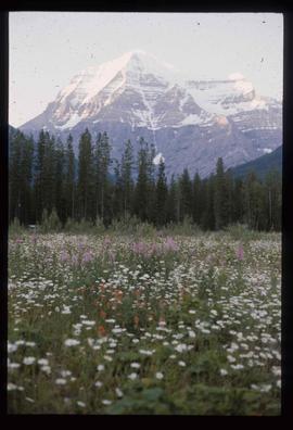
Image depicts a view of Valemount with numerous mountains in the background.
Image depicts Mt. Robson.
Image depicts a view of an area somewhere near McBride in the Rocky Mountain Trench.
Image depicts the CN Station in McBride, B.C.
Image depicts the rear-end of the CN Station in McBride, B.C.
Image depicts an old house somewhere in McBride, B.C.
Image depicts a machine shop somewhere in McBride, B.C. The sign above the door reads "McBride Air Cooled Engine Services Ltd."
Image depicts the Elks Hall in McBride, B.C.
Image depicts a heavily forested area located in the Rocky Mountain Trench, possibly near Dome Creek or Lamming Mills, B.C.
Image depicts a Yellowhead Realty sign in Lamming Mills, B.C. It reads: "For Sale, entire community, 50 buildings, 60 acres."
Image depicts a beehive burner in the community of Crescent Spur, B.C.
Image depicts several old houses and an old, yellow pick-up in Lamming Mills, B.C.
Image depicts what appears to be the old, abandoned mill in Lamming Mills, B.C.
Image depicts the CN Railway and Station at Goat River, B.C.
Image depicts an old building that used to be a store and post office in Dome Creek, B.C.
Image depicts a house somewhere in Dome Creek, B.C.
Image depicts a cookhouse at Sinclair Mills, B.C.
Image depicts a snow-covered road with vehicle tracks, and several houses. The location is uncertain.
Image depicts a dilapidated house in Sinclair Mills, B.C.
Image depicts a small house with brightly coloured door and window frames in Penny, B.C.
Image depicts mountains in the background and two unidentified individuals standing on a dirt road in the bottom left corner. The location is uncertain, likely Longworth, B.C.
Image depicts a house surrounded by trees and a mountain in the background; it is most likely located somewhere in or near Longworth, B.C.
Image depicts a riverboat on the Fraser River, possibly in Longworth, B.C.
Image depicts what appears to be a teepee at an uncertain location.
Image depicts a road covered in snow running through the woods at an uncertain location.
Image depicts a dirt road and a possibly abandoned building at an uncertain location.
Image depicts an older building with numerous vehicles parked out front in Upper Fraser, B.C. Map coordinates 54°07'03.5"N 121°56'34.4"W
Image depicts a row of houses in Upper Fraser, B.C. Map coordinates 54°06'51.6"N 121°56'26.3"W
Image depicts a field in Giscome, B.C. On the right side of the image, in the background, is a grey strip that appears to be a mine, possibly the quarry at Eaglet Lake in Giscome, B.C. Map coordinates 54°03'52.9"N 122°22'10.0"W
Image depicts the Giscome B.C. townsite from across the railroad tracks looking southeast. Map coordinates 54°04'19.7"N 122°22'04.7"W
Image decpicts the old road to the townsite in Giscome, B.C. Map coordinates 54°04'19.7"N 122°22'04.7"W
Image depicts a house with the main floor and entrance high off the ground. The location is uncertain, likely Giscome, B.C.
Image depicts a large, old and collapsing barn, as well as a nearby house of the dairy farm in Giscome, B.C. Map coordinates 54°03'53.3"N 122°21'22.6"W
Image depicts the former location of employee houses on mill site in Giscome, B.C. Map coordinates 54°04'23.4"N 122°22'16.9"W
Image depicts the old CN station in Giscome, B.C. Map coordinates 54°04'20.7"N 122°22'01.1"W
Image depicts the Giscome mill foreman's house on the hill, with Eaglet Lake in the background and numerous piles of logs in the foreground. Map coordinates 54°04'28.0"N 122°22'05.8"W
Image depicts several old buildings in a field, one of which has a caved-in roof, in Newlands, B.C. Map coordinates 54°06'28.2"N 122°12'01.0"W
Image depicts three people standing at the front door of a house at an uncertain location.
Image depicts several boats on what appears to be a river, and an old beehive burner in Penny, B.C.
Image depicts a grave-marker with several names, it reads: "In Memory of Edith Golder, Winnifred Golder, Baby Pelton, Mrs. Nazarek, Baby Nazarek, Baby Wazylyk 1915 - 1929." It is located in the Willow River Cemetery.
Image depicts numerous tree logs floating on a body of water. The location is uncertain, but is likely Eaglet Lake.
Image depicts the mill site at Giscome, B.C. Map coordinates 54°04'19.7"N 122°22'04.7"W
Image depicts the mill site at Giscome, B.C. A sign in the foreground reads "Maynard's Industrial Auctioneers." Map coordinates 54°04'19.7"N 122°22'04.7"W
Image depicts a food stand at the mill site at Giscome, B.C. Map coordinates 54°04'19.7"N 122°22'04.7"W
Image depicts a street in Giscome B.C. The Giscome Store is located on the left side of the image with the church in the background. Map coordinates 54°04'18.5"N 122°21'57.7"W
Image depicts the Giscome, B.C. town site with the Giscome railway station and the Giscome store in the center surrounded by vehicles. Map coordinates 54°04'18.5"N 122°21'57.7"W
File contains slides depicting places along the east line of the BC Railway.
Image depicts a red boat on a river, possibly the Fraser, near Penny, B.C.
Image depicts an old, abandoned cabin with ivy growing up the side. The location is uncertain.