Print preview Close
Showing 4134 results
Archival description
The Duke of Connaught
The Duke of Connaught
Canadian urban planning secondary sources
Canadian urban planning secondary sources
City Beautiful movement
City Beautiful movement
Survey of Prince George
Survey of Prince George
Central BC resource surveys
Central BC resource surveys
Dominion Land Survey system
Dominion Land Survey system
Land survey information
Land survey information
Pre-emption crown land grants
Pre-emption crown land grants
Prince George street names
Prince George street names
Census areas
Census areas
City of Prince George boundary expansion
City of Prince George boundary expansion

"British Columbia's Skeena Salmon"

Poling a canoe
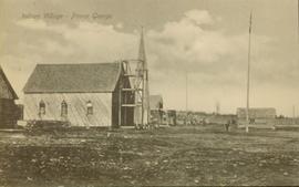
Wooden church at Lheidli T'enneh village site
First Nations Village at Fraser Lake
Arthur Holland Album
Arthur Holland Album

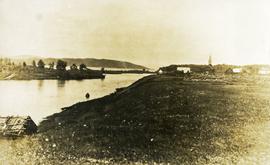
View of Hudson Bay Company buildings from the burial grounds of the Lheidli T'enneh Nation at Fort George

Lheidli T'enneh Village
Maps & Oversize
Maps & Oversize
"Bella Coola area Invasive Plants Distribution as per IAPP data - Feb. 19"
"Bella Coola area Invasive Plants Distribution as per IAPP data - Feb. 19"
"Central Coast Regional District (CCRD) - Scentless Chamomile, Sheep Sorrel, Spotted Knapweed, St Johns Wort, Thistle spp, Water Hemlock, Western Goats beard, Wildlife Mustard, Yellow Toadflax"
"Central Coast Regional District (CCRD) - Scentless Chamomile, Sheep Sorrel, Spotted Knapweed, St Johns Wort, Thistle spp, Water Hemlock, Western Goats beard, Wildlife Mustard, Yellow Toadflax"
"Central Coast Regional District (CCRD) - Blueweed, Broadleaf Plantain, Bull Thistle and Burdock"
"Central Coast Regional District (CCRD) - Blueweed, Broadleaf Plantain, Bull Thistle and Burdock"
"Central Coast Regional District (CCRD) - Canada Thistle, Common Tansy, Diffuse Knapweed, Hawkweed spp, Curled Dock, English Ivy, Knotweeds"
"Central Coast Regional District (CCRD) - Canada Thistle, Common Tansy, Diffuse Knapweed, Hawkweed spp, Curled Dock, English Ivy, Knotweeds"
"Habitat Types and Terrain Assessment of the Columbia River Marshes"
"Habitat Types and Terrain Assessment of the Columbia River Marshes"
"North Coast LRMP G2G Outcomes - Proposed Final Zoning - December 2005"
"North Coast LRMP G2G Outcomes - Proposed Final Zoning - December 2005"
"B.C.'s Endangered Wilderness: A Comprehensive Proposal for Protection"
"B.C.'s Endangered Wilderness: A Comprehensive Proposal for Protection"
"Super Crop Forage Seeds for B.C."
"Super Crop Forage Seeds for B.C."
"Producing Mines and Significant Mineral and Coal Deposits of British Columbia"
"Producing Mines and Significant Mineral and Coal Deposits of British Columbia"
"Mineral and Coal Strategic Economic Development Plan North West British Columbia"
"Mineral and Coal Strategic Economic Development Plan North West British Columbia"
"Groundhog Coalfield Properties and Geology"
"Groundhog Coalfield Properties and Geology"
"Comox & Nanaimo Coalfields Properties and Geology"
"Comox & Nanaimo Coalfields Properties and Geology"
"Southeastern British Columbia Coal Properties and Geology"
"Southeastern British Columbia Coal Properties and Geology"
"Areas Alienated or Restricted from Mining in British Columbia 1983"
"Areas Alienated or Restricted from Mining in British Columbia 1983"
"Energy Resources of British Columbia"
"Energy Resources of British Columbia"
"Vancouver Island's Forests"
"Vancouver Island's Forests"
"Agriculture, Fish & Food in B.C."
"Agriculture, Fish & Food in B.C."
"Cariboo-Chilcotin Existing Tourism Use"
"Cariboo-Chilcotin Existing Tourism Use"
"Okanagan Connector"
"Okanagan Connector"

Aerial photograph of West Coast Trail at Nitinat Narrows

Aerial photograph of West Coast Trail at Carmanah Lighthouse

Aerial photograph of West Coast Trail at Tsusiat Falls

Aerial photograph of West Coast Trail at Tsusiat Point Hole in the Wall

Aerial photograph of West Coast Trail at Tsusiat Falls
Print Photographs
Print Photographs

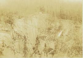
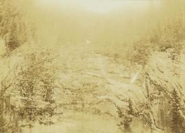
Peace River Canyon

Main Street of Rolla
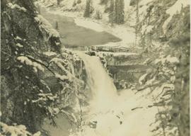
Snake Indian Falls

Craggy mountain peak covered with coniferous trees and snow
Mountain goat walks along a steep precipice
Mountain goat along the edge of the deeply cut banks of an unseen river